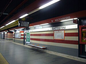
Battistini (Rome Metro)
This article needs additional citations for verification. (February 2023) |
 | |||||||||||
| General information | |||||||||||
| Coordinates | 41°54′23″N 12°24′53″E / 41.906461°N 12.414722°E | ||||||||||
| Owned by | ATAC | ||||||||||
| Tracks | 2 | ||||||||||
| Construction | |||||||||||
| Structure type | Underground | ||||||||||
| History | |||||||||||
| Opened | 1 January 2000 | ||||||||||
| Services | |||||||||||
| |||||||||||
| Location | |||||||||||
 | |||||||||||
| Click on the map to see marker | |||||||||||
Battistini is an underground station on Line A of the Rome Metro, situated at the junction of Via Mattia Battistini and Via Ennio Bonifazi, in the 14th district. The station was inaugurated, together with the others from Valle Aurelia - Battistini on 1 January 2000 since when it has been the northernmost station on Line A.[1]
Services[edit]
This station has:
 Access for the disabled
 177 Park and Ride spaces
 Ticket office
 Escalators
Located nearby[edit]
- Via Boccea
- Forte Boccea
- Santa Sofia a Via Boccea
References[edit]
External links[edit]
![]() Media related to Metropolitana di Roma linea A - Battistini at Wikimedia Commons
Media related to Metropolitana di Roma linea A - Battistini at Wikimedia Commons

