
Basilica San Paolo (Rome Metro)
 | |||||||||||
| General information | |||||||||||
| Coordinates | 41°51′22″N 12°28′41.5″E / 41.85611°N 12.478194°E | ||||||||||
| Owned by | ATAC | ||||||||||
| Line(s) | |||||||||||
| Construction | |||||||||||
| Structure type | Aboveground | ||||||||||
| History | |||||||||||
| Opened | 1955 | ||||||||||
| Services | |||||||||||
| |||||||||||
| Location | |||||||||||
 | |||||||||||
| Click on the map to see marker | |||||||||||
Basilica San Paolo is a station on the Line B of the Rome Metro. It was opened in 1955 and is located at the intersection between Viale Giustiniano Imperatore and Via Gaspare Gozzi, behind the Basilica of Saint Paul Outside the Walls (after which it is named) in the Ostiense quarter. It is also one of three Metro stations also served by the Rome-Lido railway line.
Before reaching the station the line, in the Porta San Paolo direction, runs through a 230m gorge excavated in the 1920s from the "Roccia di San Paolo" to avoid interfering with the landscape, rather than the original plan which ran the line around the "roccia" but ran it right alongside the basilica.
Surroundings[edit]
- Parco Ildefonso Schuster
- Garbatella
- Tiber
- University of Rome III
- Vasca Navale
- Ospedale CTO Andrea Alesini
Streets[edit]
- via delle Sette Chiese
- Lungotevere di San Paolo
- Ponte Marconi
Sports venues[edit]
- former Cinodromo
- Stadio degli eucalipti
Gallery[edit]
-
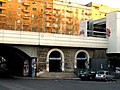 One of the entrances
 -
 Basilica San Paolo


External links[edit]
![]() Media related to Metropolitana di Roma linea B - Basilica San Paolo at Wikimedia Commons
Media related to Metropolitana di Roma linea B - Basilica San Paolo at Wikimedia Commons
This article about an Italian railway station is a stub. You can help Wikipedia by expanding it. |
This Rome Metro article is a stub. You can help Wikipedia by expanding it. |