Ampefy
Ampefy | |
|---|---|
| Coordinates: 19°02′31″S 46°43′58″E / 19.04194°S 46.73278°E | |
| Country | |
| Region | Itasy |
| District | Soavinandriana |
| Elevation | 1,288 m (4,226 ft) |
| Population (2018)[2] | |
| • Total | 19,949 |
| • Ethnicities | Merina |
| Time zone | UTC3 (EAT) |
| Postal code | 118 |
Ampefy is a municipality in Madagascar. It belongs to the district of Soavinandriana, which is a part of Itasy Region. The population of the commune was 19,949 in 2018.


Primary and junior level secondary education are available in town. The majority 91.5% of the population of the commune are farmers. The most important crops are beans and vegetables; also maize is an important agricultural product. Industry and services provide employment for 0.5% and 1% of the population, respectively. Additionally fishing employs 7% of the population.[3]
Roads[edit]
It is localized on the National Road 43.
Rivers[edit]
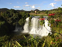
The Lily River that forms also the Lily falls near Ampefy.
Lakes[edit]
The Lake Itasy, the forth mayor lake of Madagascar, is partly situated in this municipality.
References[edit]
- ^ Estimated based on DEM data from Shuttle Radar Topography Mission
- ^ TROISIEME RECENSEMENT GENERAL DE LA POPULATION ET DE L’HABITATION
- ^ "ILO census data". Cornell University. 2002. Retrieved 2008-04-23.


