Portal:Weather
The weather portal
Weather is the state of the atmosphere, describing for example the degree to which it is hot or cold, wet or dry, calm or stormy, clear or cloudy. On Earth, most weather phenomena occur in the lowest layer of the planet's atmosphere, the troposphere, just below the stratosphere. Weather refers to day-to-day temperature, precipitation, and other atmospheric conditions, whereas climate is the term for the averaging of atmospheric conditions over longer periods of time. When used without qualification, "weather" is generally understood to mean the weather of Earth.
Weather is driven by air pressure, temperature, and moisture differences between one place and another. These differences can occur due to the Sun's angle at any particular spot, which varies with latitude. The strong temperature contrast between polar and tropical air gives rise to the largest scale atmospheric circulations: the Hadley cell, the Ferrel cell, the polar cell, and the jet stream. Weather systems in the middle latitudes, such as extratropical cyclones, are caused by instabilities of the jet streamflow. Because Earth's axis is tilted relative to its orbital plane (called the ecliptic), sunlight is incident at different angles at different times of the year. On Earth's surface, temperatures usually range ±40 °C (−40 °F to 104 °F) annually. Over thousands of years, changes in Earth's orbit can affect the amount and distribution of solar energy received by Earth, thus influencing long-term climate and global climate change.
Surface temperature differences in turn cause pressure differences. Higher altitudes are cooler than lower altitudes, as most atmospheric heating is due to contact with the Earth's surface while radiative losses to space are mostly constant. Weather forecasting is the application of science and technology to predict the state of the atmosphere for a future time and a given location. Earth's weather system is a chaotic system; as a result, small changes to one part of the system can grow to have large effects on the system as a whole. Human attempts to control the weather have occurred throughout history, and there is evidence that human activities such as agriculture and industry have modified weather patterns.
Studying how the weather works on other planets has been helpful in understanding how weather works on Earth. A famous landmark in the Solar System, Jupiter's Great Red Spot, is an anticyclonic storm known to have existed for at least 300 years. However, the weather is not limited to planetary bodies. A star's corona is constantly being lost to space, creating what is essentially a very thin atmosphere throughout the Solar System. The movement of mass ejected from the Sun is known as the solar wind. (Full article...)
Selected article

The climate of India is composed of a wide range of weather conditions across a large geographic scale and varied topography. Analyzed according to the Köppen system, India hosts six major climatic subtypes, ranging from desert in the west, to alpine tundra and glaciers in the north, to humid tropical regions supporting rainforests in the southwest and the island territories. Many regions have starkly different microclimates. The nation has four seasons: winter (January and February), summer (March to May), a monsoon season (June to September), and a post-monsoon period (October to December).
India's unique geography and geology strongly influence its climate; this is particularly true of the Himalayas in the north and the Thar Desert in the northwest. The Himalayas act as a barrier to the frigid katabatic winds flowing down from Central Asia. Thus, North India is kept warm or only mildly cold during winter; in summer, the same phenomenon makes India relatively hot. Although the Tropic of Cancer—the boundary between the tropics and subtropics—passes through the middle of India, the whole country is considered to be tropical.
As in much of the tropics, monsoonal and other weather conditions in India are unstable: major droughts, floods, cyclones and other natural disasters are sporadic, killing or displacing millions. India's long-term climatic stability is further threatened by global warming. Climatic diversity in India makes the analysis of these issues complex.
Recently selected articles: Subtropical cyclone, Precipitation, More...
Did you know (auto-generated) -

- ... that Eric Berger wrote about weather for the Houston Chronicle even before he became a certified meteorologist?
- ... that in the 1980s, "Sherman Bonner, The Human Thermometer" presented the weather on an Arkansas TV station?
- ... that the weather forecast for HD 189733 b is "Westerly winds at 2000 m/s, with molten glass showers"?
- ... that extreme event attribution estimates how much climate change causes weather events, such as the 2021 Western North America heat wave?
- ... that after Irish post office clerk Maureen Flavin Sweeney reported worsening weather conditions, Dwight D. Eisenhower agreed to postpone D-Day by 24 hours?
- ... that weather whiplash is the phenomenon of rapid swings between extremes of weather conditions?
Selected image

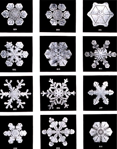
Different types of snowflakes are shown in this series of photos, taken by Wilson Bentley in 1902. The phrase "no two snowflakes are alike" is mostly based in truth, as their shape, size, and branching features are highly sensitive to the exact humidity, temperature, and other atmospheric conditions in which they form.
Recently selected pictures: Ground fog, Virga over London, Hurricane Isabel satellite, More...
More did you know...
...that the Flying river is the name given to the transport of water vapor from the Amazon rainforest to southern Brazil?
...that hurricane shutters are required for all homes in Florida unless impact-resistant glass is used?
...that the Joint Institute for Marine and Atmospheric Research is a combined weather and ocean research institute with the cooperation of the Office of Oceanic and Atmospheric Research and the University of Hawaiʻi?
...that the SS Central America was sunk by a hurricane while carrying more than 30,000 pounds (13,600 kg) of gold, contributing to the Panic of 1857?
...that a hurricane force wind warning is issued by the United States National Weather Service for storms that are not tropical cyclones but are expected to produce hurricane-force winds (65 knots (75 mph; 120 km/h) or higher)?
...that the Automated Tropical Cyclone Forecasting System is a software package for tropical cyclone forecasting developed in 1988 that is still used today by meteorologists in various branches of the US Government?
Recent and ongoing weather
- Wikinews weather portal
- March 26, 2021: Tropical moisture ceases to cause severe floods in South East Australia
- February 19, 2021: Winter storms hammer Texas, fatalities reported
- December 28, 2021: Typhoon Phanfone strikes Philippines
- February 1, 2022: Deadly floods in Brazil after heavy rainfall
- April 15, 2022: South African floods kill at least 300 people
- Weather of 2024
- 2024 Atlantic hurricane season
- 2020–21 North American winter
- 2024 Pacific typhoon season
- Tornadoes of 2024
This week in weather history...
May 21
1953: A deadly tornado killed 2 people in Port Huron, Michigan, and crossed the St. Clair River into Canada where it killed 4 more people in Sarnia, Ontario.
May 22
2011: A violent tornado killed 158 people and destroyed much of the city of Joplin, Missouri. This was the most people killed by a single tornado in the United States since the beginning of official tornado forecasts in 1950.
May 23
1995: The GOES 9 weather satellite was launched. GOES 9 would provide weather forecasting data to the National Oceanic and Atmospheric Administration until 1998, and was leased to the Japan Meteorological Agency from 2001–2003.
May 24
2006: The GOES 13 weather satellite was launched. Part of the Geostationary Operational Environmental Satellite program, GOES 13 would provide public weather forecasting data to the United States until its retirement in 2018, when it was transferred to the United States Air Force.
May 25
1989: Tropical Storm Cecil made landfall near Hội An, Vietnam, causing severe flooding that killed more than 700 people.
May 26
1972: Subtropical Storm Alpha reached peak intensity east of Savannah, Georgia, where it would make landfall the next day.
May 27
1774: Francis Beaufort, inventor of the Beaufort scale for measuring wind force, was born in Ireland.
Selected biography
Anders Celsius (Swedish pronunciation: [ˈânːdɛʂ ˈsɛ̌lːsɪɵs]; 27 November 1701 – 25 April 1744) was a Swedish astronomer, physicist and mathematician. He was professor of astronomy at Uppsala University from 1730 to 1744, but traveled from 1732 to 1735 visiting notable observatories in Germany, Italy and France. He founded the Uppsala Astronomical Observatory in 1741, and in 1742 proposed (an inverted form of) the Centigrade temperature scale which was later renamed Celsius in his honour. (Full article...)
Previously selected biographies: Robert FitzRoy, More...
Related portals
Quality content
Other candidates:
- Featured Article Review: 2005 Atlantic hurricane season (Discussion)
- Featured List Removal Candidate: List of storms in the 2005 Atlantic hurricane season (Discussion)
Subcategories
WikiProjects
The scope of WikiProject Weather is to have a single location for all weather-related articles on Wikipedia.
WikiProject Meteorology is a collaborative effort by dozens of Wikipedians to improve the quality of meteorology- and weather-related articles. If you would like to help, visit the project talk page, and see what needs doing.
WikiProject Severe weather is a similar project specific to articles about severe weather. Their talk page is located here.
WikiProject Tropical cyclones is a daughter project of WikiProject meteorology. The dozens of semi-active members and several full-time members focus on improving Wikipedia's coverage of tropical cyclones.
WikiProject Non-tropical storms is a collaborative project to improve articles related to winter storms, wind storms, and extratropical cyclones.
Wikipedia is a fully collaborative effort by volunteers. So if you see something you think you can improve, be bold and get to editing! We appreciate any help you can provide!
Associated Wikimedia
The following Wikimedia Foundation sister projects provide more on this subject:
-
Commons
Free media repository -
Wikibooks
Free textbooks and manuals -
Wikidata
Free knowledge base -
Wikinews
Free-content news -
Wikiquote
Collection of quotations -
Wikisource
Free-content library -
Wikiversity
Free learning tools -
Wiktionary
Dictionary and thesaurus


