Yount, Missouri
Yount, Missouri | |
|---|---|
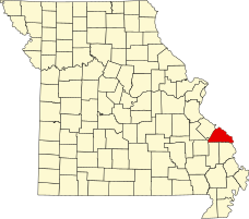
 Location of Perry County, Missouri | |
| Coordinates: 37°36′19″N 90°02′20″W / 37.60528°N 90.03889°W | |
| Country | United States |
| State | Missouri |
| County | Perry |
| Township | Saint Mary’s |
| Elevation | 623 ft (190 m) |
| Time zone | UTC-6 (Central (CST)) |
| • Summer (DST) | UTC-5 (CDT) |
| ZIP code | 63775 |
| Area code | 573 |
| FIPS code | 29-81394 [2] |
| GNIS feature ID | 753014 [1] |
Yount is an unincorporated settlement in Saint Mary's Township in Perry County, Missouri.
History[edit]
Yount was established in 1886 as Yount's Store, and was named for Henry Yount,[3] a merchant and storekeeper, as well as a postmaster and county judge. The name was shortened to Yount in 1888.[4] The post office operated in Yount from 1887 until 1954.[5]
Mt. Pisca Lutheran Church was founded in Yount in 1852 and continued until 1868. In that same year, the church became the Mt. Zion Lutheran Church which existed until 1974.
Geography[edit]
Yount is located 17 miles (27 km) southwest of Perryville, Missouri.[6]
References[edit]
- ^ a b U.S. Geological Survey Geographic Names Information System: Yount, Missouri
- ^ Yount, Missouri at RoadsideThoughts.com. Retrieved June 16, 2022.
- ^ Eaton, David Wolfe (1917). How Missouri Counties, Towns and Streams Were Named. The State Historical Society of Missouri. pp. 338.
- ^ State Historical Society of Missouri: Perry County http://shs.umsystem.edu/manuscripts/ramsay/ramsay_perry.html Archived 2016-03-31 at the Wayback Machine
- ^ Missouri Postal History http://www.missouripostalhistory.org/pe157pe.htm Archived 2013-10-21 at the Wayback Machine
- ^ A Directory of Towns, Villages, and Hamlets Past and Present of Perry County, Missouri. Retrieved June 16, 2022.

