
Wikipedia:Graphics Lab/Map workshop/Archive/Jul 2015
| This page is an archive. Do not edit the contents of this page. Please direct any additional comments to the current main page. |

Update for File:Israel Railways map 2013.svg
-
 Existing map of Israel Railways
 -
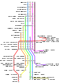 2015 updated map


- Article(s)
- Israel Railways
- Request
- The liner from Jerusalem to Tel Aviv needs to be extended to Herzliya, and the Rishon LeZion HaRishonim to Netanya - see here (the stations on the map are all labeled in English as well as Hebrew). Additionally, I suspect that the colors of the lines should probably be chaned, because they're used on the map only for the purpose of distinguishing the separate lines on the map, and they have nothing to do with reality, so copying them may be a copyvio. עוד מישהו Od Mishehu 12:04, 14 January 2015 (UTC)
- Graphist opinion(s)
- How does this look? I took some liberties with the layout to avoid angled text, which I think hurts the readability of the map. Cheers, Mliu92 (talk) 21:52, 16 April 2015 (UTC)
- @Od Mishehu: Sorry, forgot to ping you the first time I updated this. Cheers, Mliu92 (talk) 21:47, 2 July 2015 (UTC)
- @Mliu92:Actually, the lines across (where the angled text was necessary) represent lines which go East-West = for example, Jerusalem is more or less east of Beit Shemesh (and if anything, a little north, not south); and the line from the northern end of Tel Aviv to Kfar Saba goes east until past Petah Tikva, north through Rosh HaAyin, and then west to Hod HaSharon and Kfar Saba, which is approximately east of Herzliya (not Atlit). עוד מישהו Od Mishehu 10:09, 7 July 2015 (UTC)
- @Od Mishehu: Thank you, I've changed it to a new version to reflect the geography more accurately. Cheers, Mliu92 (talk) 14:47, 7 July 2015 (UTC)
- @Mliu92:Actually, the lines across (where the angled text was necessary) represent lines which go East-West = for example, Jerusalem is more or less east of Beit Shemesh (and if anything, a little north, not south); and the line from the northern end of Tel Aviv to Kfar Saba goes east until past Petah Tikva, north through Rosh HaAyin, and then west to Hod HaSharon and Kfar Saba, which is approximately east of Herzliya (not Atlit). עוד מישהו Od Mishehu 10:09, 7 July 2015 (UTC)
- @Od Mishehu: Sorry, forgot to ping you the first time I updated this. Cheers, Mliu92 (talk) 21:47, 2 July 2015 (UTC)
Map for article on King Æthelwulf of Wessex
. Many thanks again. Dudley Miles (talk) 17:46, 19 July 2015 (UTC)
-
 Map by Ikonact which I have amended
 -
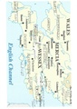 Map of southern England for article on King Æthelwulf of Wessex (839-858)
 -
 Draft of new map


- Article(s)
- Æthelwulf
- Request
- Ikonact kindly created a map for the article on King Æthelstan, and I have amended it to show the places mentioned in the article on his great-grandfather, King Æthelwulf. I hope to get the article on this important king to FA, and a map would be very helpful. Note: Sites of battles are shown with crosses, and I have shown towns in upper case for clarity but they would need to be in title case on the map. Dudley Miles (talk) 21:41, 6 July 2015 (UTC)
- Graphist opinion(s)

- @Dudley Miles: I made the map on the right some time ago and could modify it to your requirements. Let me know if it's suitable. Philg88 ♦talk
- Thanks @Philg88:. There would be substantial changes needed as the new map is for the mid-ninth century, pre-Viking, and I do not know how easy they would be. Changes are: 1. Only the southern half is relevant. 2. No map I know of for c.850 shows boundaries, presumably because they are so uncertain, so the colours and boundaries would need to be stripped out, leaving a white map. 3. Mercia would be shown across where English and Danish Mercia are now, and the Welsh sub-kingdoms deleted, leaving just Wessex, Mercia, Wales and East Anglia.
- Does that seem practical? Dudley Miles (talk) 09:25, 19 July 2015 (UTC)
- @Dudley Miles: Sounds like it would be more practical to modify the Ikonact map. Leave it with me and let me see what I can do. Cheers, Philg88 ♦talk 09:51, 19 July 2015 (UTC)
- Thanks very much Phil. Dudley Miles (talk) 10:21, 19 July 2015 (UTC)
- @Dudley Miles: Please take a look at the draft above and let me have any comments or suggestions. Philg88 ♦talk 16:03, 19 July 2015 (UTC)
- @Philg88: Thanks very much. That's brilliant. A few minor points. 1. Sorry I did not make myself clear about the forest. It should be Selwood Forest, and slightly more vertical in shape and a bit further west, on the same longitude as Sherborne. 2. I would delete Polesworth and the other northern (on this map) towns. They are not relevant to this article and I do not know whether they all existed in 850. 3. There does not seem to be room to put in Surrey, which is a pity but not crucial. Dudley Miles (talk) 16:50, 19 July 2015 (UTC)
- @Dudley Miles: New version uploaded. Please mark request as resolved if you're happy. Philg88 ♦talk 17:31, 19 July 2015 (UTC)
- @Philg88: Thanks very much. That's brilliant. A few minor points. 1. Sorry I did not make myself clear about the forest. It should be Selwood Forest, and slightly more vertical in shape and a bit further west, on the same longitude as Sherborne. 2. I would delete Polesworth and the other northern (on this map) towns. They are not relevant to this article and I do not know whether they all existed in 850. 3. There does not seem to be room to put in Surrey, which is a pity but not crucial. Dudley Miles (talk) 16:50, 19 July 2015 (UTC)
- @Dudley Miles: Please take a look at the draft above and let me have any comments or suggestions. Philg88 ♦talk 16:03, 19 July 2015 (UTC)
- Thanks very much Phil. Dudley Miles (talk) 10:21, 19 July 2015 (UTC)
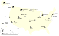
East Caucasus Map


I am trying to work up the Imam Shamil war. The best map we have is [*[file:Karte des Kaukasischen Isthmus - Entworfen und gezeichnet von J-Grassl - 1856.jpg|thumb]*], but you have to expand it to see anything. Could someone cut out the area about 41.4-44.0 N and 44.4-48.7 E (West: Vladikavkaz-Tiflis, North: Kizlar, south: southernmost Samur River) and make it a separate map? Thanks, Benjamin Trovato (talk) 00:30, 16 May 2015 (UTC)
![]() Done Maproom (talk) 20:01, 20 May 2015 (UTC)
Done Maproom (talk) 20:01, 20 May 2015 (UTC)
Could this be redone? The left side cuts off the label on Vladikazkaz which is an important location. The left edge should be moved west to include the whole northwest bulge of the Terek River to give a clear idea of the geography - near 'Jekaterinograd' or wherever makes a clean cut. This in entirely my fault. I thought I properly inspected the map before making the request, but clearly did not. Sorry. Benjamin Trovato (talk) 00:58, 25 May 2015 (UTC)
- I am not going to be able to redo this any time soon. I hope another editor can take it on. Maproom (talk) 14:21, 26 May 2015 (UTC)
- Map released as part of Murid War. Benjamin Trovato (talk) 22:39, 28 May 2015 (UTC)
- Since fix has been pending for over a month I assume you have better things to do. I respect your judgment and request this be closed. Benjamin Trovato (talk) 22:39, 8 July 2015 (UTC)
Map of the Sentinel Program
-
 A map
A map

- Article(s)
- Sentinel Program
- Request
- I'm about 1/2 way through an article on the Sentinel Program, a US anti-missile system from the late 1960s. I'd like to add a map of the deployment options. You can find the map here. It's basically a series of markings on the US map. -- Maury Markowitz (talk) 20:15, 15 July 2015 (UTC)
- Graphist opinion(s)
 Done @Maury Markowitz: There you go. Philg88 ♦talk 08:08, 19 July 2015 (UTC)
- @Philg88: Wow, superb work! Maury Markowitz (talk) 21:56, 24 July 2015 (UTC)
- Some very minor corrections? You can remove the ACC1, ACC2 and ACC3 labels. I think these were base names, but if so they would be better left somewhere else. The icons seem to be behind the geography, you can see it where the missile icons are half-on/half-off. The labels for Boston and New York at missing. Finally, the captions in the lower left should read "missiles" not "missile", they had lots at each site. Nice work on the MSR faces BTW! Maury Markowitz (talk) 22:00, 24 July 2015 (UTC)
- @Maury Markowitz: All done, please mark request as {{resolved}}, if you're happy. Philg88 ♦talk 05:36, 25 July 2015 (UTC)
- @Philg88: Very last thing, I promise - I should have noticed this the first time, there's a spelling mistake in the caption. It's "Sprint" not "Sprite". Maury Markowitz (talk) 13:54, 26 July 2015 (UTC)
- @Maury Markowitz: Sorry about that, I must have been subconsciously thirsty! New version uploaded. Cheers, Philg88 ♦talk 14:50, 26 July 2015 (UTC)
Commonwealth Map - Ghana and Pakistan

- Article(s)
- Republics in the Commonwealth of Nations
- Request
- Pakistan and Ghana are republics within the Commonwealth, so could someone please shade them in pink to reflect that. Additionally, would someone remove the border between East and West Germany, and change the transparent colour of the sea to white, please.
User: Snow Lion Fenian — Preceding unsigned comment added by 5.134.90.140 (talk) 18:00, 15 June 2015
- Graphist opinion(s)
![]() DoneMellonDor (talk) 21:20, 29 July 2015 (UTC)
DoneMellonDor (talk) 21:20, 29 July 2015 (UTC)