
Way, Mississippi
Way, Mississippi | |
|---|---|
 Way  Way | |
| Coordinates: 32°44′38″N 90°01′59″W / 32.74389°N 90.03306°W | |
| Country | United States |
| State | Mississippi |
| County | Madison |
| Elevation | 210 ft (60 m) |
| Time zone | UTC-6 (Central (CST)) |
| • Summer (DST) | UTC-5 (CDT) |
| ZIP code | 39046 |
| Area code | 601 |
| GNIS feature ID | 679398[1] |
Way is an unincorporated community located in Madison County, Mississippi. Way is approximately 9 miles (14 km) north of Canton on Way Road.
Way is located within the Jackson Metropolitan Statistical Area.
History[edit]
Way is located on the Grenada Railroad.[2] A post office operated under the name Way's Bluff from 1858 to 1895 and under the name Way from 1895 to 1968.[3]
In 1900, the community had a population of 36.[4]
The Allison's Wells Hotel—described as a stately structure with a large ballroom—was located in Way. In 1948, the Mississippi Art Colony was organized at the hotel. The hotel was destroyed by fire in 1963.[5][6]
Camp Bratton-Green and the Gray Center, both part of the Episcopal diocese, are located in Way, Mississippi.
References[edit]
- ^ U.S. Geological Survey Geographic Names Information System: Way, Mississippi
- ^ Howe, Tony. "Way, Mississippi". Mississippi Rails. Retrieved May 20, 2023.
- ^ "Madison County". Jim Forte Postal History. Retrieved May 20, 2023.
- ^ Rowland, Dunbar (1907). Mississippi: Comprising Sketches of Counties, Towns, Events, Institutions, and Persons, Arranged in Cyclopedic Form (PDF). Vol. 2. Southern Historical Publishing Association. p. 942.
- ^ Loeb, Jean (1998). "History". Mississippi Art Colony.
- ^ Perron, Michelle (November 16, 1986). "Gathering of Southern Artists Offers a Chance to Work and Learn". Spartanburg Harald-Journal.
Municipalities and communities of Madison County, Mississippi, United States | ||
|---|---|---|
| Cities | 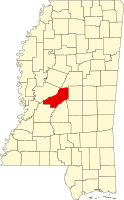 | |
| Town | ||
| CDPs | ||
| Other communities | ||
| Ghost town | ||
| Footnotes | ‡This populated place also has portions in an adjacent county or counties | |
Www.graycenter.org
This Madison County, Mississippi state location article is a stub. You can help Wikipedia by expanding it. |