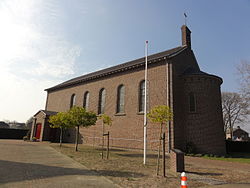
Veulen
Veulen | |
|---|---|
Village | |
 Church of Veulen | |
| Coordinates: 51°29′N 5°57′E / 51.483°N 5.950°E | |
| Country | Netherlands |
| Province | Limburg |
| Municipality | Venray |
| Area | |
| • Total | 10.29 km2 (3.97 sq mi) |
| Elevation | 29 m (95 ft) |
| Population (2021)[1] | |
| • Total | 555 |
| • Density | 54/km2 (140/sq mi) |
| Time zone | UTC+1 (CET) |
| • Summer (DST) | UTC+2 (CEST) |
| Postal code | 5814[1] |
| Dialing code | 0478 |
Veulen (Limburgs: ´t Väöle) is a village in the municipality of Venray in Limburg, Netherlands.
The village was first mentioned in 1590 as Vairloe, and probably means "open forest located in front". Even though the current name translates to calf, there is no relation.[3]
Gallery[edit]
-
School in Veulen
-
Drinking calf statue
References[edit]
- ^ a b c "Kerncijfers wijken en buurten 2021". Central Bureau of Statistics. Retrieved 26 April 2022.
- ^ "Postcodetool for 5814AA". Actueel Hoogtebestand Nederland (in Dutch). Het Waterschapshuis. Retrieved 26 April 2022.
- ^ "Veulen - (geografische naam)". Etymologiebank (in Dutch). Retrieved 26 April 2022.
Wikimedia Commons has media related to Veulen (Venray).


