
User:Dragfyre/Sandbox/Long Bien Bridge
21°2′36″N 105°51′32″E / 21.04333°N 105.85889°E

Long Bien Bridge (Vietnamese: Cầu Long Biên) is a historic cantilever bridge across the Red River that connects two parts of the city of Hanoi, Vietnam. It was originally called Paul Doumer Bridge.
a "masterpiece of French engineering".[1]
Overview[edit]
The bridge across the Red River in Hanoi—named the Doumer Bridge and now known as Long Biên—is one of most spectacular French technological masterpieces in Asia (g. 1). It symbolized the role of French engineers in the conquest of nature, especially since the Red River was known for its changing currents and ery temperament. Between 1897 and 1901, and at a cost of 6.1 million francs, the Eiffel Company drew designs and supervised the construction of the 1,668-meter-long bridge, the longest bridge that the French had built in Asia by this time (Weill 1995). Its deck rises 13 meters above water level and consists of eighteen piers separated by spans between 78 meters and 106 meters long. Its foundation descends more than 30 meters below the riverbed (Hulot and others 1990).[1]
History[edit]
Construction[edit]

It was built in 1903 by the architects of Daydé & Pillé, a French company. Before North Vietnam's independence in 1954, it was called Doumer Bridge, named after Paul Doumer - The Governor-General of French Indochina and then French president. It was, at that time, one of the longest bridges in Asia with the length of 2,500 m.[2] For the French colonial government, the construction was of strategic importance in securing control of northern Vietnam. From 1899 to 1902, more than 3,000 Vietnamese took part in the construction.
According to Doumer, the foundations were the most difcult part to construct. At 33 meters below the surface of the river, air pressure reached 3 atmospheres and was “horribly painful” for the indigenous workers the French engineers supervised, in the words of Doumer (1905, 312). The length of each shift was four hours; workers were thereafter offered a drink, medical attention, and a massage. Doumer wrote: This paternal treatment was more than one could ever imagine for [making] a good advertisement for [the job of] construction workers, and offers from workers poured in. . . . The establishment of the bridge on Hanoi denitely struck the imagination of the indigenous people. Indigenous and scientic techniques which were utilized and the result which was obtained made them aware of the benecial force of French civilization. Our scientic genius, our industrial power morally conquered the population, whose armies we have subdued. (312)[1]

The inauguration of the bridge on February 2, 1902, involved a special celebration. The emperor of Annam, Thành Thái (1879–1954, r. 1889–1907), took part in the festivities, as did Paul Beau (1857–1926), who was about to become next governor-general. The celebration involved a cavalcade of decorated carriages, a military parade, and numerous celebratory speeches.[1]
FIGURE 1 Le pont Doumer (1903; presently Long Biên), spanning the Red River in Hanoi. Paul Doumer described this bridge as a triumph of French engineering: a “weightless trellis, a lace projected into the skies.” Contemporaries, however, noticed a sharp contrast between its magnicence as a technological artifact and its modest trafc ow. Today, because the bridge was heavily bombarded during the Second Vietnam War (1959–75), only parts of the original bridge have survived. Source: A. de Berques, “Les Chemins de fer en Indo-Chine” [The railways of Indochina], La Dépêche coloniale illustrée 5 (February 28, 1905): 50.[1]
Wartime[edit]
It was heavily bombarded during Vietnam War due to its critical position (the only bridge at that time across the Red River and connect Hanoi to the main port Haiphong). The first attack took place in 1967, and the center span of the bridge was felled by an attack by 20 USAF F-105 fighter-bombers[3]. The defence of Long Bien Bridge continues to play a large role in Hanoi’s self-image and is often extolled in poetry and song. It was rendered unusable for a year when, in May 1972, it fell victim to one of the first co-ordinated attacks using laser-guided "smart bombs".
The bridge now stands like a patched-up war veteran. Some parts of the original structure remain intact, while large sections have clearly been built later to repair the holes. In this way the bridge is a strong visual expression of history. Only half of the bridge retains its original shape. A project with support and loan from the French government is currently in progress to restore the bridge to its original appearance.
Today trains, mopeds, bicycles and pedestrians use the dilapidated bridge, while all other traffic is diverted to the nearby Chuong Duong Bridge and some newly built bridges: Thanh Tri Bridge, Thang Long Bridge, Vinh Tuy Bridge, and Nhat Tan Bridge.
Under the bridge, around forty extremely poor families live in boats on the Red River, coming from many poor rural areas of Vietnam.
Reception and cultural impact[edit]
Doumer proudly stated that the realization of the bridge made the local population believe that “the French do everything they want”; the local population now comprehended that “denitely, the French were more powerful, more knowledgeable than one could believe” (312). The history of the Doumer Bridge reveals how the aesthetic appeal of technology shaped the blueprints of the railways. From the beginning, Doumer dreamed of constructing a bridge that would “attract the attention of the world” and would show how French engineers had successfully overcome the challenges of the local environment. Doumer poetically described the effects of his bridge on reordering the colonial landscape: “At a close look, this steel snake was tremendous. Its length appeared indenite. But when . . . one looked at the bridge in its unity, it was only a weightless trellis, a lace projected into the skies” (1905, 312–13). His metaphor shows how the bridge came to be dened as a work of art.[1]
Images of the Doumer Bridge were numerous in the French press (de Berques 1905; “Colonies Françaises Indo-Chine” 1902; G. S. 1902). The journal La Dépêche coloniale illustrée [The illustrated colonial dispatch] devoted the entire February 1905 issue to railway construction in Indochina, and, in particular, the new bridge, where a close shot conveys its powerful appeal (52). Describing its appearance in detail, the article described the cantilever of the bridge as “the new Colossus of Rhodes”: if the Red River were to dry up, the supports of the bridge would appear as nine giants, each with a height of 61 meters. The new bridge connected regional railways with the train station in Hanoi; the train station now linked Hanoi with Hải Phòng, Lào Cai, and the province of Yunnan. Hanoi tramways also used the bridge. The Exhibition of Hanoi also celebrated the construction of the bridge and railways in Indochina (Vann 2004). Opening on November 3, 1902, a few months after the inauguration of the bridge, the exhibition marked the achievements of French colonial rule in Indochina, highlighted the accomplishments of Doumer’s administration, and acknowledged the positive role of nancial loans to Indochina in transforming the colony. The exhibition also celebrated railways: maps and photographs describing railway construction were placed in several special galleries (“Exposition de Hanoi” 1902). The exhibition sought to redene the perceptions and meanings of colonial space and to emphasize the role of railways in colonization. The Doumer Bridge passed into legend for generations of French. Implicitly and explicitly, the imagery of the bridge and new railways were intended for a French audience because the photographs of the bridge were distributed in France through the media of photographs in illustrated magazines and memoirs of engineers and travelers. For French writer and dramatist Eugène Brieux (1858–1932), in his Voyages aux Indes et en Indo- Chine: Simples notes d’un touriste (Travels in the Indies and Indochina: Unpretentious notes of a tourist), the bridge appeared so gigantic, so long, that Brieux believed its length was several kilometers (1910, 37). The architecture struck him as “bizarre and bold”; using a poetic metaphor, Brieux described the arcs of the bridge as “protruding their enormous curves against surprised sky” (37). Henriette Celarié, who undertook a voyage to Indochina in the late 1930s and subsequently published her travel notes, included an account of the construction of the bridge (1937, 156–58). She integrated excerpts from Doumer’s memoirs into her book because the story of the bridge—as Doumer told it in his memoirs—had become a part of contemporary travel narratives. According to Celarié, an old Vietnamese (Annamite in the text) compared the Red River with a sleeper “who constantly dgets in his bed.” The “rage” of the river along with its oods and changing currents made the construction of the bridge challenging. These metaphors and comparisons suggest that the construction of the bridge paralleled the epic of the conquest of Asia by the Europeans.[1]
The same paradox rings true for the Doumer Bridge across the Red River: There was a dramatic contradiction between its symbolic value and its practical use as the hub for railway activity in Southeast Asia. In terms of functionality, the bridge was hardly effective. In his Voyages aux Indes et en Indo-Chine, Brieux (1910) noticed a perplexing thing about the bridge: It had just a single set of tracks, only two sidewalks for pedestrians, and no line for vehicles. Brieux highlighted a contrast between the extraordinary appearance of the gigantic bridge and its rather petty role in fullling regional transportation needs: It is with the greatest surprise I noticed that this enormous bridge carries just one line. . . I could not believe my eyes then. How could one spend a considerable sum of money which it [the bridge] cost to achieve no more than this petty result. . . ? If one did not believe in the future of Hanoi, [the bridge] was super uous. If one did believe in it, then it was insufcient. (37) Those who traveled by car or rickshaw and who wished to cross the river had to make a detour and to take a ferry, as was done one hundred years earlier. Brieux also suggested that, while resorting to the ferry, passengers looked at the gigantic bridge not without sadness and disappointment.[1]
Image gallery[edit]
-
 Closeup of the iron beams
 -
 Closeup of the iron beams
 -
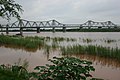 Long Bien Bridge seen from the Red River
 -
 Sunset over the Red River from the bridge


References[edit]
- ^ a b c d e f g h Engineering the Empire of Images: Constructing Railways in Asia before the Great War. Natalia Starostina. Southeast Review of Asian Studies, Volume 31 (2009), pp. 181–206.
- ^ Vietnam News Agency (VNA)
- ^ Sources: 388th TFW official history & Rolling Thunder Digest (CINCPAC) Edition Five, Jul-Sep 1967
External links[edit]
![]() Media related to Dragfyre/Sandbox/Long Bien Bridge at Wikimedia Commons
Media related to Dragfyre/Sandbox/Long Bien Bridge at Wikimedia Commons