
User:Ayanosh/sandbox
| This is not a Wikipedia article: It is an individual user's work-in-progress page, and may be incomplete and/or unreliable. For guidance on developing this draft, see Wikipedia:So you made a userspace draft. Find sources: Google (books · news · scholar · free images · WP refs) · FENS · JSTOR · TWL |

Flora and fauna[edit]
The Lakshadweep Archipelago forms a terrestrial ecoregion together with the Maldives and the Chagos.[1] It has over 600 species of marine fishes, 78 species of corals, 82 species of seaweed , 52 species of crabs , 2 species of lobsters, 48 species of gastropods, 12 species of bivalves, 101 species of birds.[2] It is one of the four coral reef regions in India.[3] The corals are a major attraction for the tourist. Pitti Island, is an important breeding place for sea turtles and for a number of pelagic birds such as the Brown Noddy (Anous stolidus), Lesser Crested Tern (Sterna bengalensis) and Greater Crested Tern (Sterna bergii).[4] The island has been declared a bird sanctuary.[5]
The region does not have a rich flora and almost all the plants can be found on the mainland of India.There is also an absence of forest in the region.Nearly 400 species of plants have been documented including Cymodocia isoetifolia, Syringodium isoetifolium, Thalassia hemprichii, Pandanus, Heliotropium foertherianum, Tournefortia argentea and Pemphis acidula other plant groups such as angiosperms, fungi, algae, lichens are also found.The common flora of the coral sands include coconut groves, the three species of sea grasses Pemphis acidula, Cordia subcordata, Scaevola taccada, Thespesia populnea, Suriana maritime, Dodonaea viscosa, Guettarda speciosa, seaweeds such as Enteromorpha, Ulva, Codium, Hypena.[2][6]
Ecology[edit]
The Lakshadweep Archipelago forms a terrestrial ecoregion together with the Maldives and the Chagos.[1] The Lakshadweep lagoons, reefs and banks are very rich in marine species with many types of living corals, sea urchins, seaweeds, sea cucumbers, starfish, cowry, clams and octopus. There are also many types of fish, such as butterfly fish, moray eels and the lagoon triggerfish. Uninhabited atolls like Cherbaniani, Byramgore Reef and Perumal Par, as well as Pitti Island, are important breeding places for sea turtles and for a number of pelagic birds such as the Brown Noddy (Anous stolidus), Lesser Crested Tern (Sterna bengalensis) and Greater Crested Tern (Sterna bergii).[4] Different species of tuna, wahoo and swordfish, as well as dolphins, are common in the pelagic waters off the islands.
Owing to the wealth of marine life surrounding Suheli Par there was a proposal to declare the waters of this atoll a Marine National Park.[7]
Native flora include small trees and bushes typical of littoral zones, such as Pandanus, Heliotropium foertherianum, Scaevola taccada, Tournefortia argentea and Pemphis acidula.[6]
Native flora include small trees and bushes typical of littoral zones, such as Pandanus, Heliotropium foertherianum, [], Tournefortia argentea and Pemphis acidula.
l[edit]
Lakshadweep /ləkˈʃ[invalid input: 'ah']dw[invalid input: 'ee']p/ (ⓘ, Lakshadīb), formerly known as the Laccadive, Minicoy, and Amindivi Islands /ˌlækəd[invalid input: 'eye']v ˌmɪn[invalid input: 'i-']kɔɪ[invalid input: 'and']ˌæm[invalid input: 'i-']nˈd[invalid input: 'ee']vi/,[8] is a group of islands in the Laccadive Sea, 200 to 440 km off the South Western coast of India.The archiplego is a Union Territory and is governed by the Union Government of India. They were also known as Laccadive Islands, although geographically this is only the name of the central subgroup of the group. Lakshadweep comes from "Lakshadweepa", which means "one hundred thousand islands" in Malayalam.[9][10] The islands form the smallest Union Territory of India: their total surface area is just 11 sq mi or 32 km2. The lagoon area covers about 4,200 square kilometres (1,600 sq mi), the territorial waters area 20,000 square kilometres (7,700 sq mi) and the exclusive economic zone area 400,000 square kilometres (150,000 sq mi).The region forms a single Indian district with ten Sub divisions.Kavaratti serves as the capital of the Union Territory and the region comes under the jurisdiction of Kerala High Court.
As the islands do not have any aboriginal groups, different views have been postulated by the scholars about the history of habitation on these islands.Archaeological evidence support the existence of human settlement in the region around 1500 BC.The islands have been known to the sailors since early historical period with a 1st century CE reference of the region in Periplus of the Erythraean Sea, by an anonymous author.The islands wind reference in the Buddhist Jataka stories of the 6th century BCE.Muslim missionaries around 7th century led to the advent of Islam in the region.During the medieval period the region was ruled by the cholas,Cannanore kingdom.The Portugese arrived aound1298 and were upstaged by 1545.The region was then ruled by Muslim house of Arakkal, followed by Tipu Sultan.On his death in 1799 most of the region passed on to the British and with their departure the Union Territory was formed in 1956.
Ten of the islands are inhabited. As per the 2011 Indian census the populaion of the Union Territory is 64,429.Majority of the indigenous population is Muslim and most of them belong to the Shafi School of the Sunni Sect.Th islanders are ethnically similar to the Malayali people of the nearest Indian state of Kerala.Most of the population speaks Malayalam with Mahi (or Mahl) being the most spoken language in Minicoy island.The islands are served by an airport on the Agatti island.Tha main occupation of the people is Fishing and coconut cultivation with tuna being the main item of export.
Laks references[edit]
The islands are the northernmost of the Lakshadweep-Maldives-Chagos group of islands, which are the tops of a vast undersea mountain range, the Chagos-Laccadive Ridge. [12]
Uttarakhand/ˌ[invalid input: 'ʉ']tərɑː khənd/ (Sanskrit: उत्तराखण्डम्, Uttarākhanḍam, Hindi: उत्तराखण्ड, Uttarākhanḍ), formerly Uttaranchal, is a state in the northern part of India. It is often referred to as the "Land of the gods" (Hindi: देव भूमि, Dēv bhūmi) due to the many holy Hindu temples and pilgrimage centres found throughout the state. Known for its natural beauty and wealth of the Himalayas, the Bhabhar and the Terai, the state was carved out of the Himalayan and adjoining north-western districts of Uttar Pradesh on 9 November 2000, becoming the 27th state of the Republic of India.[13] It borders the Tibet Autonomous Region on the north, the Mahakali Zone of Far-Western Region, Nepal on the east and the Indian states of Uttar Pradesh to the south and Himachal Pradesh to the north west.The state is divided into two divisions Kumaon and Garhwal with a total of 13 districts.The provisional capital of Uttarakhand is Dehradun, which is also a rail-head and the largest city in the region.The high court of the state is in Nainital.
Archaelogical evidence support the existence of humans in the region since prehistoric times.Among the first major dynasties of Garhwal and Kumaon were the Kunindas in the 2nd century BCE who practised an early form of Shaivism.Ashokan edicts at Kalsi show the early presence of Buddhism in this region.During the medieval period the region was consolidated under the Kumaon and Garhwal kingdom.By 1803 the regions fell to the Gurkha Empire of Nepal and with the conclusion of the Anglo-Nepalese War in 1816 most of today's Uttarakhand ceded to the British as part of Treaty of Sugauli.Although the erstwhile hill kingdoms of Garhwal and Kumaon were traditional rivals, the proximity of different neighbouring ethnic groups, the inseparable and complementary nature of their geography, economy, culture, language, and traditions created strong bonds between the two regions which further strengthened during the movement for statehood in the 90s.
The natives of the state are generally called either Kumaoni or Garhwali depending on their place of origin in either the Garhwal or the Kumaon region.According to the 2011 census of India Uttarakhand has a population of 10,116,752 being the 19th most populous state in India.A large portion of the population is Rajput and Brahmin.More than 8o% of the population is Hindu.Muslims are the largest minority in the state with Sikhs, Christians, Buddhists and Jains being the other major religions.Garhwali and Kumaoni are the two main regional languages with Hindi being the most widely spoken langusge.
The state is home to some the most important shrines of Hinduism giving it the moniker, Dev Bhumi.Two of the most important rivers in Hinduism originate in the religion, Ganga at Gangotri and Yamuna at Yamunotri.These two along with Badrinath and Kedarnath form the Chota Char Dham, a holy pilgrimage for the Hindus.Due to the Himalayas the state is home to some of the most beautiful hill stations in India including Nainital and Mussoorie.The state also hosts the Bengal Tiger in the Jim Corbett National Park, the oldest on the Indian sub continent.There is also the Unesco World Heritage Site of Valley of Flowers known for the variety of flowers and plants found here some of which are extremely rare.
new[edit]
rivers: Ganga, Yamuna history of region (not state only): 1 para tourism like hill stations population: ethnicity of people stats like area; no. of districts; Garhwal, Kumaon division names
Entertainment industry[edit]
Although the entertainment industry of Uttarakhand is in its infant stage, yet there is a rapid growth in terms of audio visual entertainment. The pure folk seems to be disappearing from villages, so is the younger generation. Still there are many options one can get close to the folk music. Recently, in the honor of all who gave Bedupako Baramaasa folk tune an international fame and also to make Uttarakhand folk available all around the world 24X7, an online radio, which is one of the only and very first on-line radio of Uttarakhand available on web, was created by the name of bedupako.
The State has many natural lakes at elevations from 1500 to 4500 m. The Kumaon region is particularly known as the "Lake District of India" for its large number of lakes.[14]
- http://uk.gov.in/files/pdf/Uttarakhan_at_a_Glance_2011-12.pdf
- http://www.censusindia.gov.in/2011-prov-results/data_files/india/Final_PPT_2011_progresstables.pdf
- http://planningcommission.nic.in/plans/stateplan/present/Uttarakhand.pdf
- http://media.lonelyplanet.com/shop/pdfs/470-Trekking_in_the_Indian_Himalaya_-_Uttarakhand__Chapter_.pdf
- http://books.google.co.in/books?id=XTfmGNfaoC4C&pg=PA188&lpg=PA188&dq=uttarakhand+phonetic+name&source=bl&ots=Bh5OqEDHrK&sig=XwWOHOVmI6nXZvTskGEEb47lPt0&hl=en&sa=X&ei=fkr5T6yMHsLjrAfPl5zCBg&ved=0CFcQ6AEwCQ#v=onepage&q&f=false
- http://books.google.co.in/books?id=iojJb5EjjaUC&pg=PA119&lpg=PA119&dq=uttarakhand+phonetic+name&source=bl&ots=KJn9yfTtUp&sig=ESury1VJ9CVH0oAv2jKE1aEnphM&hl=en&sa=X&ei=fkr5T6yMHsLjrAfPl5zCBg&ved=0CEMQ6AEwAA#v=onepage&q&f=false
- http://www.cleangangaportal.org/sites/default/files/user_attachements/Impacts%20of%20River%20Rafting%20on%20the%20Ganges.pdf
- http://www.tropentag.de/2007/abstracts/full/243.pdf
- http://books.google.co.in/books?id=jSelsX-adscC&pg=PA56&dq=uttarakhand+flora+fauna&hl=en&sa=X&ei=XXr6T-K1K4bMrQe12uXKBg&ved=0CFgQ6AEwBg#v=onepage&q=uttarakhand%20flora%20fauna&f=false
- http://books.google.co.in/books?id=ct6YMRvYJQ4C&pg=PA277&dq=uttarakhand+flora+fauna&hl=en&sa=X&ei=XXr6T-K1K4bMrQe12uXKBg&ved=0CFIQ6AEwBQ#v=onepage&q=uttarakhand%20flora%20fauna&f=false
- http://www.pppinindia.com/infrastructure-uttaranchal.php
- http://www.nhai.org/statewise1.asp
Gallery[edit]
-
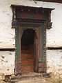 Sculpted door, Uttarakhand, India
 -
 Tungnath idol being taken up to the temple, Uttarakhand
 -
![Ruskin Bond]]](//upload.wikimedia.org/wikipedia/commons/thumb/5/52/Ruskin_Bond_1.jpg/120px-Ruskin_Bond_1.jpg) Ruskin Bond]]
Ruskin Bond]] -
 Rajendra Pachauri - WEF 2008
 -
 World's largest Buddha Stupa in Mindroling Monastery
 -
 Prasoon Joshi,a prominent Indian poet and lyricist
 -
 A typical home, in Ransi village, in Garhwal, Uttarakhand
 -

-
 Woman from Than Gaon in Uttarakhand, with two goat kids
 -

-
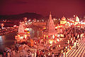 Evening prayers at Har ki Pauri in Haridwar, one of the most sacred cities of Hinduism
 -
 A stone sculpture (Mahabalipuram, Tamil Nadu) depicting Bhagiratha in penance for the salvation of 60,000 of his ancestors
 -


![Ruskin Bond]]](/wiki/File:Ruskin_Bond_1.jpg)


History[edit]

The mountains of the region have been inhabited by humans since prehistoric times shown by the ancient rock paintings, rock shelters, Paleolithic stone tools (hundreds of thousands of years old), and megaliths.There are also archaeological remains which show the existence of early Vedic (c. 1500 bce) practices in the area.[15] The Pauravas, Kushanas, Kunindas, Guptas, Gurjara-Pratihara, Katyuris, Raikas, Palas, the Chands, and Parmaras or Panwars, Sikhs and the British have ruled Uttarakhand in turns.[16] The region was originally settled by Kols, an aboriginal people of the austro- Asiatic physical type who were later joined by Indo-Aryan Khas tribes that arrived from the northwest by the Vedic period(1700-1100 BCE). At that time, present-day Uttarakhand also served as a haunt for Rishis and Sadhus. It is believed that Sage Vyasa scripted the Mahabharata here as the Pandavas are believed to have traveled and camped in the region.Among the first major dynasties of Garhwal and Kumaon were the Kunindas in the 2nd century B.C. who practiced an early form of Shaivism. They traded salt with Western Tibet. It is evident from the Ashokan edict at Kalsi in Western Garhwal that Buddhism made inroads in this region. Folk shamanic practices deviating from Hindu orthodoxy also persisted here. However, Garhwal and Kumaon were restored to nominal Brahmanical rule due to the travails of Shankaracharya and the arrival of migrants from the plains. Between the 4th and 14th centuries, the Katyuri dynasty of Khas origin dominated lands of varying extent from the Katyur (modern day Baijnath) valley in Kumaon. The historically significant temples at Jageshwar are believed to have been built by the Katyuris and later remodeled by the Chands. Other peoples of the Tibeto-Burman group known as Kiratas are thought to have settled in the northern highlands as well as in pockets throughout the region, and believed to be the ancestors to the modern day Bhotiya, Raji, Buksha, and Tharu peoples.[17]

By the medieval period, the region was consolidated under the Garhwal Kingdom in the west and the Kumaon Kingdom in the east. From the 13th–18th century, Kumaon prospered under the Chand Rajas who had their origins in the plains of India. During this period, learning and new forms of painting (the Pahari school of art) developed.[18] Modern-day Garhwal was likewise unified under the rule of Parmar/Panwar Rajas, who along with a mass migration of Brahmins and Rajputs, also arrived from the plains.[19] In 1791, the expanding Gurkha Empire of Nepal, overran Almora, the seat of the Kumaon Kingdom. In 1803, the Garhwal Kingdom also fell to the Gurkhas. With the conclusion of the Anglo-Nepalese War in 1816, a rump portion of the Garhwal Kingdom was reestablished from Tehri, and eastern British Garhwal and Kumaon ceded to the British as part of the Treaty of Sugauli.

In the post-independence period, the Garhwal Kingdom was merged into Uttar Pradesh state, where Uttarakhand composed the Garhwal and Kumaon Divisions.[20] Until 1998, Uttarakhand was the name most commonly used to refer to the region, as various political groups including most significantly the Uttarakhand Kranti Dal (Uttarakhand Revolutionary Party est. 1979), began agitating for separate statehood under its banner. Although the erstwhile hill kingdoms of Garhwal and Kumaon were traditional rivals with diverse lingual and cultural influences due to the proximity of different neighbouring ethnic groups, the inseparable and complementary nature of their geography, economy, culture, language, and traditions created strong bonds between the two regions.[21] These bonds formed the basis of the new political identity of Uttarakhand, which gained significant momentum in 1994, when demand for separate statehood (within the Union of India) achieved almost unanimous acceptance among the local populace as well as political parties at the national level.[22] Most notable incident during this period was the Rampur Tiraha firing case on the night of 1 October 1994, which led to public uproar.[23] On 24 September 1998 Uttar Pradesh Legislative Assembly passed the 'Uttar Pradesh Reorganisation Bill', 1998, which eventually led to the creation of the state,[24] eventually the Parliament passed the Indian Federal Legislation - Uttar Pradesh Reorganisation Act 2000, and thus on 9 November 2000,[25] Uttarakhand became the 27th state in the Republic of India.
Economy[edit]

Like most of India, agriculture is one of the most significant sectors of the economy of Uttarakhand.Rice, wheat, soybean, groundnut coarse cereals, pulses, oil seeds, are the most widely grown crops of the state.Fruits like apple, orange, pear, peach and plum are grown widely in the state giving immense opportunity for food processing industry.The state is one of the largest producers of seasonal fruits like Litchi, Apple, Plum, Peach, etc and premium quality basmati rice.Agro food processing is one of the most important industries of the state. To boost the agro food processing industries agri exports zones have been setup in the state for leechi, horticulture, herbs, medicinal plants and basmati rice.During the year 2010 the wheat production was 831 thousand tonnes and rice production was 610 thousand tonnes.The main cash crop pf the state, sugarcane had a production of 5058 thousand tonnes for the year 2010.As 90% of the state is hilly the yield per hectare is not very high.86% of the gross cropped area is in the plains while the remaining is from the hills.[26]
| Net State Domestic Product at Factor Cost at Current Prices (2004–05 Base)[27]
figures in crores of Indian Rupees | |
| Year | Net State Domestic Product |
|---|---|
| 2004–2005 | 22,301 |
| 2005–2006 | 26,856 |
| 2006–2007 | 32,728 |
| 2007–2008 | 40,338 |
| 2008–2009 | 46,587 |
| 2009–2010 | 54,435 |
During 2005-2006, the state successfully developed three Integrated Industrial Estates (IIEs) at Haridwar, Pantnagar and Sitarganj, Pharma City at Salequi, Information Technology Park at Sahastradhana (Dehradun), and Growth centre at Siggadi (Kotdwar). In 2005-2006. 20 private/joint/co-operative sector industrial sectors in public private partnership mode were also developed in the state.[28] Tourism, Agro and food processing and hydropower are some of the key industries of the state alongwith prospective development in IT, ITES, biotechnology, pharmaceuticals and automobiles.The service sector of Uttarakhand mainly includes tourism, information technology, higher education and banking.[26]
Uttarakhand is one of the fastest growing states in India.The Gross State Domestic Product (GSDP) (at current prices) has almost doubled from Rs 20,438 crore in FY04 to Rs 40,159 crore in FY09. The real GSDP grew around 9% (average) during FY2004‐FY2009 period.The contribution of services sector in the GSDP of Uttarakhand was around 50% during FY2001‐09.Per capita income of Uttarakhand is Rs 42,031 (FY2010) which is slightly lower than national average of Rs 44,345 (FY2010).[26] According to the Reserve Bank of India the total Forest Direct Invest ment in the state from April 2000 to October 2009 amounted to US$46.7 million.[29]
new[edit]
http://des.uk.gov.in/files/pdf/Uttarakhan_at_a_Glance_2011-12.pdf
hand: The State Profile PHD Research Bureau 10 1. Structure of the economy Uttarakhand is one of the fastest growing states in India. The state’s economy has shown a healthy growth path during the recent years. GSDP (at current prices) has almost doubled from Rs 20,438 crore in FY04 to Rs40159 crore in FY09. The real GSDP grew around 9% (average) during FY2004‐FY2009 period. Growth of Real GSDP from FY2004 to FY2009 0 2 4 6 8 10 12 14 FY04 FY05 FY06 FY07 FY08 FY09 Source: PHD Research Bureau, Compiled from Directorate of Economics and Statistics Uttarakhand Tertiary sector contributes around 49% in GSDP followed by the secondary and primary sectors at 35% and 17% respectively in FY2009. Share of secondary sector in the GSDP has also shown excellent growth, it has grown from 22% in FY2001 to 34% in the FY2009. However, the share of primary sector has come down from 28% to 17% during the same period. State Domestic Product and its Composition Source: PHD Research Bureau, Compiled from Directorate of Economics and Statistics Uttarakhand.
- Primary Sector includes Agriculture, Forest & Logging, Fishing and Mining & Quarrying
- Secondary Sector includes Manufacturing, Construction, Electricity, Gas & Water Supply.
- Tertiary Sector includes Transport, Storage & Communication, Trade, Hotel & Rest, Banking & Insurance, Real Estate,
- Secondary Sector includes Manufacturing, Construction, Electricity, Gas & Water Supply.
Ownership of Dwelling & Business Services, Public Administration and other services. Components FY01 FY05 FY09 GSDP at Current prices (Rs Crore) 14501 23720 40159 NSDP at Current Prices (Rs Crore) 12879 20794 35048 Economic Growth % (GSDP at factor cost, constant prices) 11.84 12.99 8.67 Sectoral Contribution in GSDP at current prices (%) Primary* 28.75 23.67 17.28 Secondary** 22.12 26.45 34.88 Tertiary*** 49.95 49.88 49.61Uttarakhand: The State Profile PHD Research Bureau 11 Summary of socio‐economic indicators State Capital Dehradun Area (Sq. km) 53,483 Sq KM Population (Census 2011) 1.01 Crore Population Density(Sq. Km) Census 2011 189 No. of Districts 13 Important Rivers Ganga and Yamuna Mountains The Great Himalayas GSDP at Current Prices (2008‐09) 40,159 crore Growth of GSDP at Constant Prices(FY2008‐09) 8.67% Per capita GSDP (2009‐10) Rs 42,031 Fiscal Deficit (FY12)* 3.18% of GSDP Poverty (FY2004‐05) 39.60% National Highway length (2009‐10) 1375 Kms. Rail Length (2005‐06) 345 Kms. Domestic Airport Dehradun, Pant Nagar Govt. Medical Institutions (2009‐10) 3236 Per Capita Health Expenditure (2004‐05) Rs. 818 Literacy Rate (2011 Census)** 79.6 Sex Ratio (2011 Census) 963 Key Industries Tourism, Agro and food processing and hydropower Prospective Industries IT, ITES, Biotechnology, Pharmaceuticals and Automobiles. Main Industrial Cities Haridwar, Pantnagar, Sitarganj and Dehradun Investment environment 2 nd rank Composite ranking of the state 11 th rank Agriculture 11 th rank Macro economy 12 th rank Labour laws (2009) 15th rank Infrastructure 18 th rank Source: PHD Research Bureau, Compiled from Directorate of Economics and Statistics Uttarakhand, RBI, Economic Survey of India 2010, India Today, 29 th Nov 2010, an article by Bibek Debroy and Laveesh Bhandari, Economic Freedom of the States of India 2011, by Laveesh Bhandari, Bibek Debroy and Swaminathan Aiyar and Annual report to people on health 2010.
- Advance estimates, ** Literacy rate for population aged 7 years and above.Uttarakhand: The State Profile
PHD Research Bureau 12 . Composite Ranking of the state Uttarakhand stands 11 th on the basis of various socio economic parameters viz. macro economy, investment environment, infrastructure, agriculture, primary education and consumer markets. Composite Ranking of the state 0 5 10 15 20 25 Himachal Pradesh Punjab Tamil Nadu Kerala Gujrat Haryana Karnataka Jammu & Kashmir Maharashtra Andhra Pradesh Uttarakhand Rajasthan West Bengal Madhya Pradesh Orissa Uttar Pradesh Chhatisgarh Assam Jharkhand Bihar Source: PHD Research Bureau, Compiled from India Today, 29 th Nov 2010, an article by BIbek Debroy and Laveesh Bhandari Note: Only big states have been taken up with area over 35000 sq. km. and with population over five million. The state has been ranked 2nd in industrial investments, 3rd in primary education, 6 th in Health Services, 10 th in the consumer markets, 11 th in agriculture, 12 th in macro economy and 18 th in Infrastructure. Socio‐economic ranking of the state 0 2 4 6 8 10 12 14 16 18 20 Infrastructure Macro Economy Agriculture Consumer Markets Health Services Primary Education Industrial Investment Source: PHD Research Bureau, Compiled from India Today, 29 November 2010, an article by Bibek Debroy and Laveesh Bhandari. Chart depicting area with highest rank to the lowest rankUttarakhand: The State Profile PHD Research Bureau 13 The state has been ranked 20 th in terms of size, 19 th in overall economic freedom, 14 th in legal system and 15 th in labour regulations. Comparison of Uttarakhand with other states (2009) 0 5 10 15 20 25 Bi har Uttar akhand Assam Or i ssa Chhati sgar h West Bengal Uttar Pr adesh Kar nataka Punj ab M ahar ashtr a Ker al a Jammu & Kashmi r Jhar khand Raj asthan M adhya Pr adesh Hi machal Pr adesh Har yana Andhr a Pr adesh Guj r at T ami l Nadu Source: PHD Research Bureau, Compiled from Economic Freedom of the States of India 2011, by Laveesh Bhandari, Bibek Debroy and Swaminathan Aiyar. Competitiveness ranking of the state Among the 14 smaller states of India 1 , Uttarakhand ranks 5 th in the overall competitiveness ranking of the states. Uttarakhand has been ranked 3 rd in terms of its economic strength and 7 th in infrastructure. Uttarakhand has been ranked 9 th in terms of its business efficiency, governance quality & human resource. Per‐capita income Per capita income of Uttarakhand is Rs42031 (FY2010) which is slightly lower than national average of Rs44,345 (FY2010). According to the latest 2 comparable data (FY2008), Uttarakhand is ranked at the 12 th position in terms of per capita income among all the Indian states. 1 Compiled from State competitiveness report 2004 by National Productivity Council. 2 Latest Comparable data of states available for 2008, economic survey Govt. of India 2010‐11Uttarakhand: The State Profile PHD Research Bureau 14 Pattern of per‐capita income of the Indian states (FY 2008) 0 20000 40000 60000 80000 100000 120000 Bihar Uttar Pradesh Madhya Pardesh Manipur Jharkhand Assam Rajasthan Jammu & Kashmir Orissa Mizoram Tripura Arunachal Pradesh Chhatisgarh Meghalaya West Bengal Sikkim Uttarakhand Andhra Pradesh Karnataka Himachal Pradesh Tamil nadu Kerala Gujrat Punjab Maharashtra Haryana Delhi Goa Source: PHD Research Bureau, compiled from economic survey of India 2010‐11. Fiscal Deficit Gross fiscal deficit of Uttarakhand as percentage of GSDP has declined to 3.3% during FY 2011 as compared to the 8.3% in FY2010. Primary deficit as percentage of GSDP has declined from 5.1% to 0.3% during the same period. The revenue deficit has also declined from 2.4% in FY2010 to ‐0.3% of GSDP during 2011. Primary Revenue Balance has declined to ‐3.2% from ‐0.8% of GSDP during the same period. Fiscal Indicators (% of GSDP) Fiscal components FY2005‐ 08 (Average) FY2009 FY2010(RE) FY2011(BE) GFD/GSDP 4.9 4.6 8.3 3.3 RD/GSDP ‐1.4 ‐0.6 2.4 ‐0.3 PD/GSDP 1.9 1.6 5.1 0.3 PRB/GSDP ‐4.5 ‐3.5 ‐0.8 ‐3.2 Source: PHD Research Bureau, Compiled from RBI. RD: Revenue Deficit, GFD: Gross Fiscal Deficit, PD: Primary Deficit, PRB: Primary Revenue Balance. BE: Budgeted Estimates, RE: Revised Estimates, (‐) sign refers to surplus. Comparison of fiscal position with other states Gross fiscal deficit of Uttarakhand is lower as compared to states like Punjab, Haryana and Gujrat and higher than newly formed states Chhattisgarh and Jharkhand.Uttarakhand: The State Profile PHD Research Bureau 15 Comparison of Gross Fiscal Deficit as a % of GSDP (FY2011) 0 2 4 6 8 10 12 Jharkhand Mizoram Arunachal Pradesh Maharashtra Bihar Chhattisgarh Meghalaya Andhra Pradesh Karnataka Uttarakhand Orissa Nagaland Manipur Gujrat Rajasthan Kerala Haryana Punjab Tamil Nadu Madhya Pradesh Uttar Pradesh Jammu & Kashmir West Bengal Himachal Pradesh Goa Tripura Assam Sikkim Source: PHD Research Bureau, compiled from RBI. Industrial Investments Uttarakhand is the second fastest mover in the conducive investment environment. It has attracted industrial investment proposals of more than Rs31000 crore in the last four years. The state has been able to develop three Integrated Industrial Estates at Haridwar, Pantnagar and Sitarganj, one Pharma city at Salequi and an IT park at Dehradun in a short span of ten years. Investment opportunities in Uttarakhand Agro based industry & food processing Conducive state policy and availability of large number of seasonal fruits make Uttarakhand one of the best locations to set up Agro & food processing industry. Four Agri export zones have been developed in the state. Information Technology State government is highly focused on developing IT Infrastructure in state and with IT park coming up in Dehradun, it provides ample investment opportunities in the IT industry Floriculture and Horticulture Uttarakhand spans across almost all the different agro‐geo climatic zones making it particularly conducive for growing a wide range of fruits and flowers commercially. Floriculture and horticulture are emerging as ideal areas of investment and are being developed in a big way in Uttarakhand.Uttarakhand: The State Profile PHD Research Bureau 16 Pharmaceuticals and Biotechnology Uttarakhand has one of the country’s largest Pharma city located at Salequi. State government has a vision that biotechnology is poised to make significant contributions in agriculture, human and animal health care, environment management and process industries. A biotechnology park is being developed near Pantnagar to integrate resources and to provide a focused institutional set up for accelerated commercial growth of biotechnology and bio‐Informatics in Uttarakhand. Power Tariffs The Average rate of electricity for domestic 3 consumers stands at 218.75 Paise/kwh which is lower than most other states in India. The rate for Industrial 4 consumer stands at 390.48 Paise/kwh, which is also a relatively low rate in comparison with other states of India. Hydropower Uttarakhand has huge potential for generating hydropower; nearly 15000 MW of hydropower can be generated in the state. The government has identified 47 small hydro sites (upto 25 MW) for allotment to the private sector,17 major hydro sites (25‐100 MW) have also been taken up for development. Tourism Tourism industry has been accorded the status of a thrust sector in the state; several areas of Uttarakhand are already established as centres of pilgrimage tourism. Huge investment potential exists in the tourism sector including development of facilities for providing spiritual lessons, reiki, and other rejuvenating courses. Eco‐ tourism hotels, spa, resorts, amusement parks and ropeways along with adventure tourism are also in the focus. State government has come up with many schemes to promote investment in the state including rebate in the taxes for new tourism units and tax holiday for five years for new amusement parks and ropeways. Source: PHD Research Bureau, Compiled from various policy papers of the Government. of Uttarakhand. Uttarakhand provides excellent investment opportunities in various sectors of the economy. Conducive government policies and favourable climate conditions adds to the attraction for industrial investments. Proximity of Uttarakhand to national capital is also an added advantage. Uttarakhand has received more than Rs.31000 crore as industrial investment proposals in the last four years. Industrial Investments proposals in Uttarakhand vis‐à‐vis India (Rs Crore) Year Uttarakhand India Share of Uttarakhand In India 2007 8367 834249 1.00 2008 6115 1523852 0.40 2009 9293 1040259 0.89 2010 7997 1736322 0.46 Source: PHD Research Bureau, Compiled from Department of Industrial Policy and Promotion, Govt. of India However the Industrial investments in Uttarakhand vis‐à‐vis India has shown volatile trend. Industrial investment proposals were 1% of the India’s total 3 4 KW (400 KWh/month) 4 1000 KW 60% L.F.(438000 KWh/Month)Uttarakhand: The State Profile PHD Research Bureau 17 industrial investment proposals during FY2007, 0.40% in FY2008, 0.89% in FY2009 and 0.46% in FY2010. Trend in attracting industrial investments proposals (as % of India’s total industrial investments) 0 0.2 0.4 0.6 0.8 1 1.2 2007 2008 2009 2010 Source: PHD Research Bureau, Compiled from Department of Industrial Policy and Promotion, Govt. of India Small Scale Industries Favourable government policies and availability of natural resources in the state have led to a good growth in the number of SSI Units in the state. Number of SSIs has grown by around 29% in Uttarakhand, whereas the same for India grew by 22% between FY2002 and FY2007. Number of SSI Units in Uttarakhand vis‐à‐vis India Year Uttarakhand India 2001‐02 106484 10521190 2006‐07 137618 12843774 Source: PHD Research Bureau, compiled from Development Strategy for the Hill Districts of Uttarakhand Indian Council for Research on International Economic Relations (July 2008) FDI flows The FDI inflows (Kanpur Region) 5 have increased on year on year basis during the recent years. However, the region gets only around 0.1% of the total FDI inflows in India. 5 Pertains to Uttarakhand and Uttar PradeshUttarakhand: The State Profile PHD Research Bureau 18 Regional (Kanpur) share of FDI (equity) in India’s total FDI inflows 0 5 10 15 20 Kanpur Kolkata Hyderabad Chennai Ahmedabad Banglore New Delhi Source: PHD Research Bureau, Compiled from Department of Industrial Policy and promotion, Govt. of India FDI inflows in Kanpur region increased from US$48mn in 2009‐10 to US$112 in FY2011. The Cumulative inflows during the last ten years (FY2001‐FY2010) have been estimated around US$177 million. Pattern in attracting FDI (equity) inflows: Kanpur Region Year FDI inflows (US$mn) FY2009‐10 48 FY2010‐11 112 Cumulative Inflows from(FY01 to FY11) 177 Source: PHD Research Bureau, Compiled from Department of Industrial Policy and Promotion, Govt. of India. Exports Uttarakhand government is highly focussed on the exports of fruits and processed fruit products. To promote the agri exports from the state four Agri Exports Zones (AEZs) have been developed. The state is one of the largest producers of seasonal fruits like Litchi, Apple, Plum, Peach, etc and premium quality basmati rice 2. Economic policy of Uttarakhand Uttarakhand has developed itself as an industrial hub of north India. The state has successfully developed three integrated industrial estates (IIEs) at Haridwar, Pantnagar and Sitarganj. A Pharma city at Selequi, an IT Park at Sahastradhara in Dehradun and a growth centre at Siggadi in Kotdwar has also been developed. The contribution of industry sector in the GSDP has gone up from 22% during FY2000‐ 01 to 37% during FY2008‐09.Uttarakhand: The State Profile PHD Research Bureau 19 Industry The Industrial policy of the state was announced in 2003. The policy focuses on the sectors where Uttarakhand has inherent advantage like Agro and Food Processing, Floriculture, Handloom, Hydropower, Khadi and Village Industries and Tourism. Subsequent to this, Integrated Industrial Development Policy was launched in February 2008. This policy aimed to accelerate industrial development in the industrially backward and remote hill districts of Uttarakhand. The policy focuses to develop industrial infrastructure, to encourage entrepreneurial development through market encouragement and to provide financial support to entrepreneurs. In order to promote Industrial development in the State, State Infrastructure & Industrial Development Corporation of Uttarakhand Ltd (SIDCUL) was incorporated. SIDCUL provides financial assistance in the form of debt, equity and venture capital to facilitate the development of infrastructure in the state. It also provides assistance to private initiative in Industry and Infrastructure. SIDCUL facilitates implementation and management of projects. Major financial incentives provided by the state government are as follows • 100% income tax exemption for first five years and 30% for next five years for the companies and 25% for others. • 100% central excise exemption for ten years on items other than those mentioned in the negative list in the concessional industrial package announced by the Central Government. • Exemption from entry tax on Plant & Machinery for setting up industry or undertaking substantial expansion and modernization. • Capital investment subsidy @ 15%, subject to a maximum of Rs. 30 Lakhs. The economic agenda of Uttarakhand focuses on tourism, higher education, IT & ITES, food processing and biotech industry. Uttarakhand have been able to pull huge investments in the last few years due to favourable policies of the government. The key strategic thrust areas Agriculture and food processing State government provides assistance in establishing SME units for agro parks and food parks. Incentive from MoFPI for setting up units in Uttarakhand. Biotechnology Biotechnology parks are to be developed to integrate resources and to provide a focused institutional setup forUttarakhand: The State Profile PHD Research Bureau 20 accelerated commercial growth of biotechnology and bioinformatics. Higher Education 122 Institutes for higher education, including 1 central, 6 state, 5 private and 4 deemed universities and one IIT at Rurkee. IT and ITES The vision of the State government of Uttarakhand is to promote the development of Information Technology industry in the State. It plans to develop a state‐of‐the‐art Information Technology Park in more than 60 acres at Sahastradhara road, Dehradun. Manufacturing and hydroelectricity Strong focus on automobile industry proven by the presence of big players like Tata, Ashok leyland, Mahindra etc.Uttarakhand is being developed as an ‘energy state’ to tap its huge hydro‐electric power (HEP) potential of over 15,000 MW. Tourism Focus on religious tourism, wildlife tourism, eco tourism and adventure tourism Source: PHD Research Bureau, Compiled from various policy papers of the Government. of Uttarakhand. Uttarakhand is poised for very high growth in the coming years. To promote Uttarakhand as an attractive destination for industrial investments, the state policy aims to promote public private partnership to boost infrastructure and industrial development. o Improving Business Climate‐‐focus on attracting investments in the state to develop industries. o Developing High Quality Infrastructure‐‐ Establishment of Integrated Infrastructure Development Centres (IIDC) and special economic and commodity zones and parks through PPP. o Enhancing Skill Levels and Employability‐‐ Focus on primary secondary and higher education along with vocational and technical education. o Encouraging MSME‐‐The state strongly focuses on the development of SSI, khadi and village industry along with handicrafts and handloom sectors. o Promotion of Thrust Areas‐‐special emphasis for promotion of trust areas like infrastructure development, IT & ITES, higher education, agro and food processing industry and tourism. Agriculture Agriculture is one of the most significant sectors of the economy of Uttarakhand and Agro food processing is one of the most important industries of the state. To boost the agro food processing industries agri exports zones have been setup in the state for leechi, horticulture, herbs, medicinal plants and basmati rice. Fruits likeUttarakhand: The State Profile PHD Research Bureau 21 apple, orange, pear, peach and plum are grown widely in the state giving immense opportunity for food processing industry. Summary of agro statistics Sr. No Components Growth/ratio/ production 1 Agriculture GSDP at Current prices (FY2009) Rs6228 Crore 2 Growth of Agriculture & Allied GSDP ( Avg. from FY2001 to FY 2009) 1.98% 3 Agricultural sector’s contribution in GSDP (FY 2009) 15.50% 4 Food Grain production (FY2010) 1780 (Thousand Tonnes) 5 State’s contribution to national food grain production (FY2010) 0.81% 6 State’s rank in national food grains production (FY2010) 17 7 Yield ‐‐total food grains (FY2010) 1781 (Thousand Tonnes) 8 Gross area irrigated (FY2009) 569769 (Hectare) 9 Area under wells and tube well irrigation (Hectare) FY2009 213780 (Hectare) 10 Population dependent on agriculture 3/4 11 Rice Production (FY2010) 610 (Thousand Tonnes) 12 Wheat Production (FY2010) 831 (Thousand Tonnes) 13 Coarse Cereals (FY2010) 297 (Thousand Tonnes) 14 Pulses (FY2010) 42 (Thousand Tonnes) 15 Oil Seeds (FY2010) 29 (Thousand Tonnes) 16 Sugarcane (FY2010) 5058 (Thousand Tonnes) 17 Rank in Sugarcane production (FY2010) 8 Source: PHD Research Bureau, Compiled from RBI & Ministry of Agriculture, Directorate of Economics and Statistics, Uttarakhand .Note:. Sugarcane, rice and wheat are cultivated largely in Uttarakhand. Since almost 90% of the terrain of Uttarakhand is hilly, yield per hectare is not very high. There is a disparity between the gross cropped area between hills and plains. Hills comprises only 14% whereas the plains comprise of the 86% of the gross cropped area. Foodgrain production in Uttarkhand vis‐à‐vis India (Million Tonnes) Year Uttarakhand India Share of Uttarakhand in India FY 2001 1.72 196.81 0.88 FY 2002 1.7 212.85 0.79 FY 2003 1.55 174.78 0.88 FY 2004 1.72 213.19 0.8 FY 2005 1.76 198.36 0.88 FY 2006 1.59 208.59 0.76 FY 2007 1.73 217.28 0.79Uttarakhand: The State Profile PHD Research Bureau 22 FY 2008 1.79 230.78 0.77 FY 2009 1.76 234.47 0.75 FY 2010 1.78 218.2 0.81 Source: PHD Research Bureau, compiled from RBI, Ministry of Agriculture Uttarakhand’s food grain production has not shown any significant growth in the last ten years. During FY2001, food grain production of Uttarakhand was 1.72 million tonne, has remained in the same trajectory during last ten years (1.78 million tonnes in 2010). Share of Uttarakhand’s food grain production in India’s food grain production (% Share) 0.65 0.7 0.75 0.8 0.85 0.9 1 2 3 4 5 6 7 8 9 10 Source: PHD Research Bureau, compiled from RBI, Ministry of Agriculture Sugarcane is the major crop of Uttarakhand. However, sugarcane production has gone down during last decade from 7.34 million in FY2001 to 5.05 million tonne in FY2010. Highest sugarcane production was registered during FY2008 with the production of 7.68 million tonnes. Sugarcane production in Uttarakhand vis‐à‐vis India (Million Tonnes) Source: PHD Research Bureau, compiled from RBI, Ministry of Agriculture Year Uttarakhand India Share of Uttarakhand in India FY 2001 7.34 295.96 2.48 FY 2002 7.55 297.21 2.54 FY 2003 7.33 287.38 2.55 FY 2004 7.61 233.86 3.25 FY 2005 6.44 237.09 2.71 FY 2006 6.13 281.17 2.18 FY 2007 6.1 355.52 1.71 FY 2008 7.68 348.19 2.2 FY 2009 5.59 285.03 1.96 FY 2010 5.05 277.75 1.81Uttarakhand: The State Profile PHD Research Bureau 23 The share of Uttarakhand in the total sugarcane production of India has also gone down in recent years. It was 2.48% in FY2001 and it was estimated around 1.81% in FY2010. Share of Uttarakhand’s Sugarcane production in India’s sugarcane production 0 0.5 1 1.5 2 2.5 3 3.5 FY01 FY02 FY03 FY04 FY05 FY06 FY07 FY08 FY09 FY10 Source: PHD Research Bureau, compiled from RBI, Ministry of Agriculture Agro business policy
Demographics[edit]
The native people of Uttarakhand are generally called either Kumaoni or Garhwali depending on their place of origin in either the Garhwal or Kumaon region.According to the 2011 census of India Uttarakhand has a population of 10,116,752 with 5,154,178 males and 4,962,574 females with 69.45% of the population living in rural areas.The state is the 20th most populous state of the country having 0.84% of the population on 1.69% of the land.The population density of the state is 189 people per square km having a 2001-2011 decadal growth rate of 19.17%. The gender ratio is 963 females per 1000 males.[30][31][32] The crude birth rate in the state is 18.6 with total fertility rate being 2.3.The state has a infant mortality rate of 43, maternal mortality rate of 188 and crude death rate of 6.6.[33]
Uttarakhand has a multiethnic population spread across two geocultural regions: the Gahrwal, and the Kumaon.A large portion of the population is Rajput (various clans of landowning rulers and their descendants)—including members of the native Garhwali, Gujjar, and Kumaoni communities, as well as a number of immigrants.Approximately one-fifth of the population belongs to the Scheduled Castes (an official term for the lower castes in the traditional Hindu caste system). Scheduled Tribes (an official term for natives outside Indian social system), such as the Raji, who live near the border with Nepal, comprise less than 5 percent of the population.More than four-fifths of Uttarakhand’s residents are Hindus.According to a 2007 study, Uttarakhand has the highest percentage of brahmins of any state in India, with approximately 20% of the population being brahmin.[34] Muslims, Sikhs, Christians, Buddhists, and Jains make up the remaining population with the Muslims being the largest minority.[35][32]
Kumaoni and Garhwali dialects of Central Pahari are spoken in Kumaon and Garhwal region respectively. Jaunsari and Bhotiya dialects are also spoken by tribal communities in the west and north respectively. The urban population however converses mostly in Hindi, which is a official language of the state.Uttarakhand is the only Indian state to give the official language status to Sanskrit.[36]
new[edit]
Important cities[edit]

| City | Population | District |
|---|---|---|
| Dehradun | 7,78,593 | Dehradun |
| Haridwar | 3,24,372 | Haridwar |
| Roorkee | 2,82,784 | Haridwar |
| Haldwani | 2,66,942 | Nainital |
| Kashipur | 1,81,208 | Udham Singh Nagar |
| Kotdwara | 1,16,497 | Pauri Garhwal |
| Rudrapur | 119281 | Udham Singh Nagar |
| Rishikesh | 75,020 | Dehradun(Mainly in Dehradun)/(Partly in)Haridwar/Tehri Garhwal/Pauri Garhwal |
| Pithoragarh | 66378 | Pithoragrah |
| Manglaur | 65267 | Haridwar |
| Ramnagar | 47099 | Nainital |
| Nainital | 38560 | Nainital |
| Almora | 30613 | Almora |
| Mussoorie | 26069 | Dehradun |
| Pauri | 25400 | Pauri Garhwal |
| Srinagar | 19861 | Pauri Garhwal |
| Gopeshwar | 19855 | Chamoli |
| Ranikhet | 19049 | Almora |
| Uttarkashi | 16220 (2001) | Uttarkashi |
| Tanakpur | 15810 | Champawat |
| Khatima | 14378 | Udham Singh Nagar |
| Gadarpur | 13,638 | Udham Singh Nagar |
| Vikasnagar | 12485 | Dehradun |
| Bageshwar | 7803 | Bageshwar |
| Banbasa | 7138 | Champawat |
| Karanprayag | 6976 | Chamoli |
| Champawat | 3958 | Champawat |
| Rudraprayag | 2242 | Rudraprayag |
| Devprayag | 2144 | Pauri Garhwal |
| Devprayag | 2144 | Pauri Garhwal |
| Year | Pop. | ±% |
|---|---|---|
| 1951 | 2,946,000 | — |
| 1961 | 3,611,000 | +22.6% |
| 1971 | 4,493,000 | +24.4% |
| 1981 | 5,726,000 | +27.4% |
| 1991 | 7,051,000 | +23.1% |
| 2001 | 8,489,000 | +20.4% |
| Source:Census of India[37] | ||
Another well known category is Gujjar, they were the rulers of a kingdom with capital at Landhaura of gurjar partihar dynasty. Hindu gurjar is more powerful than other Muslim gurjar of the state landhora gurjar was a big riyasat of gurjar's in past and which covered the whole of today's Haridwar District. Gujjars King Raja Ramdayal Singh Panwar had helped the Tehri ruler against the Gorkhas and the Present MLA from Laksar in Haridwar is Kunwar Pranav Singh Champion is the descendant of that King. Gujjar is a dominant community of Haridwar District.
Hindus form the majority of the population at 85.0%, Muslims form 9.2%, Sikhs 2.5% and Christians, Buddhists, Jains and others about 0.5%. It has male-female ratio of .963 and has a literacy rate of 79.63%. The largest cities in the state include Dehradun (530,263), Haridwar (220,767), Roorkee (158,896), Haldwani (145,278) and Rudrapur (88,720). The state government recognizes 15,620 villages and 81 cities and urban areas.
Historians of Kumaon and Garhwal say that in the beginning there were only three castes: Rajput, Brahmin and Shilpkar. Main occupation of Rajput were Zamindari and law enforcement. Occupation of Brahmins were to perform religious rituals in temples and religious occasions. Shilpkar were mainly working for rajputs, in their lands and were expert in handcrafts. The famous surnames Pundir, Kalakoti, Chauhan, Bashera or Basera,Bhaisora(Thal,distt pithoragarh), Bisht, Bhayera, Nainwal, Rawat, Dhapola, Rautela and Negi are used by Rajputs. Bahuguna, Painuly (Panuly), Kukreti, Bhatt, Nautiyal, Naithani, Joshi, Tripathi, Pant are some of the famous Brahmin surname, also having a university by the name of Bahuguna in Pauri district of Garhwal.
Etymology[edit]
Literally North Country or Section in Sanskrit, the name of Uttarakhand., is derived from Sanskrit uttara (उत्तर) meaning north, and khaṇḍ (खण्ड्) meaning country or part of a country. The name finds mention in the early Hindu scriptures as the combined region of Kedarkhand (present day Garhwal) and Manaskhand (present day Kumaon). Uttarakhand was also the ancient Puranic term for the central stretch of the Indian Himalayas.[38]
However, the term Uttaranchal came into use when the Bharatiya Janata Party (BJP)-led central and Uttar Pradesh state governments initiated a new round of state reorganization in 1998 and introduced its preferred name. Chosen for its allegedly less separatist connotations, the name change generated enormous controversy among the rank and file of the separate state activists who saw it as a political act,[39] However, they were not quite successful successful in thwarting the move. Nevertheless, the name Uttarakhand remained popular in the region, even while Uttaranchal was promulgated through official usage.
In August 2006, India's Union Cabinet assented to the four-year-old demand of the Uttaranchal state assembly and leading members of the Uttarakhand movement to rename Uttaranchal state as Uttarakhand. Legislation to that effect was passed by the State Legislative Assembly in October 2006,[40] and the Union Cabinet brought in the bill in the winter session of Parliament. The bill was passed by Parliament and signed into law by the President in December 2006. Since then, Uttarakhand denotes a state in the Union of India.
Flora and fauna[edit]
| Bird | .jpg) |
|---|---|
| Flower |  |
| Mammal |  |
| Tree | .jpg) |
Uttarakhand has a great diversity of flora and fauna.It has a recorded forest area of 34651 Sq Km which constitutes 65% of the total geographical area of the state.[42] Uttarakhand is home to rare species of plants and animals which are protected by sanctuaries and reserves.National parks in Uttarakhand include the Jim Corbett National Park (the oldest national park of India)[43] at Ramnagar in Nainital District, Valley of Flowers National Park and Nanda Devi National Park in Chamoli District, which together are a UNESCO World Heritage Site.A number of plant species in the valley are internationally threatened, several have not been recorded from elsewhere in Uttarakhand and two have not been recorded in Nanda Devi National Park.[44] Rajaji National Park in Haridwar District, Govind Pashu Vihar National Park and Sanctuary and Gangotri National Park in Uttarkashi District are some other protected areas in the state.
_at_Jim_Corbett_National_Park,_Uttarakhand.jpg)
Leopards are found in hilly areas but may also venture into the low land jungles.Smaller felines include the jungle cat, fishing cat and leopard cat.Other mammals include four kinds of deer (barking, sambar, hog and chital), Sloth and Himalayan Black bears, Indian Grey Mongoose, otters, yellow-throated martens, ghoral (goat-antelopes), Indian pangolins, and langur and rhesus monkeys.In the summer, elephants can be seen in herds of several hundred.The Indian python found in the Jim Corbett National Park is a dangerous species, capable of killing a chital deer.Marsh crocodile (Crocodylus palustris),Gharial (Gavialis gangeticus) and other reptiles are also found in the region.Local crocodiles were saved from extinction by captive breeding programs that subsequently released crocodiles into the Ramganga river.[45] Several freshwater terrapins and turtles like Indian Sawback turtle(Kachuga tecta), Brahminy river turtle(Hardella thurgii) and Ganges softshell turtle(Trionyx gangeticus) are found in the rivers.Butterflies and birds of the region include Red Helen(Papilio helenus), the Great Eggfly (Hypolimnos bolina), Common Tiger(Danaus genutia), Pale Wanderer(Pareronia avatar avatar), Jungle Babbler, Tawny-bellied Babbler, Great Slaty Woodpecker, Red-breasted Parakeet, Orange-breasted Green Pigeon and Chestnut-winged Cuckoo.[46]
Evergreen oaks, rhododendrons, conifers predominate the hills.Sal (Shorea robusta),Silk cotton tree (Bombax ciliata), Dalbergia sissoo, Mallotus philippensis ,Acacia catechu, Bauhinia racemosa and Bauhinia variegata also known as camels foot tree are some of the other trees of the region.Albizia chinensis, the sweet sticky flowers of which are favoured by sloth bears are also part of the region's flora.[46] A decade long study of Prof. C.P. Kala from 1993 onwards concluded that the Valley of Flowers is endowed with 520 species of higher plants (angiosperms, gymnosperms and pteridophytes), of these 498 are flowering plants. The park has many species of medicinal plants including Dactylorhiza hatagirea, Picrorhiza kurrooa, Aconitum violaceum, Polygonatum multiflorum, Fritillaria roylei and Podophyllum hexandrum.[47][48]
Government and politics[edit]
Following the Constitution of India, the State of Uttarakhand has a parliamentary system of representative democracy for its governance, a feature the state shares with other Indian states.
The Governor is the constitutional and formal head of the government who is appointed for a five-year term by the President of India on the advice of the Union government.The Chief Minister, who holds the real executive powers, is the head of the party or coalition garnering the majority in the state elections.Uttarakhand Legislative Assembly, consists of elected members and special office bearers such as the Speaker and Deputy Speaker, that are elected by the members. Assembly meetings are presided over by the Speaker or the Deputy Speaker in the Speaker's absence.A Council of Ministers is appointed by the Governor on the advice of the Chief Minister. The Council of Ministers reports to the Legislative Assembly.Uttarakhand has a unicameral house with 70 Members of the Legislative Assembly or MLAs.[49] Auxiliary authorities to govern at local level are known as panchayats in rural areas and municipalities in urban areas.Terms of office for all the governing bodies whether the state government or rural panchayats is 5 years. The state also contributes 5 seats to Lok Sabha and 3 seats to Rajya Sabha of the Indian Parliament.[50] The judiciary consists of the Uttarakhand High Court and a system of lower courts.The present Chief Justice of the High Court,located at Nainital is Barin Ghosh.[51]
Politics in Uttarakhand is dominated by the Indian National Congress and the Bharatiya Janata Party.Since the formation of the state both these parties have ruled the state in turns.Following the hung mandate in the Uttarakhand State Assembly Election in 2011, the Indian National Congress having the maximum number of seats, formed a coalition government and Vijay Bahuguna became the Chief Minister.[52]
Culture[edit]


The diverse ethnicity has resulted in rich literary and language tradition.Major languages are Hindi, Kumaoni,Garhwali,Jaunsari and Bhotiya.Both Kumaon and Garhwal are a rich repository of traditional literature. Originally in the form of lyrical ballads and folklore chanted by itinerant singers, the tales of this region are now considered part of Hindi literature's best works.Ganga Prasad Vimal, Manohar Shyam Joshi, Shekhar Joshi, Shailesh Matiyani, Shivani, Mohan Upreti and Jnanpith awardee Sumitranandan Pant are some of the major literary figures from the region.Prominent philosopher and environmental activist Vandana Shiva is also from Uttarakhand.
The dances of the region are connected to life and human existence and exhibit myriad human emotions. Langvir nritya is a dance form for males and in many ways similar to gymnastic movements.Barada Nati folk dance is another famous dance of Dehradun,which is practised on some religious festivals.Hurka Baul,Jhumeila,Chaufula,Chholiya are some of the other better known dances.[53] Music is an integral part of the Uttarakhand culture.The calm and serene ambiance of this place surrounded with hills and mountains has inspired many musicians to compose great tones they mainly include the spiritual and socio-cultural scenes of the place.Some of the popular folk songs are `Mangals`, `Basanti`, `khuded`,and `Chhopati`.[54] These folk songs are composed on the beats and nodes of Dhol, damoun, turri, ransingha, dholki, daur, thali, bhankora and masakbhaja.Music is also used as a medium through which the gods are invoked.Jaagar is a form of ghost worship in which the singer or Jagariya sings a ballad of the gods with allusions to the great epics like Mahabharat and Ramayana and which describes the adventures and exploits of the god being invoked.Narendra Singh Negi is a popular singer of the region.[55]


Among the prominent local crafts is wood carving, which appears most frequently in the ornately decorated temples of Uttarakhand. Intricately carved designs- of floral patterns, deities and geometrical motifs- also decorate the doors, windows, ceilings and walls of village houses. Beautifully worked paintings and murals are used to decorate both homes as well as temples.Pahari painting is a form of painting that flourished in the region between 17th and 19th century.Mola Ram started the Garhwal Branch of Kangra school of painting.Haripur Guler was famous as the cradle of Kangra paintings. Kumaoni art often is geometrical in nature, while Garhwali art has long been known for its closeness to the nature.Other crafts of Uttarakhand include handcrafted jewellery- usually of gold; basketry from Garhwal; woollen shawls and scarves and rugs. The latter are mainly produced by the Bhotias of northern Uttarakhand.
The primary food of Uttarakhand is vegetables with wheat being a staple , although non-vegeterian food is also served and savored by many.The primary characteristics of the Uttarakhand cuisine is that milk and milk based products is sparingly used here, use of tomato is also minimal.Coarse grain with high fibre content is very common in Uttarakhand due to the harsh terrain.Other food items which are famous are madua (Buck wheat) in the interior regions of Kumaun.Generally, either pure ghee or mustard oil is used for the purpose of cooking food. in the cuisines of Uttarakhand. Simple recipes of this state are made interesting with the use of hash seeds as spice.Bal Mithai is a popular fudge like sweet.Dubuk,Chains,Kaap,Churkani,Bhatt Ki Churdkani ,Sei,Gulgula aresome of the popular food items in Uttarakhand.Jhoi a regional variation of Kadhi is also popular.

One of the major Hindu pilgrimages Kumbh Mela takes place in Uttarakhand .Haridwar in Uttarakhand is one of the four places in India where this mela is organized.Haridwar hosted the Purna Kumbha mela from Makar Sankranti (14 January 2010) to Shakh Purnima Snan (28 April 2010). Hundreds of foreigners joined Indian pilgrims in the festival which is thought to be the largest religious gathering in the world.[56][57]Kumauni Holi in all its forms such as Baithki Holi Khari Holi Mahila Holi all of which start from Basant Panchmi are noted for the musical affair it becomes and also that the festivities last almost a month.Ganga Dussehra ,Vasant Panchami, Makar Sankranti, Ghee Sankranti, Khatarua, Bat Savitri, Phool Dei are other major festivals.Besides various fairs like Harela mela ,Nanda Devi Mela take place.
Sports[edit]
Chitrashi Rawat was a state hockey player and an actress.
Glacier Trek from Gangotri, Uttarakhand Trek into the higher reaches of Uttarakhand, trek to the Gaumukh Glacier in Gangotri . The Gaumukh Glacier, so named as it is in the shape of a cow’s mouth, is the source of the Bhagirathi river, and eventually forms into the scared Ganges River at Devprayag where it meets the Alakananda river. From Gangotri it is a 14 km easy trek to Bhowasa from where another 4kms will take you right up to the Glacier. Along the way are pilgrims praying and half clad holy men meditating by the mighty river Bhagirathi. The scenic beauty is unparallel and the sight of the Bhagirathi peaks compelling to say the least. Gangotri also happens to be one of the four sacred Dhams according to Hindu beliefs.
From Rishikesh it is a 12 hour road trip to Gangotri where basic accommodation is available.
List of current members=[edit]
- ^ a b Terrestrial Ecoregions - Maldives-Lakshadweep-Chagos Archipelago tropical moist forests (IM0125)
- ^ a b "Biodiversity and Environment Protection" (PDF). Lakshadweep Development Report. Planning Commission of India. Retrieved 3 August 2012.
- ^ "Lakshadweep Development Report" (PDF). Department of Environment and Forests (Union Territory of Lakshadweep). Retrieved 3 August 2012.
- ^ a b Birds of Lakshadweep Islands
- ^ "The Wild Life (Protection) Act, 1972". Department of Environment and Forests (Union Territory of Lakshadweep). Retrieved 5 August 2012.
- ^ a b Rao, T.A. & J.L. Ellis, Flora of Lakshadweep Islands off the Malabar coast, peninsular India, with emphasis on phytogeographical distribution of plants. Journal of Economic and Taxonomic Botany 19:235-250. 1995
- ^ A.G.K. Menon, Marine Park of Lakshadweep, a report submitted to the Department of Science and Technology, Government of India, 1976
- ^ "The Laccadive, Minicoy and Amindivi Islands (Alteration Of Name Act), 1973". The Indian Lawyer. 26 August 1973. Retrieved 9 May 2012.
- ^ "Lakshadweep". encyclopedia.com. Retrieved 1 August 2012.
- ^ "About Lakshadweep". lakshadweeptourism.nic.in. Retrieved 1 August 2012.
- ^ Srivastava, Dayawanti et al. (ed.) (2010). "States and Union Territories: Lakshadweep: Government". India 2010: A Reference Annual (54th ed.). New Delhi, India: Additional Director General, Publications Division, Ministry of Information and Broadcasting (India), Government of India. p. 1219. ISBN 978-81-230-1617-7.
{{cite book}}:|access-date=requires|url=(help);|last1=has generic name (help) - ^ Origin and compensation of Chagos-Laccadive Ridge, Indian Ocean
- ^ "About Us". Government of Uttarakhand. Retrieved 17-07-2012.
{{cite web}}: Check date values in:|accessdate=(help) - ^ "Uttarakhand". Ministry of Environment and Forests. Retrieved 3-07-2012.
{{cite web}}: Check date values in:|accessdate=(help) - ^ http://www.britannica.com/EBchecked/topic/736432/Uttarakhand/281509/History
- ^ Cite error: The named reference
autogenerated2001was invoked but never defined (see the help page). - ^ Saklani, D. P. (1998). Ancient communities of the Himalaya. New Delhi: Indus Pub. Co.
- ^ Pande, B. D. (1993). History of Kumaun: English version of "Kumaun ka itihas". Almora, U.P., India: Shyam Prakashan: Shree Almora Book Depot.
- ^ Rawat, A. S. (1989). History of Garhwal, 1358-1947: an erstwhile kingdom in the Himalayas. New Delhi: Indus Pub. Co.
- ^ Saklani, A. (1987). The history of a Himalayan princely state: change, conflicts and awakening: an interpretative history of princely state of Tehri Garhwal, U.P., A.D. 1815 to 1949 A.D. (1st ed.). Delhi: Durga Publications.
- ^ Aggarwal, J. C., Agrawal, S. P., & Gupta, S. S. (Eds.). (1995). Uttarakhand: past, present, and future. New Delhi: Concept Pub. Co.
- ^ Kumar, P. (2000). The Uttarakhand Movement: Construction of a Regional Identity. New Delhi: Kanishka Publishers.
- ^ Rampur Tiraha firing The Times of India, 31 Jul 2003.
- ^ Reorganisation Bill passed by UP Govt The Indian Express, 24 September 1998.
- ^ Uttarakhand Govt. of India, Official website.
- ^ a b c http://www.phdcci.in/admin/userfiles/file/Research-Bureau/Uttarakhand.pdf
- ^ "Net state domestic product at factor cost—state-wise (at current prices)". Handbook of statistics on Indian economy. Reserve Bank of India. 15 September 2011. Retrieved 7 February 2012.
- ^ http://www.pppinindia.com/infrastructure-uttaranchal.php
- ^ http://www.ibef.org/download/Uttarakhand_060710.pdf
- ^ http://www.censusindia.gov.in/2011-prov-results/paper2/data_files/uttrakhand/4-fig-uttra-2.pdf
- ^ http://censusindia.gov.in/2011-prov-results/data_files/uttarakhand/ppt_figures_press_rel.pdf
- ^ a b http://www.uk.gov.in/pages/view/428-demography
- ^ http://www.censusindia.gov.in/vital_statistics/AHSBulletins/AHS_Baseline_Factsheets/Uttarakhand.pdf
- ^ [1] Outlook India.
- ^ http://www.britannica.com/EBchecked/topic/736432/Uttarakhand
- ^ http://www.hindustantimes.com/India-news/NorthIndia/Sanskrit-is-second-official-language-in-Uttarakhand/Article1-499467.aspx
- ^ "Census Population" (PDF). Census of India. Ministry of Finance India. Retrieved 2008-12-18.
- ^ Kandari, O. P., & Gusain, O. P. (Eds.). (2001). Garhwal Himalaya: Nature, Culture & Society. Srinagar, Garhwal: Transmedia.
- ^ Negi, B. (2001). "Round One to the Lobbyists, Politicians and Bureaucrats." Indian Express, 2 January.
- ^ UNI. (2006). "Uttaranchal becomes Uttarakhand." Tribune (India), 12 October.
- ^ "Various State Symbols of Uttarakhand". gmvnl-Garhwal mandal vikas nigam limited. Retrieved 2012-04-01.
- ^ "UTTARAKHAND ANNUAL PLAN 2011-12 FINALISATION MEETING BETWEEN HON'BLE DEPUTY CHAIRMAN, PLANNING COMMISSION & HON'BLE CHIEF MINISTER, UTTARAKHAND" (PDF). planningcommission.nic.in. Retrieved 3-07-2012.
{{cite web}}: Check date values in:|accessdate=(help) - ^ Riley & Riley 2005: 208
- ^ "Nanda Devi and Valley of Flowers National Parks". UNESCO. Retrieved 3-07-2012.
{{cite web}}: Check date values in:|accessdate=(help) - ^ Riley, Laura; William Riley (2005):208. Nature's Strongholds: The World's Great Wildlife Reserves. Princeton University Press. ISBN 0-691-12219-9.
- ^ a b K. P. Sharma (1998). Garhwal & Kumaon: A Guide for Trekkers and Tourists. Cicerone Press Limited. pp. 56–. ISBN 978-1-85284-264-2. Retrieved 9 July 2012.
- ^ Kala, C.P. 2005. The Valley of Flowers; A newly declared World Heritage Site. Current Science, 89 (6): 919-920.
- ^ Kala, C.P. 2004. The Valley of Flowers; Myth and Reality. International Book Distributors, Dehradun, India
- ^ "UTTARAKHAND LEGISLATIVE ASSEMBLY". legislativebodiesinindia.nic.in. Retrieved 3-07-2012.
{{cite web}}: Check date values in:|accessdate=(help) - ^ "Our Parliament". Parliamentofindia.nic.in. Retrieved 3-07-2012.
{{cite web}}: Check date values in:|accessdate=(help) - ^ "Hon'ble Chief Justice". highcourtofuttarakhand.gov.in. Retrieved 3-07-2012.
{{cite web}}: Check date values in:|accessdate=(help) - ^ "UTTARAKHAND LEGISLATIVE ASSEMBLY". http://legislativebodiesinindia.nic.in. Retrieved 3-07-2012.
{{cite web}}: Check date values in:|accessdate=(help); External link in|publisher= - ^ http://www.culturalindia.net/indian-dance/folk-dances/north-india.html
- ^ http://www.aboututtarakhand.com/Know-Abouts/Folk-Song/Folk-Songs.html
- ^ http://www.telegraphindia.com/1070130/asp/nation/story_7324156.asp
- ^ Cite error: The named reference
AFPwas invoked but never defined (see the help page). - ^ Foreigners join huge crowds at India’s holy river festival, The Gazette (Montreal), 2010-04-14