Trams in Düsseldorf

Coordinates: 51°14′N 06°47′E / 51.233°N 6.783°E / 51.233; 6.783
From Wikipedia, the free encyclopedia
Düsseldorf tramway network
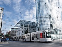
A Düsseldorf tram at Graf-Adolf-Platz [de].
Operation
LocaleDüsseldorf and Neuss, North Rhine-Westphalia, Germany
Horsecar era: 1876 (1876)–1900 (1900)
Status Converted to electricity
Track gauge 1,435 mm (4 ft 8+12 in)
Propulsion system(s) Horses
Electric tram era: since 1891 (1891)
Status Operational
Lines 7 (total line length 140.6 km (87.4 mi))
Operator(s) Rheinbahn
Track gauge 1,435 mm (4 ft 8+12 in)
Propulsion system(s) Electricity
Stock 175 [1]
Route length 78.0 km (48.5 mi)[1]
Stops 178 (2012)[1]
Düsseldorf tramway network.
Website Rheinbahn

The Düsseldorf tramway network (German: Straßenbahnnetz Düsseldorf) is a network of tramways serving Düsseldorf, the capital city of the federal state of North Rhine-Westphalia, Germany. In combination with the Düsseldorf Stadtbahn and Rhine-Ruhr S-Bahn, it forms the backbone of the public transport system in Düsseldorf.

The tramway network is currently operated by Rheinbahn AG, and is integrated in the Verkehrsverbund Rhein-Ruhr (VRR). As of 2016, its seven tram lines ran over 78.0 kilometres (48.5 mi) of route, serving 178 stops.[1]

History[edit]

Düsseldorf tram now in Summerlee, Museum of Scottish Industrial Life

In 1876, the first horse-drawn tram line opened in Düsseldorf operated by the Belgian entrepreneur Leopold Boyaert. It joined Castle Square with the Bergisch-Märkischen station and the concert hall.[2]

In 1896, the first electric tram ran in Düsseldorf,[2] and the full conversion of the system to electricity continued through 1900.[2]

Lines[edit]

As of 2016, seven tram lines[1] running on 78.0 kilometres (48.5 mi) of route,[1] operate in the city of Düsseldorf and in portions of the urban areas of Neuss:

Line Route Stops Run time Takt Mo.–Fr./Sa./Su.
701 Düsseldorf, Dome/Am Hülshof – ISS Dome – Wahlerstrasse/JVA – Düsseldorf-Rath S-Bahn Stadtbahn – Rotdornstraße StadtbahnDüsseldorf-Rath Mitte S-Bahn Stadtbahn – Am Schein Stadtbahn – Haeselerstraße Stadtbahn – Heinrichstraße Stadtbahn – Düsseldorf-Derendorf S-Bahn – Rather Straße /Hochschule HSD – Münsterplatz – Dreieck – Venloer Straße – Nordstraße Stadtbahn – Sternstraße – Schadowstraße (Downtown) StadtbahnSteinstraße (to Subway Königsalle) Stadtbahn – Berliner Allee – Luisenstraße – Helmholtzstraße – Sonnenstraße – Kruppstraße – Gangelplatz – Düsseldorf-Oberbilk S-Bahn Stadtbahn – Am Stufstock – Schlesische Straße Stadtbahn – Am Hackenbruch Stadtbahn – Jägerstraße StadtbahnDüsseldorf-Eller Mitte S-Bahn Stadtbahn – Alt Eller Stadtbahn – Vennhauser Allee (to Lore-Lorentz-Schule) Stadtbahn 31 35 min 10/10/15
(20/20/30)
704 Merziger Straße – Straßburger Straße – Alter Schlachthof – Rather Straße/Hochschule HSD – Sankt-Vinzenz-Krankenhaus – Lennéstraße – Stockkampstraße – Rochusmarkt – Adlerstraße – Pempelforter Straße Stadtbahn – Worringer Platz – Düsseldorf Hauptbahnhof S-Bahn Stadtbahn (Main Station) – Mintropplatz – Helmholtzstraße – Fürstenplatz – Morsestraße – Färberstraße – Karolingerplatz Stadtbahn – Auf’m Hennekamp Stadtbahn – Uni-Kliniken Stadtbahn – Universität Nord/Christophstraße Stadtbahn 19 29 min 10/15/15
(-/-/15)
705 Düsseldorf-Unterrath S-Bahn – Am Röttchen – Eckenerstraße – Elsässer Straße – An der Piwipp – Großmarkt – Johannstraße – Tannenstraße – Spichernplatz – Essener Straße – Dreieck – Venloer Straße – Nordstraße Stadtbahn – Marienhospital (only direction Unterrath) – Sternstraße – Schadowstraße (Downtown) Stadtbahn – Steinstraße (to Subway Königsallee) Stadtbahn – Berliner Allee – Luisenstraße – Corneliusstraße – Morsestraße – Färberstraße – Karolingerplatz Stadtbahn – Kopernikusstraße – Am Steinberg (only direction Merowingerplatz) – Merowingerstraße (only direction Merowingerplatz) – Moorenstraße (only direction Merowingerplatz) – Merowingerplatz 29 43 min 10/10/15
(20/20/30)
706 Düsseldorf-Hamm S-Bahn – Hammer Dorfstraße – Hemmersbachweg – Franziusstraße – Wupperstraße – Bilker Kirche – Stadttor – Landtag/Kniebrücke – Poststraße – Graf-Adolf-Platz Stadtbahn – Berliner Allee – Steinstraße (to Subway Königsallee) Stadtbahn – Schadowstraße (Downtown) Stadtbahn – Sternstraße – Marienhospital – Stockkampstraße – Tußmannstraße – Düsseldorf Zoo S-Bahn – Schillerplatz (only direction Am Steinberg) – Brehmplatz Stadtbahn – Schumannstraße – Lindemannstraße Stadtbahn – Lindenstraße – Düsseldorf-Flingern S-Bahn – Stadtwerke/Düsselstrand – Kettwiger Straße Stadtbahn – Fichtenstraße (to Subway Oberbilker Markt) Stadtbahn – Flügelstraße – Kruppstraße – Düsseldorf Volksgarten S-Bahn – Redinghovenstraße – Auf’m Hennekamp Stadtbahn – Kopernikusstraße – Am Steinberg (only direction Moorenstrasse) – Merowingerstraße (only direction Moorenstrasse) – Merowingerplatz (only direction Moorenstrasse) – Moorenstraße 35 51 min 10/15/15
707 Düsseldorf-Unterrath S-Bahn – Am Röttchen – Eckenerstraße – Elsässer Straße – An der Piwipp – Großmarkt – Johannstraße – Tannenstraße – Spichernplatz – Essener Straße – Dreieck – Venloer Straße (only direction Unterrath) – Marienhospital – Schloss Jägerhof – Jacobistraße – Klosterstraße – Charlottenstraße (only to Subway Oststraße) – Düsseldorf Hauptbahnhof (Main Station) S-Bahn Stadtbahn – Mintropplatz – Helmholtzstraße – Fürstenplatz – Morsestraße – Bilker Allee/Friedrichstraße – Kronprinzenstraße/Bilker Kirche – Wupperstraße – Franziusstraße – Speditionstraße – Medienhafen/Kesselstraße 29 43 min 10/10/15
708 Heinrichstraße Stadtbahn – Hansaplatz Stadtbahn – Grunerstraße Stadtbahn – Brehmplatz Stadtbahn – Schillerplatz Stadtbahn – Uhlandstraße Stadtbahn – Birkenstraße – Worringer Platz – Hauptbahnhof S-Bahn Stadtbahn – Stresemannplatz – Berliner Allee – Graf-Adolf-Platz Stadtbahn – Poststraße – Landtag/Kniebrücke – Polizeipräsidium 15 23 min 20/-/-
709 Gerresheim, Krankenhaus Stadtbahn – Heinrich-Könn-Straße Stadtbahn – Auf der Hardt/LVR-Klinikum Stadtbahn – Pöhlenweg Stadtbahn – (Grafenberg, Staufenplatz) – Burgmüllerstraße Stadtbahn – Schlüterstraße/Arbeitsagentur Stadtbahn – Engerstraße – Hoffeldstraße – Düsseldorf-Flingern S-Bahn – Wetterstraße – Birkenstraße – Worringer Platz – Düsseldorf Hauptbahnhof (Main Station) S-Bahn Stadtbahn – Stresemannplatz – Berliner Allee – Graf-Adolf-Platz Stadtbahn – Poststraße – Landtag/Kniebrücke – Stadttor – Bilker Kirche – D-Völklinger Straße S-Bahn – Georg-Schulhoff-Platz – Südfriedhof – Josef-Kardinal-Frings-Brücke – Neuss-Rheinpark Center Süd – Langemarckstraße – Neuss Stadthalle/Museum – Landestheater – Neuss Markt – Glockhammer – Niedertor – Neuss Hauptbahnhof (Main Station) S-Bahn Stadtbahn – Neuss-Theodor-Heuss-Platz 33 54 min 10/10/15
(20/20/30)

After finishing work at the Wehrhahlinie, many of the tram lines (703, 712, 713 and 715) have been moved to the new Stadtbahn service.

Rolling stock[edit]

The current tram fleet consists of low-floor trams which are good for wheelchair accessibility.

See also[edit]

References[edit]

Notes[edit]

  1. ^ a b c d e f "Zahlenübersicht Stand 31. Dezember 2012" [Figures Summary as of December 31, 2012] (PDF) (in German). Rheinbahn. December 31, 2012. p. 7. Retrieved 2013-10-19.
  2. ^ a b c "1920: Das Ende der Düsseldorfer Straßenbahn" [1920: The end of the Düsseldorf tram [company]] (in German). Rheinbahn. Retrieved 2013-10-19.

Bibliography[edit]

  • Höltge, Dieter (1994). Straßen- und Stadtbahnen in Deutschland [Tramways and Stadtbahnen in Germany] (in German). Vol. Band 4: Ruhrgebiet - Von Dortmund bis Duisburg [Volume 4: Ruhr - from Dortmund to Duisburg]. Freiburg i. B., Germany: EK-Verlag. ISBN 9783882553345.
  • Nolden, Hans G (1998). Die Düsseldorfer Straßenbahn [The Düsseldorf Tramway] (in German). München: GeraMond Verlag. ISBN 3932785029.
  • Schwandl, Robert (2012). Schwandl's Tram Atlas Deutschland (in German and English) (3rd ed.). Berlin: Robert Schwandl Verlag. pp. 46–48. ISBN 9783936573336.

External links[edit]

51°14′N 06°47′E / 51.233°N 6.783°E / 51.233; 6.783