Tapoa Province
Tapoa | |
|---|---|
Province | |
 Location in Burkina Faso | |
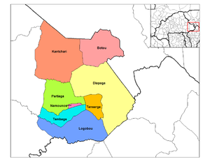
 Provincial map of its departments | |
| Country | |
| Region | Est Region |
| Capital | Diapaga |
| Area | |
| • Province | 5,626 sq mi (14,572 km2) |
| Population (2019 census)[1] | |
| • Province | 605,110 |
| • Density | 110/sq mi (42/km2) |
| • Urban | 15,515 |
| Time zone | UTC+0 (GMT 0) |
Tapoa is one of the 45 provinces of Burkina Faso. It is located in the Est Region. Its capital is Diapaga.
Departments[edit]
Tapoa is divided into 8 departments:
| Departments | Capitals | Population (Census 2006)[2] |
|---|---|---|
| Botou Department | Botou | 46,898 |
| Diapaga Department | Diapaga | 32,260 |
| Kantchari Department | Kantchari | 59,150 |
| Logobou Department | Logobou | 61,422 |
| Namounou Department | Namounou | 15,077 |
| Partiaga Department | Partiaga | 50,303 |
| Tambaga Department | Tambaga | 41,137 |
| Tansarga Department | Tansarga | 35,535 |
See also[edit]
References[edit]
- ^ Citypopulation.de Population of provinces in Est Region
- ^ National 2006 census preliminary results
12°05′N 1°48′E / 12.083°N 1.800°E
