
Talk:Shephelah
| This is the talk page for discussing improvements to the Shephelah article. This is not a forum for general discussion of the article's subject. |
Article policies
|
| Find sources: Google (books · news · scholar · free images · WP refs) · FENS · JSTOR · TWL |


|
This article links to one or more target anchors that no longer exist.
Please help fix the broken anchors. You can remove this template after fixing the problems. | Reporting errors |
removed copyright violation[edit]
I've [removed several paragraphs http://en.wikipedia.org/w/index.php?title=Shephelah&diff=52704429&oldid=32507936]. The Wikimedia Foundation information team was notified that they are a copyright violation. (Ref: OTRS 2006051110001271). If anyone wants to replace this information in their own words they are welcome to do so, but copying text directly from other sources is generally unacceptable. FreplySpang (talk) 19:05, 11 May 2006 (UTC)
Bible[edit]
Is a listing of every single mention in the Bible really appropriate to the introduction? It may well make sense to have a section on references in the Bible somewhere in the article, hopefully giving a little more information than merely a list of the books, chapters and verses, but the introduction is not the place for it. Skinsmoke (talk) 06:24, 21 February 2011 (UTC)
- Problem solved.Alephb (talk) 17:50, 27 January 2017 (UTC)
- The term does come from the Bible, or is there any equivalent Arabic term too? Therefore, and because the boundaries are not clear at all: please put those quotations back in, in a paragraph of its own ("In the Hebrew Bible" or alike), so we can see at least from the context what is meant. Thanks, Arminden (talk) 11:31, 5 January 2021 (UTC)
Boundaries very vague, need elaborating[edit]
See discussion above: apart from the Bible, is there any equivalent Arabic term too that can help with defining the boundaries? Can anyone find & translate a definition from an Israeli geography book? Bolter21 did an excellent such job at Talk:Mount Hebron#We don't have a definition yet. What are the geographical boundaries?. It should be coordinated with the similar effort for the regions Judaean mountains (with 3 segments, that is, I presume, the Jerusalem-Ramallah section sometimes called Bet-El mountains -if they do reach all the way down west, to the Shephelah-, the Jerusalem mountains, and Mount Hebron), Israeli coastal plain, and we would need an article on the Beersheba Valley/Beersheba-Arad Valley, i.e. the Negev of the Bible. We need a northern limit too. Arminden (talk) 21:52, 5 January 2021 (UTC)
- In general, the Shefela is the transitional region between the Judean hills and the coastal plain. It is clearly a different rock formation than the central hill region, as you can see in this map. Here you can see how the Israeli Society for the Protection of Nature defines it (it includes both the highlighted region in blue and the gree region below it - north and south respectively).
- This is what the 2001 New Israel Guide's volume on the Shfela says:
- השפלה היא יחידת הנוף המערבית של ארץ יהודה , המשתפלת למרגלותיה , ומכאן גם שמה . השפלה היא חבל ביניים בין הרי יהודה ממזרח לבין מישור החופ ממערב . קביעת גבולות השפלה כרוכה בקשיים מסוימים , שכן בצפונה נמצאת יחידת נוף הדומה לה במבנה הטופוגרפי וברום - הדום הרי שומרון . אולם יחידת נוף זו שונה מהשפלה בזמן היווצרותה , במסלע שלה ובתהליכים הגיאולוגיים שעיצבו אותה . גבולה הצפוני של השפלה נקבע אפוא על פי תפוצת הסלעים האופייניים לה . גבול זה עובר באזור מעבר אפק , ששם אפיקו של נחל שילה ( ואדי א - נאטוף ) הוא הגבול בין תפוצת סלעי הגיר הקשים והדולומיט של הדום הרי שומרון מצפון לבין סלעי הקרטון מכוסי הנרי של השפלה מדרום . גבולה הדרומי של השפלה נקבע , הן מטעמים היסטוריים הן מבחינת הנוף , באפיקו של נחל שקמה . אך גם כאן קשה להגדיר גבול זה במדויק , שכן יש מעבר הדרגתי מן המבנה הגבעי של השפלה אל מישורי בקעת באר שבע וצפון הנגב . מכיוון שבשפלה מצויות כבר הרבדות של לס מן הנגב , קשה לציין את קו המעבר המוחלט מן השפלה אל דרום הארץ . גבולה המערבי של השפלה אף הוא אינו חד , אלא הדרגתי , בשל צביונה של השפלה כמדרגת מעבר נופית . לכאורה היה צריך לקבוע את הגבול במקום שבו מסתיימות גבעות השפלה ומתחילות אדמות הסחף של מישור החופ , אך התרחבות עמקי הנחלים במערב השפלה גורמת לחדירה עמוקה יחסית של אדמות סחף אלה אל תחום השפלה ולטשטוש קו הגבול . יתר על כן , גבעות השפלה מתנמכות בהדרגה , ולעתים הן נראות כגבנונים בודדים בתחום מישור החופ . גבולה המזרחי של השפלה ברור וחד ; הוא נקבע למרגלות הכפיפה המערבית העזה של האנטיקלינה של הרי יהודה . כפיפה זו גרמה להפרש גבהים ניכר בין ההר לבין מדרגת השפלה - מ - 900 מ' בהר חברון ל - 450 מ' באזור בית גברין , ומ - 800 מ' בהר בית אל לך - 250 מ' באזור לטרון - ולהיווצרות מערכת של עמקי אורך צרים , אבוסים או עמקי תלם , בין השפלה להר . גבול זה חופף גם את המעבר מתפוצת סלעי הקרטון של השפלה אל סלעי הגיר הקשים והדולומיטים של הרי יהודה .
- The Shfela is the western geographic unit of the Land of Judea, which slopes to its foot, giving it its name. The Shfela is an intermediate strip of land between the Judean mountains to the east and the coastal plain to the west. Determining the borders of the Shfela is difficult, as in its north there is another geographic body similar in shape and height - the Samarian footstool. This geographic unit is different than the Shfela in its formation time, in its rock type, and in the geologic process that formed it. The southern border of the Shfela is determined due to historic reasons and by the landscape in the Shikma Stream. But here as well it is difficult to establish a border precisely, as there is a gradual transition from the hilly structure of the Shfela to the plains of the Beersheba valley and the northern Negev. Since loess sediments from the Negev are found in the Shfela it is difficult to demarcate the exact transition line from the Shfela to the South. The western border of the Shfela isn't sharp but gradual due to the transitional landscape of the Shfela. Seemingly the western border of the Shfela is in the location where the hills end and the alluvial lands of the coastal plain begin, but the extension of the river valleys in the western Shefela causes deep penetration of these alluvial lands to the boundary of the Shfela and the blurring of the borderline. Furthermore, the Shfela hills are lowered gradually and are often seen as single hills in the boundary of the coastal plain. The eastern border of the Shfela is clear and sharp; it is defined in the foot of the flexion of the Judean Mountains' anticline. This flexion creates a clear height difference between the mountain and the Shfela - from - 900 m. in Mount Hebron to - 450 m. in the area of Beit Guvrin, and from - 800 m. in Mount Beit El to - 250 m. in the area of Latrun - and to the creation of a network of narrow, wide or furrow valleys between the Shfela and the mountain. This border overlaps the transition from the chalk formation of the Sfhela to the harsh limestone formation and the dolomites of the Judean mountains.
- Apologies for the clunky translation--Bolter21 (talk to me) 20:44, 13 January 2021 (UTC)
- Late reply to Bolter21: thank you, that offers a lot to those who know the country by heart, both in terms of geomorphology and geology, and not so much to those who don't :)
- "Stealing" a pre-existing map has always been the only solution for enWiki in such situations. A topographical map with settlements and roads marked on it would speak by itself. Arminden (talk) 18:00, 23 March 2024 (UTC)
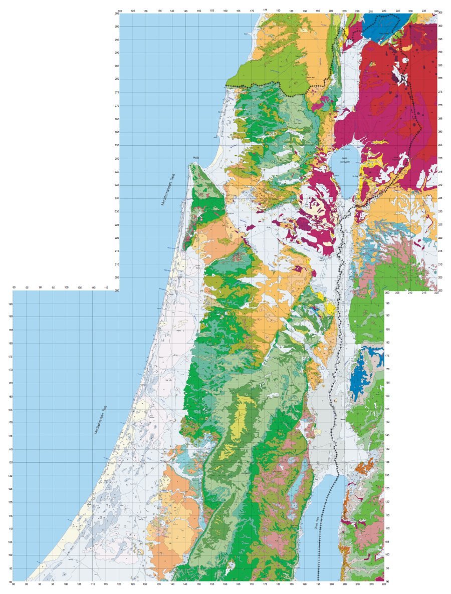
Map at "Geography": wrong, misleading[edit]
Whoever did the effort with the first map took a great stride forward: we now have the contours. The points of reference are still missing, orientation almost impossible, but still.
The map at the "Geography" section however is completely wrong: instead of an irregular elongated N-S shape halfway between hill country and Med, it shows a red square ??!! going all the way into the sea by quite a bit. Underwater Shephelah - "Dan, why did he stay with his submarines?" (Judges 5:17, NWV - New Wiki Version). The Hebrew writing doesn't help much either, and beyond being illegible to the user it even misleads into thinking those towns were part of the discussed region; they're not. Arminden (talk) 17:50, 23 March 2024 (UTC)
- And so you get to Talk:Sitria#In the Shfela, really?. Arminden (talk) 18:13, 23 March 2024 (UTC)
- The second map has a small-scale section (at left) and a large-scale one (at right). The red-bordered rectangle on the small-scale part just shows where the borders of the large-scale map are located, as is usually the convention with similar maps at different scales. The large-scale map shows, as its legend says, cities surrounding the Shfela, not necessarily in it. Nothing wrong AFAICT, and I personally don't feel misled. I would have preferred city names in Latin script though, for an English Wikipedia where the majority script is Latin, but this preference of mine doesn't make the map "wrong" per se, all the less so since square-script names are transliterated in the legend. — Tonymec (talk) 19:38, 4 April 2024 (UTC)
- C-Class Bible articles
- Mid-importance Bible articles
- WikiProject Bible articles
- C-Class Judaism articles
- Mid-importance Judaism articles
- C-Class Israel-related articles
- Mid-importance Israel-related articles
- WikiProject Israel articles
- C-Class geography articles
- Mid-importance geography articles
- WikiProject Geography articles