
Talk:Latrun salient
| This article has not yet been rated on Wikipedia's content assessment scale. It is of interest to the following WikiProjects: | |||||||||||
| |||||||||||

Copy from Dan Palraz talk page section[edit]
Lapid and Shilat
These villages are not in the West Bank; Shilat is half inside the green line and half in the Latrun salient (no-man's land). Lapid is fully in the salient, but again this is not the West Bank. Please undo your edits. Thanks, Number 57 17:37, 13 December 2022 (UTC)
- It isn't me or you who say what is a settlement and what isn't; they are built over area which was out of Israel control before 1967 and are therefore settlements in international law: https://www.ochaopt.org/atlas2019/images/db/israeli-settlements-checkpoints/israeli-settlments.pdf Dan Palraz (talk) 22:02, 13 December 2022 (UTC)
- Can't you read? https://www.ochaopt.org/atlas2019/images/db/israeli-settlements-checkpoints/israeli-settlments.pdf Dan Palraz (talk) 22:26, 13 December 2022 (UTC)
- I can read a map, which makes it clear that source is wrong. Sources are not always correct. Number 57 22:29, 13 December 2022 (UTC)
- The official United Nations body that defines what is an Israeli settlement in the West Bank says it is an Israeli settlement in the West Bank. By the way, I also don't know what you mean by "reading a map", but the image in the article itself clearly puts Kfar Ruth inside the yellow area (the West Bank). But again, I have provided official source saying Kfar Ruth is an Israeli settlement; if you find a source saying Kfar Ruth is not a settlement, be my guest. Dan Palraz (talk) 22:31, 13 December 2022 (UTC)
- I can read a map, which makes it clear that source is wrong. Sources are not always correct. Number 57 22:29, 13 December 2022 (UTC)
- Can't you read? https://www.ochaopt.org/atlas2019/images/db/israeli-settlements-checkpoints/israeli-settlments.pdf Dan Palraz (talk) 22:26, 13 December 2022 (UTC)
- Anyone with a basic understanding of geography can read a map like this and see that the villages are located between the armistice lines (in no-man's land), and therefore not in the West Bank. Shilat is half in Israel and half in no-man's land, so labelling it as "in the West Bank" is even more ridiculous than doing it for the other two. Number 57 22:39, 13 December 2022 (UTC)
- This is not how Wikipedia works. The officials on what is an Israeli settlement says they are Israeli settlements; if you are so sure they are wrong, you can publish an article on it and then you can someone can use it as a source on Wikipedia to un-do the changes... Dan Palraz (talk) 22:41, 13 December 2022 (UTC)
- Anyone with a basic understanding of geography can read a map like this and see that the villages are located between the armistice lines (in no-man's land), and therefore not in the West Bank. Shilat is half in Israel and half in no-man's land, so labelling it as "in the West Bank" is even more ridiculous than doing it for the other two. Number 57 22:39, 13 December 2022 (UTC)
Anyway, as you yourself say, if you want to change long-established wording, take it to the talk page, rather than force changes in by reverting. Number 57 22:41, 13 December 2022 (UTC)
- The difference is that your "position" doesn't have nor has ever had any source, other than the fact that you claim to know it, which isn't really how Wikipedia works. Good luck with changing the international definition of settlements. Dan Palraz (talk) 22:43, 13 December 2022 (UTC)
- It is how Wikipedia works though. Editors critically assess sources and can discard them if they can clearly shown to be wrong, which is the case here. Number 57 22:48, 13 December 2022 (UTC)
- Where have you shown it as wrong, I must have missed that? I can't see Lapid on the list at a glance but the other two are there. Selfstudier (talk) 22:52, 13 December 2022 (UTC)
- It is how Wikipedia works though. Editors critically assess sources and can discard them if they can clearly shown to be wrong, which is the case here. Number 57 22:48, 13 December 2022 (UTC)
- Um, if there is a RS saying a thing and you want to dispute that, you need a reliable source to back that up (we don't need to read any maps because the source will say what it is or what it is not). Selfstudier (talk) 22:43, 13 December 2022 (UTC)
- This also
Selfstudier (talk) 23:20, 13 December 2022 (UTC)But it turns out that, like Neve Shalom, the state never officially annexed Maccabim and other nearby communities: Kfar Ruth, Lapid and Shilat. “The EU is right that it’s not part of Israel, because we didn’t issue a Foreign Office Certificate for them,” notes Robbie Sabel, the ministry’s former legal adviser, adding, “The EU did not assert that it was Jordanian territory, but did state that it didn’t belong to Israel before 1967.”
Number 57 is right on this, and I think Zero0000 would be able to verify that as well. You can say a portion of Shilat is outside of Israel's sovereign territory, while a portion of it is inside that territory, but that portion is also is not in the West Bank, which does not include no man's land. Israel occupied that territory, but it isnt either part of the West Bank or in the Palestinian territories or state of Palestine, whatever wording youd prefer to use. nableezy - 23:48, 13 December 2022 (UTC)
I don't think "West Bank" is a precisely defined term when it comes to the demilitarised zones. Israel considers the Latrun Salient to be in Israel (despite no formal annexation) but I'm not surprised if the UN or someone else calls it West Bank. Number 57's description of the locations is correct, though. I think the best thing would be to use Latrun Salient in the location descriptions. I'm in favor of territorial disputes being treated centrally rather than all over the place. On the other hand, reliable sources call them settlements and I don't see a problem with following suit. Zerotalk 04:01, 14 December 2022 (UTC)
- @Nableezy and Zero0000: Unfortunately Dan has again reverted, changing the introductions of the respective articles as follows:
- Kfar Ruth from "Kfar Ruth is an Israeli moshav located near Modi'in in the Latrun salient of the Green Line." to "Kfar Ruth is an Israeli settlement in the West Bank"
- Shilat from "Shilat is a moshav partially in Israel and partially in the Latrun salient of the Green Line." to "Shilat is an Israeli settlement in the West Bank"
- If you would be able to restore the correctly-worded versions of these articles, it would be appreciated. The changes to Shilat are particularly ridiculous, but it seems he has ignored the comments above. Cheers, Number 57 22:47, 16 December 2022 (UTC)
- @Nableezy and Zero0000: Unfortunately Dan has again reverted, changing the introductions of the respective articles as follows:
- During peace talks, Israel does not include the annexed areas in East Jerusalem, the no-man's land and the Palestinian part of the Dead Sea for the purposes of calculating the percentage of the West Bank that Palestine would get, about a 5% difference, see 2000 Camp David Summit. It seems clear from the Haaretz source that while technically, they are not Israeli territory, the area will likely get rolled up in so called "swaps" ( treated as settlements in the WB that Israel wants to keep in exchange for territory elsewhere.) Selfstudier (talk) 09:55, 14 December 2022 (UTC)
- We could perhaps use wording along the lines of that used in Modi'in-Maccabim-Re'ut "....(the Maccabim neighborhood) is not recognized by the European Union as being in Israel, as it lies in what the 1949 Armistice Agreement with Jordan left as a no man's land, and was occupied in 1967 by Israel after it was captured from Jordan together with the West Bank proper.[1][2]
Selfstudier (talk) 10:16, 14 December 2022 (UTC)
- I don't think it is only the EU. There are also two related problems at Lapid, Israel: (1) The title says it is in Israel, which is POV. The title arose from an RM on the talk page in which nobody mentioned the problem with the location. (2) "Before the Six-Day War in 1967, this territory did not belong to either Jordan or Israel" implies that it now does belong to someone, also POV. Zerotalk 01:18, 17 December 2022 (UTC)
- Given the ambiguities, in rsality and in sources, perhaps we should all strive to get some consensual arrangement here on how to deal with these several places in a consistent way, as was done when Avi had expressed some perplexity over the status of Canada Park.Nishidani (talk) 08:59, 17 December 2022 (UTC)
- This goes back to Res 242, it may not be in the WB but it is not in Israel either, Res 242 refers to the "territories occupied" and that includes the Salient. Subsequently, the ICJ ruled that the business about the sovereign was irrelevant and that Jordan was to be treated as HCP for the purpose of defining the occupied territory. Per Zero, we probably need a separate article on that bit of territory to clarify matters. However one thing is clear, while it is true that Dan's move was undiscussed, it is more POV to revert that move than it would have been to have left it be, and started a discussion from there.
- According to Btselem, the Latrun salient is not considered occupied territory under international law.
- This is the problem; the articles did not state they were in Israel, they stated they were in the Latrun salient. Dan keeps reverting to his (incorrect) version stating they are in the West Bank (which is clearly nonsense with regards to Shalit). Lapid could just be moved to Lapid (community settlement), which takes away any locational element. Number 57 15:21, 17 December 2022 (UTC)
- Or Lapid (Israeli settlement), which would surely be many birds with one stone - descriptive and precise, but not geographically deterministic. Iskandar323 (talk) 16:11, 17 December 2022 (UTC)
- No, because it's not an Israeli settlement in the usual sense (i.e. it is not in occupied territory). Number 57 16:49, 17 December 2022 (UTC)
- That B'tslem doc (a draft) is wrong, it says "Israel also annexed to its territory a strip of land parallel to the Green Line along a few kilometers north and south of the Latrun area.." when we already know for a fact that Israel did not annex the territory and if they had it would be just as illegal as the other annexations anyway (ie it is occupied territory). We can address all these points in a proper article. Personally I am not bothered whether it says "Israeli settlement" and what Dan had was fine.
- The B'tselem text in fuill reads,
In addition, Israel also annexed to its territory a strip of land parallel to the Green Line along a few kilometers north and south of the Latrun area (see the map attached to this report). This strip of land had been known as “no man’s land,” because in 1948-1967 it was not subject to the control of either the Israeli or the Jordanian side. Over the years, Israel established three communities in this area (Shilat, Kfar Ruth and Maccabim). We shall not relate to these settlements in this report, since under international law this area is not considered occupied territory.
- That definitely supports Number57s pointof view.
- Since that is a draft, one could question its RS status of course. But B'tselem even in drafting would not make such a statement were it not grounded in strong evidence. In any case it is the kind of statement that should be ytraceable back to the appropriate source, some authority on international law. If technically, the land is not Occupied, it is equally true that Israel's annexation of the Salient is not recognized. Obviously, we require an article on the Latrun salient to cover all of the relevant legal, historical issues to allow readers, not to speak of ourselves, clarity in this confusion.Nishidani (talk) 17:48, 17 December 2022 (UTC)
- There is a final version of that Land Grab doc, idk why the draft is posted. As counterpoint, we have Latrun No Man’s Land (1949-1967) "Most of the international community views the area as occupied Palestinian territory, along with the adjacent West Bank." Selfstudier (talk) 18:45, 17 December 2022 (UTC)
- University of Bologna Law Review ISSN 2531-6133 VOL.4:1 2019
- "Accordingly, the West Bank of the Jordan River (including East Jerusalem as well as the narrow strips of territories known as the “no man’s land” in the Latrun and Jerusalem regions) were among the territories which fell under the occupation of Israel." Selfstudier (talk) 19:00, 17 December 2022 (UTC)
- Both Dan and Number err, in my view, by taking diametrically opposed viewpoints that ignore the technical complexities. Dan because his premise appears to be that West-Bank is anything east not-Israel down to 1967. Number because, even if in international law, the Latrun salient was not 'occupied', that does not mean that Israeli settlements there form part of Israel. They are places which in international law are still in no man's land, 'annexed' or not. So, stating that Lapid or the others are in Israel, as the versions Number supported state, Israel is a violation of NPOV. Nishidani (talk) 20:00, 17 December 2022 (UTC)
- I have not stated they are in Israel (except Shilat, which partially is) – see the text of the articles (which Dan keeps changing) above (i.e. "Kfar Ruth is an Israeli moshav located near Modi'in in the Latrun salient of the Green Line.", "Shilat is a moshav partially in Israel and partially in the Latrun salient of the Green Line.". Lapid's intro is: "Lapid is an Israeli community settlement. Located in the Latrun Salient of the Green Line near Modi'in Illit..."). The issue here is that edits keep being forced back into the articles claiming these are in the West Bank. Number 57 20:41, 17 December 2022 (UTC)
- Well not to state is one thing, but in your edits you seem to be insisting on a default description of those places as in 'central Israel,' e.g. here. You had a case against Dan's claim, but, as far as I can see, you called on him to revert to a version that was equally flawed, one you hadn't corrected. That led to my inference. Nishidani (talk) 21:10, 17 December 2022 (UTC)
- I hadn't realised the short decription described it as being in Israel (it doesn't appear in the text). I obviously have no issue with that being corrected. Number 57 22:38, 17 December 2022 (UTC)
- Fair enough. I also never note such minutiae. The problem only emerges if one checks the diff flow. Sorry for the inference that you endorsed it. By the same token, it is the sort of thing that might have triggered Dan's response. Well, that at least is settled. Cheers Nishidani (talk) 22:43, 17 December 2022 (UTC)
- I hadn't realised the short decription described it as being in Israel (it doesn't appear in the text). I obviously have no issue with that being corrected. Number 57 22:38, 17 December 2022 (UTC)
- Well not to state is one thing, but in your edits you seem to be insisting on a default description of those places as in 'central Israel,' e.g. here. You had a case against Dan's claim, but, as far as I can see, you called on him to revert to a version that was equally flawed, one you hadn't corrected. That led to my inference. Nishidani (talk) 21:10, 17 December 2022 (UTC)
- I have not stated they are in Israel (except Shilat, which partially is) – see the text of the articles (which Dan keeps changing) above (i.e. "Kfar Ruth is an Israeli moshav located near Modi'in in the Latrun salient of the Green Line.", "Shilat is a moshav partially in Israel and partially in the Latrun salient of the Green Line.". Lapid's intro is: "Lapid is an Israeli community settlement. Located in the Latrun Salient of the Green Line near Modi'in Illit..."). The issue here is that edits keep being forced back into the articles claiming these are in the West Bank. Number 57 20:41, 17 December 2022 (UTC)
- Both Dan and Number err, in my view, by taking diametrically opposed viewpoints that ignore the technical complexities. Dan because his premise appears to be that West-Bank is anything east not-Israel down to 1967. Number because, even if in international law, the Latrun salient was not 'occupied', that does not mean that Israeli settlements there form part of Israel. They are places which in international law are still in no man's land, 'annexed' or not. So, stating that Lapid or the others are in Israel, as the versions Number supported state, Israel is a violation of NPOV. Nishidani (talk) 20:00, 17 December 2022 (UTC)
- That B'tslem doc (a draft) is wrong, it says "Israel also annexed to its territory a strip of land parallel to the Green Line along a few kilometers north and south of the Latrun area.." when we already know for a fact that Israel did not annex the territory and if they had it would be just as illegal as the other annexations anyway (ie it is occupied territory). We can address all these points in a proper article. Personally I am not bothered whether it says "Israeli settlement" and what Dan had was fine.
- No, because it's not an Israeli settlement in the usual sense (i.e. it is not in occupied territory). Number 57 16:49, 17 December 2022 (UTC)
- I don't think it is only the EU. There are also two related problems at Lapid, Israel: (1) The title says it is in Israel, which is POV. The title arose from an RM on the talk page in which nobody mentioned the problem with the location. (2) "Before the Six-Day War in 1967, this territory did not belong to either Jordan or Israel" implies that it now does belong to someone, also POV. Zerotalk 01:18, 17 December 2022 (UTC)
The most detailed description I know is by the Israeli geographer Gideon Biger, Latrun — A no man's land in Israel, European Journal of Geopolitics, vol 4, 2016, 122–131. Biger confirms that it was never officially annexed by Israel, so Btselem's 2002 article is wrong on that point. Zerotalk 00:39, 18 December 2022 (UTC)
- It's an interesting topic; Based on this summary of negotiations between the parties, it seems the Israeli view is that since it was no-man's land, they didn't need to officially annex it (Before the Six Day War, part of the area was a no man’s land. Accordingly, the Israelis relate to the area as an integral part of Israel). Raja Shehadeh states that the land was "outright annexed without using the term". The fact that the three villages in question are under the jurisdiction of Hevel Modi'in Regional Council (i.e. within the municipal boundaries of Central District) would suggest that the area has effectively been annexed. Kfar HaOranim, which is contiguous with Lapid, but in the West Bank, is deemed under the jurisdiction of Mateh Binyamin Regional Council and therefore in Judea and Samaria Area. Number 57 01:47, 18 December 2022 (UTC)
- That font of neutrality, the CIA factbook description of WB says "note: includes West Bank, Latrun Salient, and the northwest quarter of the Dead Sea, but excludes Mt. Scopus; East Jerusalem and Jerusalem No Man's Land are also included only as a means of depicting the entire area occupied by Israel in 1967". There is in all likelihood a de facto annex by Israel but since all sources agree that the area was occupied by Israel post 67 (whether or not you refer to it as WB), then any such annex is illegal. Selfstudier (talk) 10:24, 18 December 2022 (UTC)
- Okay chaps/chapesses. At this point several good sources have been provided and rather than continue cluttering the talk page with them, I think it is time to roll up the sleeves and write up a stub where these can be used productively. I'll sketch out a Latrun salient, using Biger's outline, afteer lunch, say in an hour or two, depending on the digestability of my brother-in-law's pasta.Nishidani (talk) 12:08, 18 December 2022 (UTC)
- I was actually just in the process of doing this at Latrun salient. I have also moved Lapid to Lapid (community settlement). Unfortunately Selfstudier has blindly reverted an attempt to correct the Kfar Ruth article (not realising that the article does not claim the village is in in Israel)... Number 57 12:39, 18 December 2022 (UTC)
- I know exactly what I am doing, thanks. There is an ongoing discussion and we should take it to Latrun salient article and finish it rather than trying to push our own preferred version. So I copied this section to there and we should continue there rather than cluttering Dan's page any further. Selfstudier (talk) 13:04, 18 December 2022 (UTC)
- We have a clear consensus above that the villages are correctly described as being "in the Latrun salient" rather than in Israel or in the West Bank. This kind of bullshit (constant pointy reverts) is exactly why I rarely bother to try and edit articles in this topic sphere anymore, despite being interested and (I think) having something to contribute. Number 57 13:16, 18 December 2022 (UTC)
- Reverting Dan's move was pointy (as well as wrong). And you have now moved it to community settlement without agreement on top of that. So pot kettle etc. Selfstudier (talk) 13:26, 18 December 2022 (UTC)
- Now as to this "clear consensus", we have reliable sources referring to these places as Israeli settlements and conflicting sources as to whether they are considered as being in the WB. So lets start writing up this article and see where we get to. Selfstudier (talk) 13:32, 18 December 2022 (UTC)
- We have a clear consensus above that the villages are correctly described as being "in the Latrun salient" rather than in Israel or in the West Bank. This kind of bullshit (constant pointy reverts) is exactly why I rarely bother to try and edit articles in this topic sphere anymore, despite being interested and (I think) having something to contribute. Number 57 13:16, 18 December 2022 (UTC)
- I know exactly what I am doing, thanks. There is an ongoing discussion and we should take it to Latrun salient article and finish it rather than trying to push our own preferred version. So I copied this section to there and we should continue there rather than cluttering Dan's page any further. Selfstudier (talk) 13:04, 18 December 2022 (UTC)
- I was actually just in the process of doing this at Latrun salient. I have also moved Lapid to Lapid (community settlement). Unfortunately Selfstudier has blindly reverted an attempt to correct the Kfar Ruth article (not realising that the article does not claim the village is in in Israel)... Number 57 12:39, 18 December 2022 (UTC)
- Okay chaps/chapesses. At this point several good sources have been provided and rather than continue cluttering the talk page with them, I think it is time to roll up the sleeves and write up a stub where these can be used productively. I'll sketch out a Latrun salient, using Biger's outline, afteer lunch, say in an hour or two, depending on the digestability of my brother-in-law's pasta.Nishidani (talk) 12:08, 18 December 2022 (UTC)
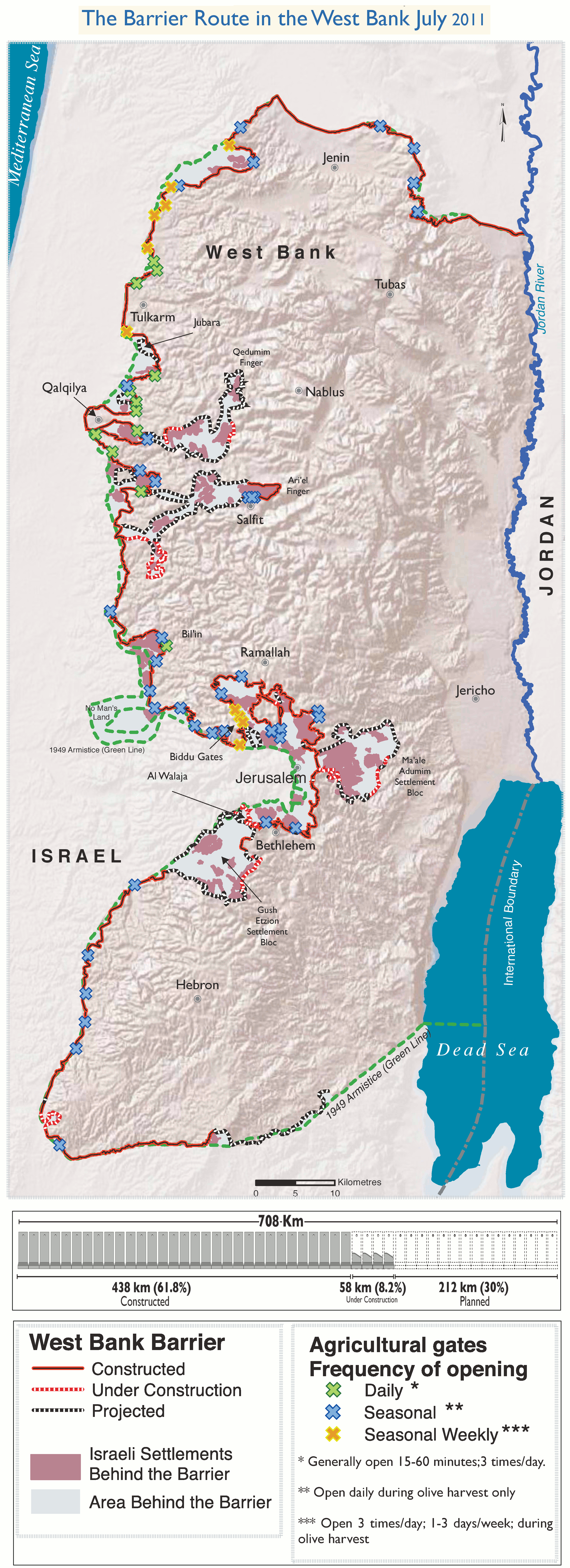
West Bank barrier[edit]
this pic shows the barrier route cutting off the salient (behind Mevo Horon, I think). Anyone know of a better pic? Selfstudier (talk) 17:56, 18 December 2022 (UTC)
Salient versus no man's land[edit]
I'm getting confused. The "salient" is a "finger" of the West Bank which has been cut off by the wall behind Mevo Horon an Israeli settlement in the salient.
Around the finger is a strip which is the no man's land and contains 5 Israeli settlements.
If that's right, then the first line of the lead is not correct? Selfstudier (talk) 19:57, 18 December 2022 (UTC)
- The line is what Biger states, defining the area in terms of the 1949 armistice. We need as a priority a map of that territory as marked in 1949 then (2) a map of the alterations within that territory made by Israel following 1967. Thew two should not be confused.Nishidani (talk) 20:30, 18 December 2022 (UTC)
- In the meantime, the whole sorry mess is described in detail here. Al Haq is activist NGO but the article seems well written and sourced and I have no reason to doubt the content at this point. Some maps, too. It seems that as well as appropriating the actual no man's land, there is as well a defacto annex of WB territory (the part where the Palestinian villages were razed and the residents forcibly expelled).Selfstudier (talk) 23:10, 18 December 2022 (UTC)
- Yes, that is an excellent source by the looks of it. I will read it tomorrow. There's nothing to object to. Despite the punkish smearing of the group recently, it is a respectable human rights organization with an excellent record of fine research. One thing editors might try to get RS on is the two day tractor war of late October 1965 (a repeat of the tactic used on the no man's land between the Golan and Israel in the 1950s, whose successful provocations Moshe Dayan boasted about two decades later, the dunam-by-dunam approach to sidestepping the usual conflict resolution processes to create facts on the ground on the old principle that possession is 9/10s of the law. Nishidani (talk) 23:40, 18 December 2022 (UTC)
- For example, Jordan would probably trade the Latrun salient, a narrow finger of the West Bank that used to cut the main Tel Aviv-Jerusalem road, WAPO, back in 78. Selfstudier (talk) 23:21, 18 December 2022 (UTC)
- In the meantime, the whole sorry mess is described in detail here. Al Haq is activist NGO but the article seems well written and sourced and I have no reason to doubt the content at this point. Some maps, too. It seems that as well as appropriating the actual no man's land, there is as well a defacto annex of WB territory (the part where the Palestinian villages were razed and the residents forcibly expelled).Selfstudier (talk) 23:10, 18 December 2022 (UTC)
- [1] is the armistice lines, you can see the finger with Imwas and Oyal in the middle, surrounded by the armistice lines.Selfstudier (talk) 23:31, 18 December 2022 (UTC)
![[1]](https://www.un.org/unispal/wp-content/uploads/1949/04/f03d55e48f77ab698525643b00608d34_Arm_1949.jpg)
- Jerusalem Quarterly Issue 81] pages 113/4,~referencing the same map, "...The route of the Jaffa-Jerusalem road was shifted north inside the no man’s land. Recent map versions show hidden lines indicating the underground route of the recently established high speed train between Tel Aviv and Jerusalem. The "cartographic blob" of Latrun area that resulted from the 1949 Armistice line had already been swallowed..." Selfstudier (talk) 23:38, 18 December 2022 (UTC)
- This book refers to a dispute over the exact position of the opposing forces on the date the armistice was signed.Selfstudier (talk) 11:21, 19 December 2022 (UTC)
- Sources use variously Latrun Salient, Latrun area, no man's land as if all three terms imbricated one over another. The problem lies in determining the3 distinctions if any, perhaps by using 1949 as a starting point.Nishidani (talk) 11:56, 19 December 2022 (UTC)
- This says "The Latrun enclave was occupied in the 1967 war; the three Palestinian villages in it, Imwas, Yalu and Beit Nuba, were totally destroyed and their residents evicted. To prevent their return, the area has been declared a closed military zone ever since. Additionally, an Israeli settlement (Mevo Horon) separates the enclave from the rest of the West Bank and a large part of the area was declared a national park. Today, this main highway, called Israel’s Road No. 1, goes through the Latrun Enclave. The Separation Wall was built east of the enclave inside the West Bank, leaving the entire Latrun Enclave on the Israeli side of the fence. When the Israeli military planning committee discussed objections filed by the Palestinian land owners in July of 2005, alternative routes to the A1 train route included one option further south, through the Ayalon Valley, within the borders of the State of Israel. The committee decided to dismiss this option because of possible environmental harm to the Ayalon Valley." Selfstudier (talk) 12:21, 19 December 2022 (UTC)
- I was thinking about Mevo Horon, which does not figure among the four settlements we give from other sources, but which according to Iyad Issa's account, which you supplied, was built just north of Dayr Ayyub, which he locates in the Latrun no man's land.Nishidani (talk) 12:24, 19 December 2022 (UTC)
- I would say it was at the entrance to the salient (using my own definition of salient to mean the finger nearly encircled by the armistice lines). According to the OCHA list, it is an Israeli settlement built in 1970. Declaring that bit a closed military zone and putting that settlement where it is (now on the Israeli side of the wall) is part of the picture I would say. Selfstudier (talk) 12:45, 19 December 2022 (UTC)
- I think there are 5 not including Mevo Horon, Lapid, Shalit, Kfar Ruth, Maccabee and neve Shalom. If you look at this ref (largish file) it mentions that on page 54 "Included within this figure are also five settlements established in "no-man’s land". During the negotiations for the 1949 Armistice Agreement, Israeli and Jordanian parties disagreed about the demarcation of the cease-fire line in some areas. As a result, two lines were drawn, such as in the Latrun corridor and around some parts of the west Jerusalem. The area lying between the two lines became known as no-man’s land and was subject to neither Israeli nor Jordanian control" Selfstudier (talk) 12:57, 19 December 2022 (UTC)
- I suppose Maccabee although in no man's land is not really in what I would call Latrun area more to the North outside of what I am calling the salient/finger. Selfstudier (talk) 14:23, 19 December 2022 (UTC)
- Some more info here The military order was in April 1968 according to that. Selfstudier (talk) 13:23, 19 December 2022 (UTC)
- The undersourced Latrun Interchange says "Latrun Interchange is a key road interchange of Israel, located in the Latrun Salient in the Israeli occupied West Bank." (!) Selfstudier (talk) 13:31, 19 December 2022 (UTC)
- B'tselem in this 2005 report have backtracked somewhat on the 2002 claim that this is not occupied territory although they are still saying it was annexed (I assume they mean de facto). Now it says "West of the bloc (Modi’in Illit) is a strip of land running to the outskirts of Jerusalem and known as “no-man’s land” because, until 1967, it was not under the control of either Jordan or Israel. Following Israel’s occupation of the West Bank, Israel annexed this strip and subsequently built four communities on it, three of them – Shilat, Lapid, and Kfar Ruth – in territorial contiguity withthe Modi’in Illit bloc." with a footnote saying that the status is disputed, Israel saying it is part of Israel and Palestine that it is occupied WB.Selfstudier (talk) 15:57, 19 December 2022 (UTC)
- It seems that Shilat was originally established within the nml (tired of writing no man's land) and later expanded into Israel proper which is presumably why 57 keeps saying it is partly in Israel. Selfstudier (talk) 16:12, 19 December 2022 (UTC)
- War, Peace and Land Seizure in Palestine's Border Area, Ghazi-Walid Falah, Third World Quarterly, Vol. 25, No. 5 (2004), pp. 955-975, Taylor & Francis, Ltd. https://www.jstor.org/stable/39937 Last one ftb, p.965 uses the phrase "The area was annexed de facto to Israel's territory to the west" which I think is the correct phrasing.Selfstudier (talk) 19:20, 19 December 2022 (UTC)
- I was thinking about Mevo Horon, which does not figure among the four settlements we give from other sources, but which according to Iyad Issa's account, which you supplied, was built just north of Dayr Ayyub, which he locates in the Latrun no man's land.Nishidani (talk) 12:24, 19 December 2022 (UTC)
- This says "The Latrun enclave was occupied in the 1967 war; the three Palestinian villages in it, Imwas, Yalu and Beit Nuba, were totally destroyed and their residents evicted. To prevent their return, the area has been declared a closed military zone ever since. Additionally, an Israeli settlement (Mevo Horon) separates the enclave from the rest of the West Bank and a large part of the area was declared a national park. Today, this main highway, called Israel’s Road No. 1, goes through the Latrun Enclave. The Separation Wall was built east of the enclave inside the West Bank, leaving the entire Latrun Enclave on the Israeli side of the fence. When the Israeli military planning committee discussed objections filed by the Palestinian land owners in July of 2005, alternative routes to the A1 train route included one option further south, through the Ayalon Valley, within the borders of the State of Israel. The committee decided to dismiss this option because of possible environmental harm to the Ayalon Valley." Selfstudier (talk) 12:21, 19 December 2022 (UTC)
I'm coming round to the view that article ought to be named something else. Names used in sources include salient, corridor, enclave, area, finger as well as no man's land and it is not always clear what territory specifically is referred to. Selfstudier (talk) 18:21, 19 December 2022 (UTC)
- Well, if that's the case, I'll stop editing because it's usual for sources 'not to be as precise with language as we would wish them to be. The same thing with anti-Zionism which was stopped in its tracks because editors wanted to exclude all sources related to Zionism, which is pure folly but got an audience. I'm tired of this place. Nishidani (talk) 19:57, 19 December 2022 (UTC)
- Tomorrow is another day. Regardless of the exact name, the outcome seems clear enough, at least to me, the bulgy bit sticking out got de facto annexed and it included more than just the nml part. Selfstudier (talk) 20:09, 19 December 2022 (UTC)
- The Israel-Jordan armistice agreement defined the nml by reference to annexed maps. I'm not sure I have those maps, so if anyone can find them it would be illuminating. Zerotalk 00:41, 20 December 2022 (UTC)
- I recall this map business coming up up when we were discussing Naharayim/Power house. Naharayim#1949 armistice line. Selfstudier (talk) 09:41, 20 December 2022 (UTC)
- If we can't find the maps, one of the best (apparently) explanations still seems to be as it is said in the Haaretz article although something more scholarly would be better. Selfstudier (talk) 10:12, 20 December 2022 (UTC)
- In this book at the bottom of page 155 there is a footnote:
- "Ironically, the 1949 armistice agreements included an attachment of the 1946 edition of the map. Indeed, Israel continued to occupy parts of Transjordan in accord with the 1946 demarcation rather than the 1949 agreement. Thus, despite the 1949 agreements, almost all maps drawn post-1949 by both states show the boundary according to the 1946 interpretation of the mandatory international boundary." Selfstudier (talk) 10:20, 20 December 2022 (UTC)
- I don't understand this. There was no 1946 demarcation unless it means the established boundaries of the mandate that Transjordan did not dispute. Zerotalk 12:19, 21 December 2022 (UTC)
- There was an armistice agreement with TJ as well, that right? Selfstudier (talk) 12:50, 21 December 2022 (UTC)
- I don't understand this. There was no 1946 demarcation unless it means the established boundaries of the mandate that Transjordan did not dispute. Zerotalk 12:19, 21 December 2022 (UTC)
- There is also this "With the Palestinians unsure of their line and Israelis convinced of theirs, the United Nations brought their maps to their New York headquarters and restricted their access. Indeed, these maps are now "absolutely confidential. . . . The United Nations felt that these documents may either help the Palestinians or the Israelis and they don’t want to take sides. They want to be completely neutral" Selfstudier (talk) 11:07, 20 December 2022 (UTC)
- Here, (Nevo) speaks about informal negotiations between Jordan and Israel that included at one point an offer from Abdullah to give up the Latrrun area but it never went anywhere and it then says they agreed a five year non aggression pact during which " The armistice lines would remain intact". Selfstudier (talk) 10:31, 20 December 2022 (UTC)
- The Israel-Jordan armistice agreement defined the nml by reference to annexed maps. I'm not sure I have those maps, so if anyone can find them it would be illuminating. Zerotalk 00:41, 20 December 2022 (UTC)
- This NYT article makes it plain that there is a part of the "salient" that is West Bank and a distinct part that is nml "Israeli drivers plying the main Tel Aviv-Jerusalem highway crisscross the unmarked line at the Latrun Interchange every second of the day, slicing through half a mile of West Bank territory and several more miles of no man’s land, oblivious to the area’s fraught history." I think we may call the article Latrun salient but the first line needs to change to make this aspect clear ie the salient is not equal to nml, salient includes nml and an area that is WB (the bit in the middle). We also need to explain that from the international POV, the nml is considered part of territories occupied since 67 and Israel is supposed to withdraw from such territories per Res 242, Israel disputes this, blah blah. Selfstudier (talk) 19:05, 20 December 2022 (UTC)
- Tomorrow is another day. Regardless of the exact name, the outcome seems clear enough, at least to me, the bulgy bit sticking out got de facto annexed and it included more than just the nml part. Selfstudier (talk) 20:09, 19 December 2022 (UTC)
- I've never had the slightest doubt that Latrun salient is the generic term for the area whereas no man's land is a subset of it. That is what sources imply reflecting the crystallization of the milityary realities on the terrain after the battle of Latrun, where Jordan held the heights (about 1 in 12 of all Israeli soldiers killed in 1948 died on the lowlands there, and the stasis was realized by Moshe Dayan who signed a ceasefire agreement with Yal in November of that year to this effect-Nishidani (talk) 22:54, 20 December 2022 (UTC)
- As you say Jordan held the high ground, I am squinting at the big map, Latrun itself is not actually in the nml, am I right? Selfstudier (talk) 10:47, 21 December 2022 (UTC)
- I just changed the Latrun article lead which also makes the same nml= salient error and it also says in the article body, but unsourced "In the 1949 Armistice Agreements, the fort remained a salient under Jordanian control, which was in turn surrounded by a perimeter of no man's land." Selfstudier (talk) 10:51, 21 December 2022 (UTC)
- For the Palestinian/Israeli positions, we have Taba_Summit#The_Moratinos non-paper "The Palestinian side maintained that the "No-Man's-Land" (Latrun area) is part of the West Bank. The Israelis did not agree." We can get this from several secondaries, I would think, I will look later. Selfstudier (talk) 11:19, 21 December 2022 (UTC)
Latrun salient versus no-mans-land[edit]
Maybe it's because I haven't been paying close enough attention, but I can't find in this discussion clear evidence that the Latrun Salient is different from the NML. For example, Selfstudier's evidence from the NYT, Sep 7, 2011, is not evidence at all. Repeating: Israeli drivers plying the main Tel Aviv-Jerusalem highway crisscross the unmarked line at the Latrun Interchange every second of the day, slicing through half a mile of West Bank territory and several more miles of no man’s land..
Please look at the map below and follow the said highway #1. It cuts through both the salient and the WB proper, just like the NYT says. It makes perfect sense with salient=NML, and the distances match too. What other evidence is there? I'm sure I've seen the assumption salient=NML lots of times in reasonable sources. Zerotalk 12:41, 21 December 2022 (UTC)
- As long as it is agreed that the bit in the middle where the Palestinian villages were and most of Canada park is now, is part of the West Bank, then we can just work around the question of whether salient means nml, just that I understand the word to mean a bit sticking out rather than an area around, if you see what I mean. And the sources themselves are unclear, using multiple words as I mentioned above, Latrun area seems to me the best of them (or the least confusing of them).
- The Al Haq study on p 30 has "The JNF had even initially tried to claim that the park was not located inside the West Bank, with Ewan Goldstein of the JNF of Canada alleging that no money was spent “beyond the 1967 borders.”53 There are obvious reasons to try to bury the truth in a situation such as this, as acknowledged by the Director of the JNF in America: “It is a delicate situation, and one cannot expect an institution [suchas the JNF] which gathers money from abroad, to publicise the issue [of the demolition of these villages].”54 Ten years after a park for Israelis on Palestinian land was conceived, the JNF continued to refer to Canada Park as being “in Israel”.55 This claim, presented by the JNF of Canada in its fundraising campaigns, is consciously misleading. Canada Park in its entirety is built in the occupied West Bank, not in Israel. Inside the entrance of the park, hundreds of metal plates with names of donors and their hometowns in Canada (including numerous prominent public figures, such as Bill Davis, ex-premier of Ontario, and Joe Pantalone, deputy mayor of Toronto) adorn a wall built from stone which the former residents of the Latroun villages maintain is the same stone with which the houses destroyed by the Israeli army in 1967 were built. Some of the donors demanded that their names be removed when they realised that the park was built on the land of occupied and destroyed Palestinian villages." (al Haq uses "enclave"). Selfstudier (talk) 13:11, 21 December 2022 (UTC)
- The Palestinians as you might expect are clearer about this, as reported in the JP "A document circulated by the negotiations department described the Latrun Valley as covering a 50-km. area close to the Green Line. "As a result of the 1948 Nakba (catastrophe)," the document read, "when two-thirds of the Palestinian population were forcibly exiled from their homes by Zionist militias prior to the creation of the State of Israel, almost half of the valley is now considered No Man’s Land (NML) an integral part of the Occupied State of Palestine.”
- I wonder if all these differences in area (50 and on down) have anything to do with it? Does the oft mentioned 46.4 include the middle bit or not? Selfstudier (talk) 13:32, 21 December 2022 (UTC)
- The Baker institute source says "Regarding the No Man’s Land in the Latrun Salient (46.4 sq km), which both sides view as their own, the Israelis and Palestinians held fast to their different positions." which implies Salient is not equal to NML but includes it.Selfstudier (talk) 13:55, 21 December 2022 (UTC)
- https://www.inss.org.il/wp-content/uploads/2018/12/1-2010-Getting-to-the-Territorial-Endgame-of-an-Israeli-Palestinian-Peace-Settlement-Baker-Institure-ilovepdf-compressed.pdf
- If that means what you say (which I'm not sure about) they are using Latrun Salient in a more general vague sense. There is no precisely defined bit of land other than that between the armistice lines. I don't recall ever seeing the bit of WB sticking out (where Yalo and Imwas were) called the Latrun salient. I could be wrong. I know that usually "salient" means a bit sticking out, so it doesn't quite fit this case, but I think it is common usage. I don't object to using "Latrun no man's land" as a title. Tomorrow I'll measure areas if nobody does it sooner. Zerotalk 14:09, 21 December 2022 (UTC)
- On page 89 of the Baker Institute they show what they mean, namely everything between the inner green line and the separation barrier. Even including Modi'in Ilit. I've never seen that definition before and it can't have existed before the barrier was built. So I think it is an original choice of theirs. Zerotalk 14:14, 21 December 2022 (UTC)
- https://www.inss.org.il/wp-content/uploads/2018/12/1-2010-Getting-to-the-Territorial-Endgame-of-an-Israeli-Palestinian-Peace-Settlement-Baker-Institure-ilovepdf-compressed.pdf
I mentioned before that we have maps showing a longer salient extending through Jerusalem and to the south west. Comparison with the single lines drawn later (except for a NML around Government House in Jerusalem) shows that the part from the east end of the Latrun salient to Jerusalem and inside Jerusalem was resolved in favor of Jordan, and the part from the Government House NML to the south west was resolved in favor of Israel. This suggests an agreed swap, but whether it was amicable or the result of military action I don't know. Zerotalk 13:06, 21 December 2022 (UTC)
- They created by agreement something called the "civilian line" in Jerusalem area, maybe that. The razing of the villages in the Latrun area/salient whatever was done immediately after 67. Selfstudier (talk) 13:14, 21 December 2022 (UTC)
- No, I'm refering to changes to the armistice lines made between the 1948 maps and the 1955 maps. Zerotalk 14:10, 21 December 2022 (UTC)
- The 5 year non aggression thing I mentioned above is also referred to in Pappe Britain and the Arab Israeli conflict 1948-51 "The gist of the agreement was a non-aggression commitment for five years. In addition, the sides agreed to abolish the no man's land, and to free both Israeli access to Mount Scopus and Jordanian movement on the Bethlehem-Jerusalem road. (my italics) Idk if this was ever signed or not. I wasn't really looking into the nml beyond Latrun, I will have a look later. Selfstudier (talk) 14:44, 21 December 2022 (UTC)
- Ah, I think "civilian line" could be the City Line (Jerusalem).Selfstudier (talk) 17:06, 16 January 2023 (UTC)
- No, I'm refering to changes to the armistice lines made between the 1948 maps and the 1955 maps. Zerotalk 14:10, 21 December 2022 (UTC)
Scanning a few dozen more books, I see use of "Latrun salient" to include the three destroyed villages and use to include only the no-mans land. So I was wrong about the consistency of meaning and now think that common usage is not consistent. What we call the article depends on what area we wish to cover. Zerotalk 14:43, 21 December 2022 (UTC)
- Maps, see the excursus on my page, are one thing, verbal descriptions another. Both tend to confusions that feed into each other. I stated earlier that Latrun salient is the broader category of territory of which No Man's Land is a part opn the basis of several factors, but primarily the following:
'Regarding the No Man’s land in the Latrun Salient (46.4 sq.km), which both sides view as t5heir own, the Israelis and Palestinians held fast to their different positions.' Djerejian p.9
- That unambiguously asserts that by LS we are to understand a larger geophysical reality than NML. However, the 46.4 sq.km, could arguably refer either to the LS generally or to the specific area of NML. That remains unclear. We do have an Israeli claim to some 38.4 ( is it?) sector of the area. The divergence begs clarification.
- We know that the no man's land lay between the hilltop area of Latrun, from which Jordanian firepower over the flatlands to the west made any attempt to shift the Israeli positions beyond it impossible, The ceasefire therefore has the core high territory within Jordanian control, and the Israelis on the other side, separated by what had been a killing zone, the bulge of two lines, atypical in ceasefire lines, since they are double. To many writers the bulge itself could be called a salient in the sense of a jutting piece of land between two lines, or again, a salient could refer to the projection formed by the fortified Jordanian position, the military sense of the word. This semantic indefiniteness is all over our sources.Nishidani (talk) 15:17, 21 December 2022 (UTC)
- This all started with a dispute over the appropriate description for Israeli settlements in the nml (which has possibly been resolved a la Kfar Ruth) Since we have a page No man's land#Israel–Jordan (the no man's land disambig page is not about geography) then maybe it is right to call this page No man's land (Latrun area) as a main (possibly another No man's land (Jerusalem area) later on)? Selfstudier (talk) 18:56, 22 December 2022 (UTC)
How did it get this way?[edit]
There is some missing history. This map, which Selfstudier linked to a different copy of, shows a much longer salient extending to Jerusalem and through Jerusalem to the south west. That map is signed by Moshe Dayan and a Jordanian representative so it probably has some historical importance. I think it shows ceasefire lines in advance of the armistice agreement but I'm not sure. (Number 57, can you read the date in Dayan's signature in the top left?) I would assume that some movement of the lines in advance of the armistice agreement occurred to produce the familiar map of the smaller salient, but then there is this 1955 UN map showing the same much longer salient still. Confusing. I also have a 1956 official Israel map showing the smaller salient as we now have it, and a 1955 non-official Jordanian map showing all of the salient in Jordan (with no salient boundaries indicated). We know that there was some agreed movement of the armistice lines after 1949 and perhaps(?) this led to the closing of most of the salient. Zerotalk 02:33, 19 December 2022 (UTC)
- I understood there was more no mans land besides what everyone seems to call the (Latrun) salient/finger (eg the bits up towards Jerusalem)? For me, atm, the issue is whether you say that "salient" is the area enclosed by the armistice lines/the area defined by the innermost armistice line. The no mans land should only be the area between the lines, no? Selfstudier (talk) 10:35, 19 December 2022 (UTC)
- Of course there are other NMLs, in south-east Jerusalem for example, on Mount Scopus, on the Egyptian border, the Syrian border and along the Jordan River. The NML between the two lines in the Latrun region is called the Latrun salient; I'm yet to be convinced otherwise. Zerotalk 13:01, 21 December 2022 (UTC)
- A B'tselem map from 2008 Selfstudier (talk) 10:52, 19 December 2022 (UTC)
Incidentally I'm making a map for the article. Zerotalk 07:14, 19 December 2022 (UTC)
- Thank goodness for incidents:=) Deeply appreciated because without it we'll be in more shit than Biggles in wading through the slough of despond which, alas, is often the outcome of careless writing.Nishidani (talk) 08:22, 19 December 2022 (UTC)
1946 what?[edit]
What does this mean? "The line of demarcation in the annex to the 1949 Armistice agreement is that reproducing the borders between Mandatory Palestine and the Transjordan given in the 1946 Survey of Palestine map.
" I've seen the quote and looked at the book and I'm still puzzled. It might refer to Peace Island or another spot on the Jordan River. With lower probability, "1946" is a typo for "1948". It is quite impossible that 1946 is relevant to this article since there was no demarcation line of any sort near Latrun before 1948. Zerotalk 14:21, 21 December 2022 (UTC)
- Also have a look at the map/commentary in the Abu Sitta source I gave in the section below. Selfstudier (talk) 16:18, 21 December 2022 (UTC)
- Removed. Distracted. One map which is never given in dozens of articles, and in the secondary literature, as much attention as it deserves is the UN lines between the two envisaged states drawn up in late 1947. The usual narrative is Yishuv assent vs Arab rejectionism. The actual unfurling of events indicates that the Yishuv itself operatively repudiated those lines of demarcation. If anyone knows of sources that focus on this, I'd be curious.Nishidani (talk) 17:45, 21 December 2022 (UTC)
- I assume you mean between November and May? The events prior to the Israeli declaration have a tendency to get lost in the 48 events. The Palestine war began right after the partition plan was announced but there was already trouble beforehand and downhill from there. Could read this for documents describing what was going on then. Selfstudier (talk) 19:09, 21 December 2022 (UTC)
- Removed. Distracted. One map which is never given in dozens of articles, and in the secondary literature, as much attention as it deserves is the UN lines between the two envisaged states drawn up in late 1947. The usual narrative is Yishuv assent vs Arab rejectionism. The actual unfurling of events indicates that the Yishuv itself operatively repudiated those lines of demarcation. If anyone knows of sources that focus on this, I'd be curious.Nishidani (talk) 17:45, 21 December 2022 (UTC)
- I believe the 1946 thing is solved in the next section. Zerotalk 12:58, 22 December 2022 (UTC)
Map preview[edit]

Here is a pre-preview of the map I am making. I am yet to add a legend and labels like place names. The dashed line is the barrier. The armistice lines are from a 1955 Israeli map but I checked they are within meters of the current Btselem map. The colored blobs are built-up areas. The green blob is Canada Park. I have it all in Photoshop layers and can easily make changes if necessary. Zerotalk 09:16, 21 December 2022 (UTC)

Good pic, you have been here before, lol. Canada park in the North intrudes into the nml in the second pic Selfstudier (talk) 11:07, 21 December 2022 (UTC)
- Right, it is on both sides of the road. Getting the exact relationship of things to the nml is tricky due to the uncertain positions. Zerotalk 12:09, 21 December 2022 (UTC)
- Is this reliable enough?, do you think, it explains a lot about what we have been discussing, p 100, 101 including "hides the fact that Jordan ceded to Israel the Jaffa-Jerusalem railway line running south of Jerusalem and eliminated the No Man’s Land north of Jerusalem, limiting the No Man’s Land to the Latrun area. See below. The "heavy-handed, devious and plainly unscrupulous methods employed by Dayan" apparently paid off".Selfstudier (talk) 15:28, 21 December 2022 (UTC)
- Christine Leuenberger (one of the authors of the 2020 book) Enforcing Israel/Palestine's border spaces in this later book repeats what was in the other "It was not until 1946 that the Survey of Palestine under the British Mandate surveyed, marked and documented part of the line, publishing two versions of 1:250,000 map" + that same footnote. Idk why such a map would be annexed to the 1949 agreement but Abu Sitta shows a 1/250000 signed by A. Sudki El-Jundi and Moshe Dayan as well as a snip of what he says was deposited at the UN, a 1/20000.Selfstudier (talk) 11:55, 22 December 2022 (UTC)
- I don't have that other Leuenberger book, but I'm confident it is about the drawing of the Palestine-Transjordan border, which doesn't concern us here. There were some disagreements arising from the shifting of the main channel of the Jordan River and there was also a 1946 agreement about where the border hit the Gulf of Aqaba (see Abu Sitta's map 1.8). Zerotalk 12:32, 22 December 2022 (UTC)
- To confirm this: the map signed by Sudki El-Jundi and Dayan has the final 3-4 km of the border in the south like it was before the 1946 agreement to straighten it. Zerotalk 12:57, 22 December 2022 (UTC)
- Christine Leuenberger (one of the authors of the 2020 book) Enforcing Israel/Palestine's border spaces in this later book repeats what was in the other "It was not until 1946 that the Survey of Palestine under the British Mandate surveyed, marked and documented part of the line, publishing two versions of 1:250,000 map" + that same footnote. Idk why such a map would be annexed to the 1949 agreement but Abu Sitta shows a 1/250000 signed by A. Sudki El-Jundi and Moshe Dayan as well as a snip of what he says was deposited at the UN, a 1/20000.Selfstudier (talk) 11:55, 22 December 2022 (UTC)
I updated the map now to include place names and a legend. If you don't see a change, that's a caching problem that should clear itself eventually. Does anyone know how to clear it immediately? Emptying one's browser cache is not enough; there is caching on the WP side too. Zerotalk 12:30, 23 December 2022 (UTC)
- I see the bigger version. Kfar Ruth I guess is between Maccabee and Shilat inside the nml as well? Selfstudier (talk) 16:20, 23 December 2022 (UTC)
- Thanks. That part of the map is tricky at this scale. Kfar Rut is in the nml hard up against the outer green line. Above it is Lapid (also just added) that straddles the outer green line. Different maps show the built-up areas differently, though. I'm resisting the temptation to use satellite images; a bit too ORish. Zerotalk 06:12, 24 December 2022 (UTC)
- And another new version, maybe close to finished. I adjusted place names to match the article names and added "Israel" and "West Bank" labels. There are two settlement in the upper right, Nerya and Zayit Ra'anan that are named on the Btselem map (and mentioned in their text) but for which we don't have articles. Settlements like to change names and outposts may or may not have separate names from their mother settlements. Zerotalk 09:15, 24 December 2022 (UTC)
- This looks good now. It makes everything very clear. Thank you. Selfstudier (talk) 09:33, 24 December 2022 (UTC)
- And another new version, maybe close to finished. I adjusted place names to match the article names and added "Israel" and "West Bank" labels. There are two settlement in the upper right, Nerya and Zayit Ra'anan that are named on the Btselem map (and mentioned in their text) but for which we don't have articles. Settlements like to change names and outposts may or may not have separate names from their mother settlements. Zerotalk 09:15, 24 December 2022 (UTC)
Now I fixed Lapid. If there are no more issues it can go into the article. Zerotalk 13:17, 25 December 2022 (UTC)
- If you get a chance, could the positions of Beit Nuba, Yalu and Imwas be marked (they are given on the map at page 966 Locational map of 'No Man's Land' in the Latrun area.. of Falah, Ghazi-Walid (2004). "War, Peace and Land Seizure in Palestine's Border Area". Third World Quarterly. 25 (5): 955–975. doi:10.1080/0143659042000232054. JSTOR 3993704. S2CID 153744557. Selfstudier (talk) 19:03, 26 December 2022 (UTC)
- @Selfstudier: They are already marked, using a much higher resolution source. They are the purplish blobs inside the WB intrusion (the salient in the most narrow sense). Not in the NML or on its boundary; Falah's map is inaccurate. Tomorrow, I'll see if I can add their names without it getting too cluttered. See the Canada Park map for a closer look. Zerotalk 14:13, 27 December 2022 (UTC)
The scope and title of this page[edit]
Because these questions are distributed in haphazard fashion above, and we now know more than we did earlier, I started this section. Feel free to refactor it.
- Q1. Should this article cover only the no-mans land, or should it also cover the WB section where Imwas, Yalo and Beit Nuba were?
- Q2 (which depends on Q1). What should the article be called?
Zerotalk 04:06, 23 December 2022 (UTC)
- I still prefer a naming that would reflect larger coverage than just the no man's land and environs, because some texts use Latrun salient in a broader sense. But I would still defer a decision until we have nailed down in the proposed map all of the cartographic details. Self certainly had a good point, but it would perhaps compel the text to be more restrictive than needs be. The Latrun salient and no man's land? I'm minded in any case to abstain and fall in with whatever determination you guys make.Nishidani (talk) 08:10, 23 December 2022 (UTC)
- I'm fine with either the broader or the narrower sense. Even though much is covered in Latrun, Canada Park,Latrun Interchange, and the individual village articles it could well be a good idea to take a bird's eye view with those articles instead becoming the mains for this article. I am not fond of the word salient in this context, and prefer something simple like Latrun area, although that alone does create a presumption that the nml is part of that, the international pov if you like. Selfstudier (talk) 09:39, 23 December 2022 (UTC)
- I'm not putting "salient" on the map as nobody agrees on what it is. Maybe "Latrun region"? Zerotalk 12:32, 23 December 2022 (UTC)
- Fine. No problem.Nishidani (talk) 14:35, 24 December 2022 (UTC)
- I moved it as suggested but 57, who has clearly been watching this convo but declined to participate and now claims that he can't see any consensus (false) and that it is "clearly" known as the salient (equally false).Selfstudier (talk) 16:39, 25 December 2022 (UTC)
- The salient itself (excluding the no-man's land) is clearly known as/defined as the salient; "region" is far too vague (how far does the region stretch?). Number 57 16:41, 25 December 2022 (UTC)
- Where are the refs that clearly define the salient? The NML and the area surrounded by it are clearly connected not only by the past but by the illegal barrier de facto annexing Israeli settlements in that region behind it. So far, so obvious. Selfstudier (talk) 16:49, 25 December 2022 (UTC)
- What is not clear about what the salient is? If you are being sincere, then here's a map. Number 57 16:55, 25 December 2022 (UTC)
- That shows an area sticking out with NML around it and a description Latrun salient including NML, right? And as per Zero above
Scanning a few dozen more books, I see use of "Latrun salient" to include the three destroyed villages and use to include only the no-mans land. So I was wrong about the consistency of meaning and now think that common usage is not consistent. What we call the article depends on what area we wish to cover.
So scan a few dozen refs and let me know what comes up, hmm? Selfstudier (talk) 17:00, 25 December 2022 (UTC) - At one stage Nish was convinced that salient = NML and now you say salient = WB area sticking out, that's the problem, salient is not clear and refs use both as well as using lots of other words, area, region, corridor, finger etc etc. So no, it is not "clear". Anyway I should know better by now, I will put up an RM. Selfstudier (talk) 17:05, 25 December 2022 (UTC)
- For the record, Latrun salient was a redirect to Latrun since 2016 and then on 19 December that redirect was deleted by yourself and a new article created that began "The Latrun salient is a strip of land covering 38.2km² between Israel and the West Bank around Latrun.[1] In other words, that salient = NML, which is the polar opposite of what you are now arguing. Selfstudier (talk) 17:40, 25 December 2022 (UTC)
- Yes, I confused myself initially. I think the strict definition of the "salient" is the West Bank element, but it can also refer to that plus the no man's land. Either way, the area is called the "salient", so if there is a lack of clarity of what exactly the term covers, that can be reflected in the introduction, rather than give the article a less meaningful name. Number 57 17:48, 25 December 2022 (UTC)
- You are the sole editor that thinks it is "clear", idk what "strict definition" you are referring to and the reason why there was discussion in the first place is there are not references sufficient to back up your assertion that it is "clear" nor your new expression, "meaningful". We cannot have a title that is not verifiable. Selfstudier (talk) 17:52, 25 December 2022 (UTC)
- I've literally provided a map that verifies this area is called the salient. Number 57 17:59, 25 December 2022 (UTC)
- What area? You first say that salient = NLM, now you say the reverse and the map you provided isn't clear about which it is or if it is both. Comment further in the RM. Selfstudier (talk) 18:15, 25 December 2022 (UTC)
- I've literally provided a map that verifies this area is called the salient. Number 57 17:59, 25 December 2022 (UTC)
- You are the sole editor that thinks it is "clear", idk what "strict definition" you are referring to and the reason why there was discussion in the first place is there are not references sufficient to back up your assertion that it is "clear" nor your new expression, "meaningful". We cannot have a title that is not verifiable. Selfstudier (talk) 17:52, 25 December 2022 (UTC)
- Yes, I confused myself initially. I think the strict definition of the "salient" is the West Bank element, but it can also refer to that plus the no man's land. Either way, the area is called the "salient", so if there is a lack of clarity of what exactly the term covers, that can be reflected in the introduction, rather than give the article a less meaningful name. Number 57 17:48, 25 December 2022 (UTC)
- That shows an area sticking out with NML around it and a description Latrun salient including NML, right? And as per Zero above
- What is not clear about what the salient is? If you are being sincere, then here's a map. Number 57 16:55, 25 December 2022 (UTC)
- Where are the refs that clearly define the salient? The NML and the area surrounded by it are clearly connected not only by the past but by the illegal barrier de facto annexing Israeli settlements in that region behind it. So far, so obvious. Selfstudier (talk) 16:49, 25 December 2022 (UTC)
- The salient itself (excluding the no-man's land) is clearly known as/defined as the salient; "region" is far too vague (how far does the region stretch?). Number 57 16:41, 25 December 2022 (UTC)
- (edit conflict) I don't think the title needed changing. I don't see why the article can't focus on the Latrun salient and cover the adjacent no man's land. Number 57 16:40, 25 December 2022 (UTC)
- I moved it as suggested but 57, who has clearly been watching this convo but declined to participate and now claims that he can't see any consensus (false) and that it is "clearly" known as the salient (equally false).Selfstudier (talk) 16:39, 25 December 2022 (UTC)
- Fine. No problem.Nishidani (talk) 14:35, 24 December 2022 (UTC)
References
- ^ Getting to the Territorial Endgame of an Israeli-Palestinian Peace Settlement James A. Baker III Institute of Public Policy
Requested move 25 December 2022[edit]
- The following is a closed discussion of a requested move. Please do not modify it. Subsequent comments should be made in a new section on the talk page. Editors desiring to contest the closing decision should consider a move review after discussing it on the closer's talk page. No further edits should be made to this discussion.
| It was proposed in this section that Latrun salient be renamed and moved to Latrun region.
result: Move logs: source title · target title
This is template {{subst:Requested move/end}} |
Latrun salient → Latrun region – Originally, the title Latrun salient was a redirect to Latrun since 2016. On 19 December, an editor deleted the redirect without discussion and started a new article that said it was about the no man's land area (NML) that can be seen in the map on the article page. After much discussion in the section preceding this RM and in other sections on the page, a consensus was reached among three editors to move the page to the proposed title. Post move, the same editor that deleted the redirect has objected and reverted the move, now arguing the opposite of their own article creation that salient does not refer to the no man's land. The reason for a move is because the term "salient" is used in contradictory ways in sources, sometimes it means both the NML and the area it surrounds, other times just the NML and sometimes it just means the surrounded area. Sources also use other terms, similarly confused such as area, region, finger and corridor. The current title is not verifiable. Selfstudier (talk) 18:12, 25 December 2022 (UTC)
- Oppose As Google Ngrams show, Latrun salient is the common name for this area. Whether it refers only to the West Bank portion, or to both the West Bank portion and the no man's land can be explained in the introduction. "Latrun region" is pretty meaningless and the claim that "the current title is not verifable" is very clearly untrue. Number 57 18:18, 25 December 2022 (UTC)
- Ngrams refutation. Anything else? I would also be happy with "area" as I said in the prior discussion. Selfstudier (talk) 18:26, 25 December 2022 (UTC)
- It's not a refutation; it's not a surprise that a generic term has more hits, and we wouldn't move Galilee Panhandle to "Galilee area" because you get same result; the problem with terms like "region" and "area" is that they fail WP:PRECISION. Number 57 18:37, 25 December 2022 (UTC)
- Contradicting yourself yet again,
Either way, the area is called the "salient", so if there is a lack of clarity of what exactly the term covers, that can be reflected in the introduction, rather than give the article a less meaningful name
Selfstudier (talk) 18:57, 25 December 2022 (UTC)
- Contradicting yourself yet again,
- It's not a refutation; it's not a surprise that a generic term has more hits, and we wouldn't move Galilee Panhandle to "Galilee area" because you get same result; the problem with terms like "region" and "area" is that they fail WP:PRECISION. Number 57 18:37, 25 December 2022 (UTC)
- Ngrams refutation. Anything else? I would also be happy with "area" as I said in the prior discussion. Selfstudier (talk) 18:26, 25 December 2022 (UTC)
- Not sure. By now I've seen an amply supply of sources for which "Latrun salient" variously means (1) only the WB intrusion proper, (2) only the no-mans land, (3) both. We can't say that one meaning is correct and the others incorrect. If we use "Latrun salient" as a title, we have to start by noting the variations of meaning. If we use "Latrun region" as a title, we still have to first explain what region we are covering and we should explain the word "salient" anyway. Either way we have to face the ambiguity. I can accept both titles but, if anything, I lean a tiny bit towards "Latrun salient" due to better name recognition. Zerotalk 05:11, 26 December 2022 (UTC)
- That is precisely my ‘feeling’. From the outset, while reading up on the sources for the article I was struck by the looseness and ambiguity in usage. The decider for me was the fact that Djerejian, whose article closely followed the language used by negotiators , Israeli and Palestinians then currently conducting peace talks (2010), specified that salient was understood as the term of larger denotative meaning, while no man’s land was taken as bearing a more restrictive territorial reference. If that is how the parties looking at maps and arguing for land exchanges took it, so should our article.
- Being a word-obsessive, I left the map issue to the work-in-progress by Self and Zero, on the premise that whatever map eventually emerged, based on all available material, would eventually dictate whether or not we were to change the title. Since the recent drift in discussions on that aspect looked to me as if my preference, on the basis of textual evidence, for Latrun salient, was a minority view, I concluded at one point that I should not hold out and argue, but accept some other designation like Latrun area/region that seemed to be gaining broader consent.
- Everybody here has good points, but ultimately the crux between Self and Number is about whether the term covers only (a) the West Bank, or (b) territory Israel defines as part of its sovereign lands, or (c) covers land whose status is indeterminate, neither West Bank nor Israel. Number is I think correct that, given the slipperiness of usage, we should resolve that by a note which outlines these differences in denotative use. As for Salient, it still strikes me that both Number and Zero’s point that, Latrun salient is more ‘salient’, it has better name recognition and is less vague that that generic descriptors like ‘region’ or ‘area’ holds its cogency. Personally I feel that the term also ‘covers more ground’, allowing us to include (a) (b) and (c).
- It is just a matter of clarifying at the outset that the article that the terminology for this zone is loose, but that we will be using it to cover everything that sources with their various biases refer to. We’re all experienced editors and grounds for a reasoned consensus, despite appearances, do seem tacit in the arguments so far.Nishidani (talk) 09:20, 26 December 2022 (UTC)
Comment It seems the proper way to address this is to separate the NML elements into their own article since it is clear without the need for additional explanations what no man's land is. See for example 2016 Book describing the NML arrangements Note the consistent use of "area" as in Jerusalem area, Mount Scopus area and Latrun area for the NMLs, to be delineated on a map, no mention of salient. Or [War, Peace and Land Seizure in Palestine's Border Area Ghazi-Walid Falah Third World Quarterly, Vol. 25, No. 5 (2004), pp. 955-975 Taylor & Francis, Ltd. https://www.jstor.org/stable/3993704] again using area to speak about the NLMs without referring to any salient. We also have Gideon Biger who is an expert in the matter of Israel's border disputes past and present and has written a 2016 short monograph on the subject once more without reference to any salients. If "salient" has name recognition then it is not as NML for the simple reason that NMLs are not salients.Selfstudier (talk) 10:08, 26 December 2022 (UTC)
- Per above comment, the article No man's land (Latrun) deals with the unclarity around the name Latrun salient in regards to the no man's land area and I withdraw my move request on that basis. Selfstudier (talk) 11:33, 26 December 2022 (UTC)
- You didn't even wait for a response, and it doesn't deal with the unclarity at all. It asserts a meaning that is only one of the extant meanings. Zerotalk 12:58, 26 December 2022 (UTC)
- Sources, most of them scholarly, that discuss the NML are very clear about what they mean, it is only sources that mix together the territory in the whole area that are not clear. I would have thought this was obvious, a 6 year old redirect to Latrun was used to create the current article a week ago without any discussion and first its scope was said to be the NML and now that it means both things together, maybe. If this article is called salient and has a section explaining that no-one knows what salient means, that's fine, but the new article needs no such section because the meaning of no man's land is perfectly clear and it is as well delineated equally clearly on your map. Selfstudier (talk) 13:19, 26 December 2022 (UTC)
- A separate article on the no man's land didn't need creating. This just seems a pre-emptive attempt to subvert the fact that the RM isn't going the way the proposer wanted. Number 57 20:30, 26 December 2022 (UTC)
- Assuming that is a reply to myself (the proposer), since I have withdrawn the proposal to change the name of this article, that makes no sense at all.Selfstudier (talk) 22:03, 26 December 2022 (UTC)
- It is perfectly clear what the nml means; that wasn't my point. I don't strongly object to an article on the nml either, though I think you should have waited for feedback on your proposal first. However I don't like "that surrounds the Latrun salient" in the first sentence, which supposes a particular meaning for "Latrun salient". From the Jordanian/Palestinian point of view, the salient includes the nml. Zerotalk 00:06, 27 December 2022 (UTC)
- Agree that should be changed. It should be past tense as well. Per Res 242, Israel is in theory required to withdraw from the territories occupied since 67 (which is what "replaced" the NML) so I would say that it is not solely the Palestinian POV (Jordan is out of the picture having handed over all its claims, whatever they were, to Palestine). While the Israeli POV has been that Res 242 does not require withdrawal from all those territories, a minority position. Selfstudier (talk) 10:15, 27 December 2022 (UTC)
- It is perfectly clear what the nml means; that wasn't my point. I don't strongly object to an article on the nml either, though I think you should have waited for feedback on your proposal first. However I don't like "that surrounds the Latrun salient" in the first sentence, which supposes a particular meaning for "Latrun salient". From the Jordanian/Palestinian point of view, the salient includes the nml. Zerotalk 00:06, 27 December 2022 (UTC)
- Assuming that is a reply to myself (the proposer), since I have withdrawn the proposal to change the name of this article, that makes no sense at all.Selfstudier (talk) 22:03, 26 December 2022 (UTC)
- A separate article on the no man's land didn't need creating. This just seems a pre-emptive attempt to subvert the fact that the RM isn't going the way the proposer wanted. Number 57 20:30, 26 December 2022 (UTC)
- Sources, most of them scholarly, that discuss the NML are very clear about what they mean, it is only sources that mix together the territory in the whole area that are not clear. I would have thought this was obvious, a 6 year old redirect to Latrun was used to create the current article a week ago without any discussion and first its scope was said to be the NML and now that it means both things together, maybe. If this article is called salient and has a section explaining that no-one knows what salient means, that's fine, but the new article needs no such section because the meaning of no man's land is perfectly clear and it is as well delineated equally clearly on your map. Selfstudier (talk) 13:19, 26 December 2022 (UTC)
- You didn't even wait for a response, and it doesn't deal with the unclarity at all. It asserts a meaning that is only one of the extant meanings. Zerotalk 12:58, 26 December 2022 (UTC)