
Surda
Surda | |
|---|---|
| Arabic transcription(s) | |
| • Arabic | سردا |
 View of Surda, 2011 | |
 Surda Location of Surda within Palestine | |
| Coordinates: 31°56′29″N 35°12′12″E / 31.94139°N 35.20333°E | |
| Palestine grid | 169/150 |
| State | State of Palestine |
| Governorate | Ramallah and al-Bireh |
| Government | |
| • Type | Municipality |
| Population (2017)[1] | |
| • Total | 1,308 |
| Name meaning | possibly from a Syriac word which can be translated to mean fear and isolation,[2] or possibly from Zerada[3] |
Surda (Arabic: سردا, romanized: Surdā) is a Palestinian town in the Ramallah and al-Bireh Governorate, located northeast of Ramallah in the northern West Bank. According to the Palestinian Central Bureau of Statistics (PCBS), the town had a population of 1,308 inhabitants in 2017.[1]
Location[edit]
Surda is located 3.7 kilometers (2.3 mi) north of Ramallah. It is bordered by Al-Bireh and Dura al-Qar' to the east, Jifna to the north, Abu Qash to the west, and Ramallah and Al Bireh to the south.[2] Surda is 838 meters above sea level.
History[edit]
Pottery sherds from the Byzantine and the Mamluk eras have been found here.[4]
Ottoman era[edit]
In 1517, the village was included in the Ottoman empire with the rest of Palestine, and in the 1596 tax-records it appeared as Surda, located in the Nahiya of Quds of the Liwa of Al-Quds. The population was 10 households, all Muslim. They paid a fixed tax rate of 33,3% on agricultural products, such as wheat, barley, olive trees, vineyards, goats and beehives, in addition to occasional revenues; a total of 1,660 akçe.[5] Pottery sherds from the early Ottoman era have also been fond here.[4]
In 1838, it was noted as the village Surada, in the Beni Harith district.[6]
An Ottoman village list of about 1870 indicated 13 houses and a population of 63, though the population count included men, only.[7][8]
In 1882, the PEF's Survey of Western Palestine (SWP) described Surdah as: "A small village on a hillside, with a garden to the south of it, and the spring 'Ain Jelazun on the east."[9]
In 1896 the population of Surda was estimated to be about 108 persons.[10]
British Mandate era[edit]
In the 1922 census of Palestine, conducted by the British Mandate authorities, Surda had a population of 125 Muslims,[11] increasing in the 1931 census to 179 Muslims, in 43 houses.[12]
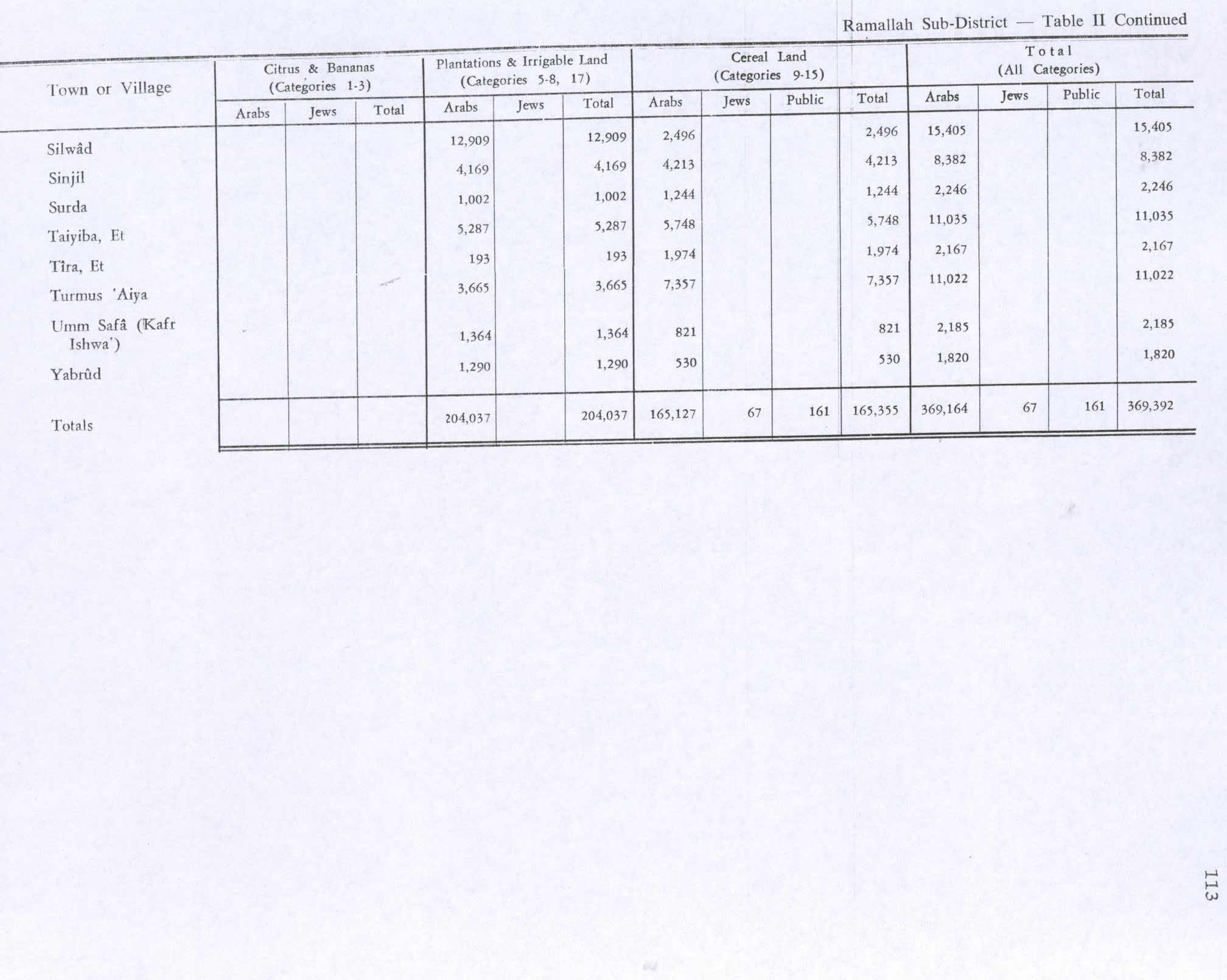
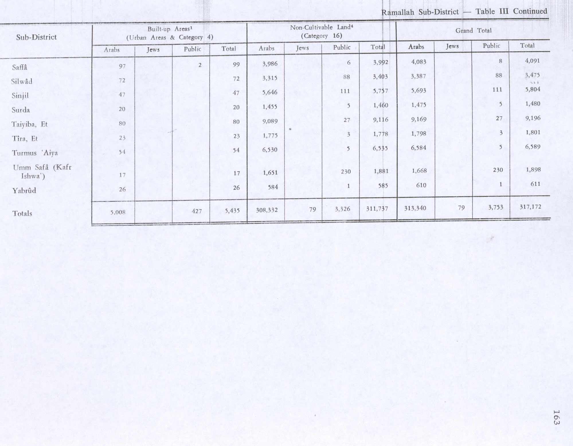
In the 1945 statistics the population of Surda was 250 Muslims,[13] while the total land area was 3,726 dunams, according to an official land and population survey.[14] Of this, 1,002 dunums were used for plantations and irrigable land, 1,244 for cereals,[15] while 20 dunams were classified as built-up areas.[16]
Jordanian era[edit]
In the wake of the 1948 Arab–Israeli War, and after the 1949 Armistice Agreements, Surda came under Jordanian rule.
The Jordanian census of 1961 found 415 inhabitants in Surda.[17]
1967-present[edit]
After the Six-Day War in 1967, Surda has been under Israeli occupation.
After the 1995 accords, 95.4% of village land has been defined as Area B land, while the remaining 4.6% is Area C.[18]
Surda is the birthplace of the Palestinian diplomat Hasan Abdel Rahman.
Footnotes[edit]
- ^ a b Preliminary Results of the Population, Housing and Establishments Census, 2017 (PDF). Palestinian Central Bureau of Statistics (PCBS) (Report). State of Palestine. February 2018. pp. 64–82. Retrieved 2023-10-24.
- ^ a b Surda Village Profile, ARIJ, p. 4
- ^ Palmer, 1881, p. 245
- ^ a b Finkelstein et al, 1997, pp. 423-424
- ^ Hütteroth and Abdulfattah, 1977, p. 117
- ^ Robinson and Smith, 1841, vol 3, Appendix 2, p. 124
- ^ Socin, 1879, p. 161. It was also noted to be in the Beni Harit district.
- ^ Hartmann, 1883, p. 126 also noted 13 houses
- ^ Conder and Kitchener, 1882, SWP II, p. 295. They further noted: "The name suggests its identity with Zereda, the native town of Jeroboam, (1 Kings 11:26)", but based on archeological evidence, Finkelstein et al, 1997, p. 424 thinks this is irrelevant.
- ^ Schick, 1896, p. 123
- ^ Barron, 1923, Table VII, Sub-district of Ramallah, p. 17
- ^ Mills, 1932, p. 51.
- ^ Government of Palestine, Department of Statistics, 1945, p. 26
- ^ Government of Palestine, Department of Statistics. Village Statistics, April, 1945. Quoted in Hadawi, 1970, p. 65
- ^ Government of Palestine, Department of Statistics. Village Statistics, April, 1945. Quoted in Hadawi, 1970, p. 113
- ^ Government of Palestine, Department of Statistics. Village Statistics, April, 1945. Quoted in Hadawi, 1970, p. 163
- ^ Government of Jordan, Department of Statistics, 1964, p. 24
- ^ Surda Village Profile, ARIJ, p. 15
Bibliography[edit]
- Barron, J.B., ed. (1923). Palestine: Report and General Abstracts of the Census of 1922. Government of Palestine.
- Conder, C.R.; Kitchener, H.H. (1882). The Survey of Western Palestine: Memoirs of the Topography, Orography, Hydrography, and Archaeology. Vol. 2. London: Committee of the Palestine Exploration Fund.
- Finkelstein, I.; Lederman, Zvi, eds. (1997). Highlands of many cultures. Vol. 1. Tel Aviv: Institute of Archaeology of Tel Aviv University Publications Section. ISBN 965-440-007-3.
- Government of Jordan, Department of Statistics (1964). First Census of Population and Housing. Volume I: Final Tables; General Characteristics of the Population (PDF).
- Government of Palestine, Department of Statistics (1945). Village Statistics, April, 1945.
- Hadawi, S. (1970). Village Statistics of 1945: A Classification of Land and Area ownership in Palestine. Palestine Liberation Organization Research Center.
- Hartmann, M. (1883). "Die Ortschaftenliste des Liwa Jerusalem in dem türkischen Staatskalender für Syrien auf das Jahr 1288 der Flucht (1871)". Zeitschrift des Deutschen Palästina-Vereins. 6: 102–149.
- Hütteroth, Wolf-Dieter; Abdulfattah, Kamal (1977). Historical Geography of Palestine, Transjordan and Southern Syria in the Late 16th Century. Erlanger Geographische Arbeiten, Sonderband 5. Erlangen, Germany: Vorstand der Fränkischen Geographischen Gesellschaft. ISBN 3-920405-41-2.
- Mills, E., ed. (1932). Census of Palestine 1931. Population of Villages, Towns and Administrative Areas. Jerusalem: Government of Palestine.
- Palmer, E.H. (1881). The Survey of Western Palestine: Arabic and English Name Lists Collected During the Survey by Lieutenants Conder and Kitchener, R. E. Transliterated and Explained by E.H. Palmer. Committee of the Palestine Exploration Fund.
- Robinson, E.; Smith, E. (1841). Biblical Researches in Palestine, Mount Sinai and Arabia Petraea: A Journal of Travels in the year 1838. Vol. 3. Boston: Crocker & Brewster.
- Schick, C. (1896). "Zur Einwohnerzahl des Bezirks Jerusalem". Zeitschrift des Deutschen Palästina-Vereins. 19: 120–127.
- Socin, A. (1879). "Alphabetisches Verzeichniss von Ortschaften des Paschalik Jerusalem". Zeitschrift des Deutschen Palästina-Vereins. 2: 135–163.
External links[edit]
- Surda genealogy: Family frees, Surda.net
- Welcome To Surda
- Survey of Western Palestine, Map 14: IAA, Wikimedia commons
- Surda (fact sheet), Applied Research Institute–Jerusalem (ARIJ)
- Surda Village Profile, ARIJ
- Surda (aerial photo), ARIJ
- Locality Development Priorities and Needs in Surda Village, ARIJ

| Authority control databases: National |
|---|