
Sde Ya'akov
Sde Ya'akov
שְׂדֵה יַעֲקֹב | |
|---|---|
 Road entrance to Sde Ya'akov | |
| Etymology: Ya'akov's Field | |
 Sde Ya'akov | |
| Coordinates: 32°41′48″N 35°8′28″E / 32.69667°N 35.14111°E | |
| Country | Israel |
| District | Northern |
| Council | Jezreel Valley |
| Affiliation | Hapoel HaMizrachi |
| Founded | 1927 |
| Population (2022)[1] | 1,096 |
Sde Ya'akov (Hebrew: שְׂדֵה יַעֲקֹב, lit. Ya'akov Field) is a religious moshav in northern Israel. Located near Kiryat Tiv'on, it falls under the jurisdiction of Jezreel Valley Regional Council. In 2022 it had a population of 1,096.[1]
History[edit]
Sde Ya'akov was established in 1927, largely from pioneers who had settled in Sheikh Abreik after its purchase by the Jewish Agency.[2] It was the first settlement founded by Hapoel HaMizrachi and was named for Yitzchak Yaacov Reines, founder of the Mizrachi movement.
-
 Sde Ya’akov 1928
 -
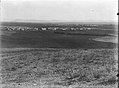 Sde Ya’akov 1935
 -
 Sde Ya’akov 1945
 -
 Sde Ya’akov 1947
 -
 A sign at the entrance to Sde Ya'akov


Ancient site of Tel Yizhaki[edit]
Several kilometers to the southwest, lies an unexcavated tell named Tel Yizhaki or Hurvat Izhaqia. Among the discoveries at this site is a column base featuring an Aramaic inscription in the Jewish script, mentioning a donor named "Yudah son of Sardah". It is believed that the inscription was part of an ancient synagogue.[3]
References[edit]
- ^ a b "Regional Statistics". Israel Central Bureau of Statistics. Retrieved 21 March 2024.
- ^ Ya'akobi, Yoel (11 September 2007). "Youth of the hills of Sheikh Abreik" (in Hebrew). Arutz 7. Retrieved 31 January 2021.
- ^ "CXXIX. Ḥ. Izḥaqia no. 7362", Volume 5/Part 2 Galilaea and Northern Regions: 6925-7818, De Gruyter, pp. 1454–1455, 2023-03-20, doi:10.1515/9783110715743-015, ISBN 978-3-11-071574-3, retrieved 2024-02-07
External links[edit]
- The official website of Sde Yaakov (in Hebrew)
- Sde Yaakov at the Galilee Development Authority website (in Hebrew)
- Moshav Sde Ya'akov Collection (in Hebrew) on the Digital collections of Younes and Soraya Nazarian Library, University of Haifa
| Authority control databases: National |
|---|