
Rheinsteig
Route map:
This article needs additional citations for verification. (January 2024) |
| Rheinsteig | |
|---|---|
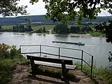
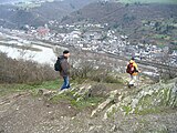
 View of the river Rhine | |
| Length | 320 km (200 mi) |
| Location | Rhineland-Palatinate/Hesse/North Rhine-Westphalia, Germany |
| Trailheads | Bonn,[coord 1] Wiesbaden[coord 2] |
| Use | Hiking |
| Elevation change | 9,500 m (31,200 ft) |
| Highest point | Lykershausen, 351 m (1,152 ft) |
| Lowest point | Kennedy Bridge, Bonn, 60 m (200 ft) |
| Difficulty | Easy |
| Season | All year |
| Sights | Numerous castles along the Rhine Gorge and Siebengebirge. Vineyards of Rheingau. Woodland in Naturpark Rhein-Taunus. |
| Hazards | Cyclists |
| Website | www.rheinsteig.de |
The Rheinsteig is a hiking trail following a mainly elevated path along the east bank of the Rhine River in Germany.[1] Its 320 kilometres (200 mi) route stretches from Bonn to Wiesbaden, running parallel to the Rheinhöhenweg Trail and Rheinburgenweg Trail.
Description[edit]

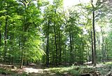
The Rheinsteig passes through woodlands and vineyards, and has challenging ascents and descents.[citation needed] It is signposted by signs with an 'R' on a blue background. The Rheinsteig allows either longer-distance hiking or a number of short tours.[citation needed]
Route and sights of interest[edit]
- Wiesbaden-Biebrich, Schloss Biebrich,[coord 3] Wiesbaden-Schierstein, Goethestein, Burg Frauenstein,[coord 4] Wiesbaden-Frauenstein
- Schlangenbad,[coord 5] Burg Scharfenstein, Kiedrich,
- Eberbach Abbey (Kloster Eberbach),[coord 6] Steinberg, Schloss Vollrads
- Johannisberg (Geisenheim), Schloss Johannisberg,
- Marienthal Monastery, Eibingen Abbey,
- Rüdesheim am Rhein, Niederwalddenkmal,[coord 7] Assmannshausen
- Lorch, Ruine Nollig, Burg Gutenfels[coord 8]
- Kaub, Dörscheid, Lorelei
- Sankt Goarshausen, Nochern, Burg Maus
- Kestert, Lykershausen, Burg Liebenstein, Burg Sterrenberg,[coord 9] Filsen
- Osterspai,[coord 10] Marksburg
- Braubach
- Lahnstein, Oberlahnstein, Niederlahnstein, Lahneck Castle[coord 11]
- Koblenz-Ehrenbreitstein, Ehrenbreitstein Fortress[coord 12]
- Vallendar
- Sayn (part of Bendorf)
- Rengsdorf
- Leutesdorf
- Rheinbrohl
- Leubsdorf, Linz am Rhein
- Unkel[coord 13]
- Bad Honnef, Drachenfels
- Königswinter
- Niederdollendorf
- Kennedy Bridge,[coord 14] Bonn
Literature and maps[edit]
Opened on September 8, 2005, hikers can find maps and books giving information about where to join and leave the track, should hikers want to do just a short section.[tone]
| Coordinate list |
|---|
|
Gallery[edit]
- Rheinsteig
-
-

-

-
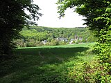
 Arenfels castle
 -

-
 Honigberg near Kiedrich
 -
 Eberbach Abbey
 -
 The Rheinsteig in winter, Roßstein between Kaub and St. Goarshausen, view of Oberwesel
 -
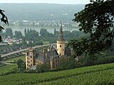
 Goethestein, Wiesbaden-Frauenstein


References[edit]
- ^ e.V, Deutsche Zentrale für Tourismus. "The Rheinsteig Trail - the UNESCO World Heritage Site - Germany Travel". www.germany.travel. Retrieved 2024-01-16.
KML is from Wikidata
External links[edit]
Wikimedia Commons has media related to Rheinsteig.
Wikivoyage has a travel guide for Rheinsteig.
- www.rheinsteig.de Official website
- The Rhine Trail - Rheinsteig
- loreley-info
- GPS track and tour guide
| International | |
|---|---|
| National | |