
Portal:Western Australia
Introduction
 Western Australia (commonly abbreviated as WA) is a state of Australia occupying the western third of the land area of Australia, excluding external territories. It is bounded by the Indian Ocean to the north and west, the Southern Ocean to the south, the Northern Territory to the north-east, and South Australia to the south-east. Western Australia is Australia's largest state, with a total land area of 2,527,013 square kilometres (975,685 sq mi). It is the second-largest country subdivision in the world, surpassed only by Russia's Sakha Republic. the state has 2.76 million inhabitants—11 percent of the national total. The vast majority (92 percent) live in the south-west corner; 79 percent of the population lives in the Perth area, leaving the remainder of the state sparsely populated. The first Europeans to visit Western Australia belonged to the Dutch Dirk Hartog expedition, who visited the Western Australian coast in 1616. The first permanent European colony in what is today Western Australia occurred following the landing by Major Edmund Lockyer on 26 December 1826 of an expedition on behalf of the New South Wales colonial government.[text–source integrity?] Lockyer established a convict-supported military garrison at King George III Sound, at present-day Albany, and on 21 January 1827 he formally took possession for the British Crown of the western part of the continent that was not already claimed by the Crown. This was followed by the establishment of the Swan River Colony in 1829, including the site of the present-day capital, Perth. (Full article...)
|


.JPG)


(Northern
Territory) |
 Good articles -
-
 "Showdown" is the fourth single and first track from the album In Silico by Australian electronic rock band Pendulum. It has been remixed by several artists, including DJ Clipz (who is also Red Light) and Excision. It is also the first single taken from In Silico not to use the album logo prominently on its cover.
The single was originally released through various online music stores on 5 January 2009. It was not available in any physical format until 9 February, when Warner Music UK released the 12-inch picture disc of "Showdown". To help promote the single, Pendulum also released a Space Invaders themed video game which offered players a chance of winning an official framed gold disc of In Silico. (Full article...) -
Collier Road is a 4.7-kilometre (2.9 mi) main road in the north-eastern suburbs of Perth, Western Australia, linking Morley in the north-west to Bassendean in the south-east. It services an industrial area in Bayswater and Bassendean, the Morley business district, and connects to Tonkin Highway. Collier Road first existed as a gravel track in the 1910s. The 1950s and 1960s saw the land around Collier Road change from rural to urban. It has undergone a major realignment twice, first in the mid-1980s to make room for a larger shopping centre in Morley, and between 2016 and 2018, for the construction of an interchange with Tonkin Highway. (Full article...) -
On 26 June 1950, a Douglas DC-4 Skymaster aircraft departed from Perth, Western Australia, for an eight-hour flight to Adelaide, South Australia. It crashed 22 minutes after take-off, 35 miles (56 km) east of Perth Airport. All 29 occupants were killed in the accident; one initially survived, but died six days later. It was the worst civil aviation accident in Australia.
As the aircraft flew eastwards over the outer suburbs of Perth numerous witnesses observed that it was flying at a lower altitude than usual for the daily Skymaster services, and at least one of the engines was running roughly and backfiring at regular intervals. In the minutes before it crashed, witnesses heard a number of different engine noises – sometimes operating normally, sometimes all engine noise ceased, only to be replaced by what was described as a very loud, high-pitched "scream". When the wrecked engines were examined many weeks after the accident a significant amount of corrosion product was found in the fuel system within two of the engines. After a preliminary investigation, Investigators from the Department of Civil Aviation believed the water responsible for the corrosion was also responsible for rough running of at least one engine, and ultimately temporary loss of power from all engines on at least one occasion. The investigators did not find a likely source for the water. (Full article...) -

Severe Tropical Cyclone Alby was regarded as the most devastating tropical cyclone to impact southwestern Western Australia on record. Forming out of an area of low pressure on 27 March 1978, Alby steadily developed as it tracked southwestward, parallel to Western Australia. Between 1 and 2 April, the storm quickly intensified and attained its peak intensity as a Category 5 cyclone on the Australian cyclone intensity scale. After turning to the southeast, the storm underwent an extratropical transition as it neared Cape Leeuwin. The storm brushed the cape on 4 April, bringing hurricane-force winds, before rapidly losing its identity the following day.
In Western Australia, the combination of Alby's fast movement and hurricane-force winds caused widespread damage. Along the coast, large swells flooded low-lying areas and numerous homes lost their roofs from high winds. Further inland, bushfires were worsened by the storm as it brought little rain, generally less than 20 mm (0.79 in) along the coast. These fires burned roughly 114,000 hectares (281,700 acres) and destroyed two towns. Five fatalities are attributed to Alby and the associated brushfires. The resulting damage was extensive, with monetary losses reaching A$50 million (US$45 million). (Full article...) -
Eyre Highway is a 1,664-kilometre (1,034 mi) highway linking Western Australia and South Australia via the Nullarbor Plain. Signed as National Highways 1 and A1, it forms part of Highway 1 and the Australian National Highway network linking Perth and Adelaide. It was named after explorer Edward John Eyre, who was the first European to cross the Nullarbor by land, in 1840–1841. Eyre Highway runs from Norseman in Western Australia, past Eucla, to the state border. Continuing to the South Australian town of Ceduna, it crosses the top of the Eyre Peninsula before reaching Port Augusta.
The construction of the East–West Telegraph line in the 1870s, along Eyre's route, resulted in a hazardous trail that could be followed for interstate travel. A national highway was called for, with the federal government seeing the route's importance in 1941, when a war in the Pacific seemed imminent. The highway was constructed between July 1941 and June 1942, and was trafficable by January 1942. It was originally named Forrest Highway, after John Forrest, by the war cabinet. It was officially named Eyre Highway, a name agreed upon by the states' nomenclature committees. (Full article...) -
Raymond James O'Connor (6 March 1926 – 25 February 2013) was an Australian politician who served as the premier of Western Australia from 25 January 1982 to 25 February 1983. He was a member of the Parliament of Western Australia from 1959 to 1984, and a minister in the governments of David Brand and Charles Court. O'Connor was born in Perth and attended schools in the Wheatbelt towns of Narrogin and York as well as St Patrick's Boys' School in Perth, leaving school at the age of 14. He competed in athletics and played Australian rules football as a teenager and young adult, including playing 14 matches for East Perth in the Western Australian National Football League. During World War II, he served in the Second Australian Imperial Force in New Britain and Bougainville.
O'Connor joined the Liberal Party in 1957 and was elected to the Western Australian Legislative Assembly in 1959. From 1965 to 1971, he was a minister in the Brand government. During this time, he served as the minister for railways and minister for transport, in which he oversaw the gauge standardisation project of the railway between Perth and Kalgoorlie. He became a minister again when Court was elected premier in 1974. He was police minister when the murder of Shirley Finn occurred in 1975, which remains unsolved but was likely done by a corrupt police officer. (Full article...) -
Oats Street railway station is a temporarily-closed Transperth suburban railway station in Western Australia, located in the Perth suburbs of Carlisle and East Victoria Park. The station was served by the Armadale and Thornlie lines prior to its closure in November 2023.
Oats Street station opened on 28 November 1954, as the introduction of diesel railcars made it possible to build stations closer together. The station consisted of two side platforms north of the Oats Street level crossing. The CircleRoute bus began operating in 1998, allowing access to Curtin University from the Armadale line. A bus interchange was constructed soon thereafter, and Oats Street soon became one of the most important stations on the Armadale line. The Thornlie line opened in 2005, with Oats Street station being one of the few transfer stations between the two lines, further increasing its importance. Since 20 November 2023, the station has been closed to allow for the railway to be elevated and for Oats Street station to be rebuilt as an elevated station, as part of the Victoria Park-Canning Level Crossing Removal Project. The new station will straddle Oats Street and feature an expanded bus interchange. It is planned to reopen in mid-2025. (Full article...) -
North West Coastal Highway is a generally north-south Western Australian highway which links the coastal city of Geraldton with the town of Port Hedland. The 1,300-kilometre-long (808 mi) road, constructed as a sealed two-lane single carriageway, travels through remote and largely arid landscapes. Carnarvon is the only large settlement on the highway, and is an oasis within the harsh surrounding environment. The entire highway is allocated National Route 1, part of Australia's Highway 1, and parts of the highway are included in tourist routes Batavia Coast Tourist Way and Cossack Tourist Way. Economically, North West Coastal Highway is an important link to the Mid West, Gascoyne and Pilbara regions, supporting the agricultural, pastoral, fishing, and tourism industries, as well as mining and offshore oil and gas production.
In Geraldton, the highway begins at a grade separated interchange with Brand Highway and roads providing access to the port and town centre. Two major roads link the North West Coastal Highway to the inland Great Northern Highway: Geraldton–Mount Magnet Road in Geraldton, and Nanutarra Munjina Road at Nanutarra, 845 kilometres (525 mi) further north. Several roads link provide access to coastal towns and attractions, including Shark Bay Road, Onslow Road and Karratha Road. With few towns on the highway, roadhouses are the only settlements for long stretches. North West Coastal Highway ends at Great Northern Highway, 30 kilometres (19 mi) out from Port Hedland. (Full article...) -
The First Commonwealth Paraplegic Games were held in Perth, Western Australia, from 10 to 17 November 1962. These Games preceded the 1962 British Empire and Commonwealth Games which were held in Perth from 22 November to 1 December of that year. The Commonwealth Paraplegic Games were conceived by George Bedbrook after Perth won the right to host the Commonwealth Games. Great support was received from Royal Perth Hospital, a leading spinal rehabilitation centre in Australia.
These games raised the profile of paraplegic (spinal cord and polio) athletes in Australia, particularly Western Australia. The chairman of the Organising Committee, Hugh Leslie, who had lost a leg in World War II, gave a speech aimed to change public perceptions about disabilities by addressing the power of language. These games, he told the audience, "were designed to prove to the public that the person who was bodily handicapped was not a cripple, and he hoped that that horrible word would eventually be wiped out of use. He had a slogan which he hoped would be adopted by all disabled: 'I can, I will'". (Full article...) -
Severe Tropical Cyclone Sam (JTWC designation: 03S) was an intense tropical cyclone that brought flooding rainfall to a wide swath of northern Australia in December 2000. The first tropical cyclone of the regional season, Sam originated from a tropical low that formed in the Arafura Sea on 28 November. Tracking generally westward, the initial low-pressure area remained generally weak until it entered the Timor Sea, by which time it had strengthened into a tropical cyclone on 5 December. Though a subtropical ridge was forcing the cyclone westward at the time, an approaching shortwave trough caused Sam to track southward the following day, towards the Australian coast. During its southward progression, Sam rapidly intensified, and reached its peak intensity on 8 December. Soon afterwards, the storm made landfall near Lagrange, Western Australia at the same intensity. Once inland, Sam was slow to weaken as it re-curved eastward, and persisted for nearly a week inland before dissipating on 14 December.
Throughout its existence, Cyclone Sam brought heavy rainfall to a wide swath of northern Australia. Rainfall peaked at 520 mm (20 in) in Shelamar over a 48-hour period ending on 11 December. Upon making landfall, damage was considerable, albeit localized. Most of the destruction wrought by Sam occurred near the coast, particularly in Bidyadanga and Anna Springs Station. Some buildings sustained considerable damage, and trees and power lines were felled, resulting in some power outages. Offshore, 163 illegal immigrants aboard two vessels were feared to have drowned, which would make Sam one of the deadliest cyclones in Australian history. However, these people were later accounted for. After the season, the name Sam was retired from the regional naming list. (Full article...) -

The western rosella (Platycercus icterotis), or moyadong, is a species of parrot endemic to southwestern Australia. The head and underparts are bright red, and the back is mottled black; a yellow patch at the cheek distinguishes it from others of the genus Platycercus. Adults of the species exhibit sexual dimorphism with the females duller overall; juveniles lack the striking colours of mature birds and the characteristic patterning is not as easily distinguished. Their communication call is a softly delivered pink-pink sound, and much of their behaviour is comparatively unobtrusive. Their habitat is in eucalypt forests and woodlands, where they often remain unobserved until they appear to feed on seeds at nearby cleared areas.
Individuals form mating pairs and generally remain in one locality, although they will venture out to join small groups at plentiful sources of food. The western rosella is predominantly herbivorous, its diet consisting mostly of seeds of grasses and other plants, although nectar and insect larvae are sometimes eaten. The damage attributed to the species at introduced fruit and grain crops saw them declared as a pest and permitted by the state to be killed or captured. They are more placid and sociable than rosellas of other Australian regions from which they are geographically isolated and have become internationally popular as an aviary bird. Their history in aviculture begins with two 1830 lithographs of live specimens in England by Edward Lear. Successful breeding in captivity began there during the early 20th century. (Full article...) -

The 2010 Gascoyne River flood was regarded as the most severe flood to take place along the Gascoyne River in Western Australia on record. Triggered by record-breaking rainfall, amounting to over 6,000 percent of the monthly mean, 313.6 mm (12.35 in) and 5 mm (0.20 in) respectively, in just four days, the floods caused widespread damage in the region. By 17 December, the river began to rise in response to the heavy rains, eventually exceeding its banks within two days. Water levels reached record values at three stations along the river, cresting at 15.53 m (51.0 ft) near Fishy Pool. Evacuation orders were issued for several towns affected by rising waters. The most substantial impact was felt in Carnarvon where entire homes were washed away. Following the disaster, emergency supplies and funds were distributed to affected residents to aid them in restoring their livelihoods. Though no people died in the event, an estimated two thousand head of cattle perished and damage was estimated at A$100 million. (Full article...) -
Lauren Stephanie Mitchell OAM (born 23 July 1991) is an Australian former artistic gymnast. She is the 2010 World champion on the floor exercise and the 2009 World Championships silver medalist on the balance beam and floor exercise. Mitchell is only the second Australian female gymnast to win a medal at the World Championships, and she is the first to win a gold medal. She is the 2010 Commonwealth Games champion in the all-around, uneven bars, and balance beam, and with the Australian team, and she is the 2008 World Cup Final balance beam champion. She also represented Australia at the 2008 and 2012 Olympic Games.
In her first year of senior competition, Mitchell qualified for the balance beam event final at the 2007 World Championships. Then at the 2008 Summer Olympics, she helped the Australian team place sixth, their highest finish ever. She then became the first Australian gymnast to win more than one medal at the same World Championships when she won two silver medals in 2009. The next year, she tied the record for the most gold medals won by a female gymnast at a single Commonwealth Games and became Australia's first female World champion in gymnastics. At her second Olympic Games in 2012, she qualified for the floor exercise final and finished fifth. She won two more Commonwealth medals in 2014, silver with the team and on the floor exercise. Mitchell retired from gymnastics in 2016 as Australia's most decorated gymnast. (Full article...) -
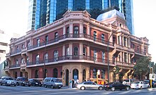
The Palace Hotel in Perth, Western Australia, is a landmark three-storey heritage listed building located in the city's central business district. Originally built in 1897 as a hotel during the gold rush period of Western Australia's history, it was converted to banking chambers and offices in the 1980s and now accommodates the Perth headquarters of Woods Bagot, Adapptor and Hatchd. The building is located on the most prominent intersection in the financial district of the city, at the corner of St Georges Terrace and William Street.
When the hotel opened for business on 18 March 1897 it was, although slightly smaller than some of its contemporary buildings in other capital cities in Australasia, described as "... one of the most beautiful and elegant hotels in Australasia". Other praise included: "... redolent of the bourgeois luxury and splendour of the Paris of Napoleon III" and later "... in its day, as sumptuous a hostelry as any in Melbourne or Sydney." It operated as licensed premises from 1897 until 1981. (Full article...) -
Linda Yunkata Syddick Napaltjarri (born c. 1937) is a Pintupi- and Pitjantjatjara- speaking Indigenous artist from Australia's Western Desert region. Her father was killed when she was young; her mother later married Shorty Lungkarta Tjungarrayi, an artist whose work was a significant influence on Linda Syddick's painting.
Linda Syddick was one of many Western Desert women who took up painting in the early 1990s, as part of a broader contemporary Indigenous Australian art movement. She began painting some time prior to 1991, when her work was first exhibited in Alice Springs. Her work includes a distinctive fusion of Christian and Aboriginal traditional themes and motifs. She has been a finalist in the National Aboriginal & Torres Strait Islander Art Awards on at least four occasions, and in the Blake Prize (a religious art competition) at least three times. Her works are held by numerous galleries including the National Gallery of Australia, the Art Gallery of New South Wales and the Art Gallery of South Australia. Linda Syddick was the subject of a portrait painted by Robert Hannaford, which was a 1992 finalist in Australia's premiere portrait competition, the Archibald Prize. (Full article...)


.jpg)


Did you know (auto-generated)

- ... that politician John D'Orazio helped to secure a three-year trial of daylight saving time in Western Australia?
- ... that Western Australia was the second Australian state to legalise voluntary assisted dying?
- ... that the search for a lost radioactive capsule along a 1,400-kilometre (870 mi) stretch of road in Western Australia was likened to looking for a needle in a haystack?
- ... that Bill Dunn, an Indigenous Australian pastoralist approaching retirement, sold his station at half-price to the Jigalong community despite receiving full-price offers from non-Indigenous people?
- ... that Nick Goiran, a member of the Western Australian Legislative Council, proposed 357 amendments to a voluntary assisted dying bill?
- ... that Mertome Village in Bayswater, Western Australia was the first aged care complex to be built by a local government in Australia?
Categories

More portals
More did you know...

- ...that when the 1987 America's Cup was raced off Fremantle, Western Australia it was the first time for 132 years that the regatta had not been hosted by the New York Yacht Club?
- ...that the original Victoria Dam, constructed in 1891, was the first dam in Western Australia, and it stood for almost 100 years before being replaced with the current dam?
- ...that Anglican bishop Kay Goldsworthy was consecrated as the first woman bishop of any Australian church on 22 May 2008?
Related WikiProjects

Things you can do
Here are some tasks you can do to help with WikiProject Western Australia:
Associated Wikimedia
The following Wikimedia Foundation sister projects provide more on this subject:
-
 Commons
Free media repository -
 Wikibooks
Free textbooks and manuals -
 Wikidata
Free knowledge base -
 Wikinews
Free-content news -
 Wikiquote
Collection of quotations -
 Wikisource
Free-content library -
 Wikispecies
Directory of species -
 Wikiversity
Free learning tools -
 Wikivoyage
Free travel guide -
 Wiktionary
Dictionary and thesaurus


