
Molinopampa District
Molinopampa | |
|---|---|
 Church of Molinopampa | |
| Coordinates: 6°11′45″S 77°38′15″W / 6.19583°S 77.63750°W | |
| Country | |
| Region | Amazonas |
| Province | Chachapoyas |
| Founded | February 5, 1861 |
| Capital | Molinopampa |
| Government | |
| • Mayor | Zonia María Negron Tafur |
| Area | |
| • Total | 333.86 km2 (128.90 sq mi) |
| Elevation | 2,407 m (7,897 ft) |
| Population | |
| • Total | 2,583 |
| • Density | 7.7/km2 (20/sq mi) |
| Time zone | UTC-5 (PET) |
| UBIGEO | 010114 |
Molinopampa is a district of the Chachapoyas Province, Peru. The district is located at an altitude of 2,407 m above sea level, covers an area of 400 km2. It is located at the right bank of the Ventilla River.
Molinopampa offers several attractive places, like ruins and the River Sonche that invites to remain or go fishing, that's why also the trout is rich well in this place.
To the north the district borders the Quinjalca District (Chachapoyas) and Granada District (Chachapoyas), to the southeast with the Longar District, to the south-west the Cheto District (Chachapoyas).
Gallery[edit]
-
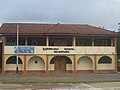 Municipalidad de Molinopampa
 -
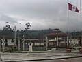 Main square of Molinopampa
 -
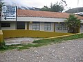 Health center of Molinopampa
 -
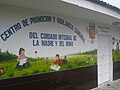 Centro de Promocion y Vigilancia Comunal del Cuidado Integral de la Madre y del Nino


| |
|---|---|
| Bagua | |
| Bongará | |
| Chachapoyas | |
| Condorcanqui | |
| Luya | |
| Rodríguez de Mendoza | |
| Utcubamba | |
This Amazonas geography article is a stub. You can help Wikipedia by expanding it. |