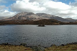
Loch Stack
| Loch Stack | |
|---|---|
 Loch Stack | |
| Location | Sutherland, Scotland |
| Coordinates | 58°20′12″N 4°55′28″W / 58.336700°N 4.924500°W[1] |
| Type | freshwater loch |
| Primary inflows | An Earachd[2] |
| Primary outflows | River Laxford [2] |
| Basin countries | Scotland |
| Max. length | 4 km (2.5 mi)[2] |
| Surface area | 252.1 ha (623 acres)[1] |
| Average depth | 26 m (86 ft)[2] |
| Max. depth | 33 m (108 ft)[2] |
| Water volume | 28,000,000 m3 (988,000,000 cu ft)[2] |
| Shore length1 | 16.6 km (10.3 mi)[1] |
| Surface elevation | 46 m (151 ft)[1] |
| Islands | 1[1] |
| 1 Shore length is not a well-defined measure. | |
Loch Stack is a large, irregularly shaped freshwater loch in the Northwest of Scotland. It lies approximately 4 miles (6.4 km) southeast of Laxford Bridge and is surrounded by mountains. Ben Stack rises steeply from the loch's southwestern shore and Arkle lies directly to the north. The outflow from Loch More, which is about 1 mile (1.6 km) south of Loch Stack, is carried (via Loch nan Ealachan) by the small river An Earachd into Loch Stack.
Survey[edit]
The loch was surveyed[2] between 6 and 8 September 1902 by T.N. Johnston and James Murray and later charted[3] as part of the Sir John Murray's Bathymetrical Survey of Fresh-Water Lochs of Scotland 1897-1909.
References[edit]
- ^ a b c d e "Loch Stack". British lakes. British Lakes. Retrieved 6 May 2015.
- ^ a b c d e f g "Bathymetrical Survey of the Fresh-Water Lochs of Scotland, 1897-1909, Lochs of the Laxford Basin". National Library of Scotland. Retrieved 6 May 2015.
- ^ "Loch Stack (Laxford Basin) (Vol. 5, Plate 9) - Bathymetrical Survey, 1897-1909 - National Library of Scotland". National Library of Scotland. Retrieved 6 May 2015.

