
Kloetinge
Kloetinge | |
|---|---|
Village | |
 | |
 Coat of arms | |
 Kloetinge Location in the province of Zeeland in the Netherlands  Kloetinge Kloetinge (Netherlands) | |
| Coordinates: 51°29′55″N 3°54′48″E / 51.49861°N 3.91333°E | |
| Country | Netherlands |
| Province | Zeeland |
| Municipality | Goes |
| Area | |
| • Total | 7.77 km2 (3.00 sq mi) |
| Elevation | 0.5 m (1.6 ft) |
| Population (2021)[1] | |
| • Total | 3,440 |
| • Density | 440/km2 (1,100/sq mi) |
| Time zone | UTC+1 (CET) |
| • Summer (DST) | UTC+2 (CEST) |
| Postal code | 4481[1] |
| Dialing code | 0113 |
Kloetinge is a village in the Dutch province of Zeeland. It is located in the municipality of Goes, on the eastern side of the city.
History[edit]
The village was first mentioned in 1216 as Clotinge, and means "settlement with a height".[3] Kloetinge is a circular village which developed on a terp (artificial living hill) with an adjacent market square with drinking well for cattle. The motte-and-bailey castle of the Lords of Kloetinge was located on the eastern side of the market. The original village was destroyed in 1572 by the Geuzen.[4]
The Dutch Reformed church was built between 1275 and 1300 to replace a wooden church. The church was enlarged and modified several times. The tower was restored in 1956, and the church between 1969 and 1973. The former town hall and clergy house were built in 1881 and designed by the same architect. In 1968, the clergy house was incorporated into the town hall. In 1984, the building was converted into an apartment building.[4]
The grist mill Oostmolen was built in 1704. Until the 1960s, it formed a single building with the residential home of the miller. In 1998, the wind mill became owned by a foundation, and is regularly in service.[5]
Kloetinge was home to 696 people in 1840.[6] In 1927, a railway station was built on the Goes to Wemeldinge railway. It closed in 1934.[7] Kloetinge was a separate municipality until 1970, when it was merged with Goes.[8]
Sports[edit]
Kloetinge is home to football club VV Kloetinge.[9]
Gallery[edit]
-
 Gertrudis church, front (west)
 -
 Gertrudis church
 -
 The Kloetinge windmill
 -
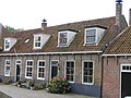 Houses in Kloetinge


References[edit]
- ^ a b c "Kerncijfers wijken en buurten 2021". Central Bureau of Statistics. Retrieved 19 April 2022.
- ^ "Postcodetool for 4481AA". Actueel Hoogtebestand Nederland (in Dutch). Het Waterschapshuis. 24 July 2019. Retrieved 19 April 2022.
- ^ "Kloetinge - (geografische naam)". Etymologiebank (in Dutch). Retrieved 19 April 2022.
- ^ a b Piet van Cruyningen & Ronald Stenvert (2003). Kloetinge (in Dutch). Zwolle: Waanders. ISBN 90-400-8830-6. Retrieved 19 April 2022.
- ^ "Oostmolen". Molen database (in Dutch). Retrieved 19 April 2022.
- ^ "Kloetinge". Plaatsengids (in Dutch). Retrieved 19 April 2022.
- ^ "halte Kloetinge". Stationweb (in Dutch). Retrieved 19 April 2022.
- ^ Ad van der Meer and Onno Boonstra, "Repertorium van Nederlandse gemeenten", KNAW, 2006. "KNAW > Publicaties > Detailpagina". Archived from the original on 2007-02-20. Retrieved 2009-12-03.
- ^ "Dit zijn de indelingen van het Zeeuwse amateurvoetbal". Omroep Zeeland (in Dutch). Retrieved 19 April 2022.