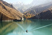
Khersan-3 Dam
| Khersan-3 Dam | |
|---|---|
| Country | Iran |
| Location | Atashgah, Chaharmahal and Bakhtiari Province |
| Coordinates | 31°14′52.51″N 50°58′34.79″E / 31.2479194°N 50.9763306°E |
| Purpose | Power, flood control, regulation |
| Status | Under construction |
| Construction began | 2007 |
| Opening date | 2015 |
| Owner(s) | Iran Water and Power Resources Development Co. |
| Dam and spillways | |
| Type of dam | Arch, double-curvature |
| Impounds | Khersan River |
| Height | 195 m (640 ft) |
| Length | 470 m (1,542 ft) |
| Width (crest) | 6 m (20 ft) |
| Width (base) | 40 m (131 ft) |
| Dam volume | 1,100,000 m3 (1,438,746 cu yd) |
| Spillway type | Controlled |
| Spillway capacity | 6,300 m3/s (220,000 cu ft/s) |
| Reservoir | |
| Creates | Khersan-3 Reservoir |
| Total capacity | 1,158,400,000 m3 (939,130 acre⋅ft) |
| Catchment area | 7,733 km2 (2,986 sq mi) |
| Surface area | 24.5 km2 (9 sq mi) |
| Maximum length | 40 km (25 mi) |
| Maximum width | 400 m (1,312 ft) (average) |
| Normal elevation | 1,432 m (4,698 ft) |
| Power Station | |
| Commission date | 2015 |
| Hydraulic head | 177 m (581 ft) (design) |
| Turbines | 4 x 100 MW Francis-type |
| Installed capacity | 400 MW |
| Annual generation | 1121 GWh [1] |
Khersan-3 dam is an arch dam currently under construction on the Khersan River, a tributary of the Karun River, in Iran. When complete it will have an installed capacity of 400 MW. It is situated near Atashgah in Chaharmahal and Bakhtiari Province and is a complementary dam to Khersan project along with the proposed Khersan-1 and Khersan-2 Dams. Construction began in 2007 and it is expected to become operational in 2015.[2]
See also[edit]
References[edit]
- ^ "Khersan 3 Technical Information". Iran Water and Power Resources Development Co. Archived from the original on 9 May 2015. Retrieved 6 June 2013.
- ^ "Khersan-3 Project Information". Iran Water and Power Resources Development Co. Archived from the original on 14 July 2013. Retrieved 6 June 2013.


