Il-Gelmus
This article needs additional citations for verification. (July 2022) |
| Il-Gelmus | |
|---|---|
 Gelmus as seen from the Cittadella. | |
| Highest point | |
| Elevation | 133 m (436 ft) |
| Coordinates | 36°03′N 14°14′E / 36.050°N 14.233°E |
| Geography | |
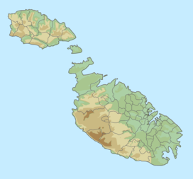
Il-Gelmus is a hill located in Victoria, Gozo, Malta, 1 kilometre away from Victoria's city centre. The estimated terrain elevation above sea level is 133 metres.[1] The width at the base is 0.56 kilometres. In the area around Il-Gelmus are peninsulas, rock formations, beaches and caves.
The coordinates of Il-Gelmus are 36°02'55"N 14°13'58.01"E.[1][2]
This hill has the maximum thickness of greensand layer in the Maltese archipelago. The greensand layer in Gelmus reaches a maximum of 11 metres.[3]
This area is related to the legend of the Golden Calf of Gozo, and is also mentioned in the Maltese poem "L-Għoġol tad-Deheb" by F. X. Mangion that also refers to this same legend.[4]
Climate[edit]
The climate of the area is temperate. Average annual temperature in the neighborhood is 18°C. The warmest month is July when the average temperature is 26°C and the coldest is in January, with 12°C. The average annual rainfall is 581 millimetres. The rainiest month is November, with an average of 157mm of precipitation, and the driest is July, with 1mm of rainfall.
See also[edit]
References[edit]
- ^ a b "Il-Gelmus". geoview.info. Archived from the original on 24 July 2022. Retrieved 24 July 2022.
- ^ "Il-Gelmus". getamap.net. Retrieved 24 July 2022.
- ^ Said, George (May 2004). "A Brief Outline of the Geophysical Properties of the Island of Gozo" (PDF). The Gozo Observer. 10–11. University of Malta, Gozo Campus.: 4–7. Retrieved 31 July 2022 – via OAR@UM, University of Malta.
- ^ Mangion, F. X. (1976). "L-Għoġol tad-Deheb" (PDF). Ġabra ta' kitbiet: Leħen il-Malti (in Maltese) (20). Għaqda tal-Malti – via OAR@UM, University of Malta.

