
Greenwood, Queensland
| Greenwood Queensland | |||||||||||||||
|---|---|---|---|---|---|---|---|---|---|---|---|---|---|---|---|
 Greenwood | |||||||||||||||
| Coordinates | 27°20′12″S 151°44′23″E / 27.3366°S 151.7397°E | ||||||||||||||
| Population | 40 (2016 census)[1] | ||||||||||||||
| • Density | 2.30/km2 (6.0/sq mi) | ||||||||||||||
| Postcode(s) | 4401 | ||||||||||||||
| Area | 17.4 km2 (6.7 sq mi) | ||||||||||||||
| Time zone | AEST (UTC+10:00) | ||||||||||||||
| LGA(s) | Toowoomba Region | ||||||||||||||
| State electorate(s) | Condamine | ||||||||||||||
| Federal division(s) | Groom | ||||||||||||||
| |||||||||||||||
Greenwood is a rural locality in the Toowoomba Region, Queensland, Australia.[2] In the 2016 census, Greenwood had a population of 40 people.[1]
Geography[edit]
The land is freehold and use for agriculture, predominantly cropping.[3]
The Oakey–Cooyar Road runs through the north-western corner.[4]
History[edit]
The first Evangelical Lutheran Church in Queensland opened at Greenwood circa 1900. However, the Greenwood congregation outgrew the building so it was relocated to Yamsion to become its Evangelican Lutheran Church, where it was officially opened and dedicated on Thursday 18 May 1922.[5]
Greenwood Provisional School opened in 1907. On 1 January 1909, it became Greenwood State School. It closed in 1968.[6] It was at 1091 Oakey Cooyar Road (27°20′16″S 151°43′45″E / 27.3379°S 151.7293°E).[7][8]
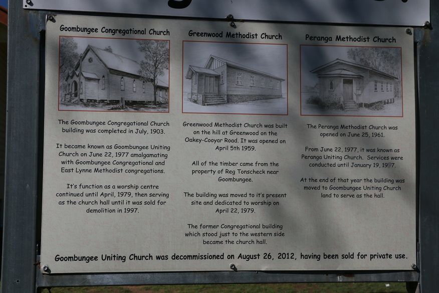
Greenwood Methodist Church opened on 5 April 1959 at the top of the hill on Oakey-Cooyar Road, becoming the Greenwood Uniting Church after the 1977 amalgamation which formed the Uniting Church in Australia. In 1979, the Greenwood church building was relocated to Goombungee to become the Goombungee Uniting Church, while the former Goombungee Uniting Church became the church hall. On 26 August 2012, the former Greenwood church in Goombungee was decommissioned as a church and sold into private ownership.[9][10]
In the 2016 census, Greenwood had a population of 40 people.[1]
References[edit]
- ^ a b c Australian Bureau of Statistics (27 June 2017). "Greenwood (SSC)". 2016 Census QuickStats. Retrieved 20 October 2018.
- ^ "Greenwood – locality in Toowoomba Region (entry 47960)". Queensland Place Names. Queensland Government. Retrieved 29 December 2020.
- ^ "Queensland Globe". State of Queensland. Retrieved 30 December 2017.
- ^ Greenwood, Queensland (Map). OpenStreetMap. Retrieved 18 January 2022.
- ^ "DALBY". The Brisbane Courier. No. 20, 070. Queensland, Australia. 19 May 1922. p. 8. Retrieved 27 February 2021 – via National Library of Australia.
- ^ Queensland Family History Society (2010), Queensland schools past and present (Version 1.01 ed.), Queensland Family History Society, ISBN 978-1-921171-26-0
- ^ "Parish of King County of Aubigny" (Map). Queensland Government. 1942. Archived from the original on 17 December 2020. Retrieved 17 December 2020.
- ^ "Queensland Globe". State of Queensland. Retrieved 16 December 2020.
- ^ "Noticeboard outside Goombungee Uniting Church, 6 George Street". Churches Australia. Archived from the original on 17 December 2020. Retrieved 17 December 2020.
- ^ "Goombungee Uniting Church - Former". Churches Australia. Archived from the original on 17 December 2020. Retrieved 17 December 2020.
Further reading[edit]
- Oakey State School 125th celebration : October 22, 1999, Oakey, Qld., 2003
{{citation}}: CS1 maint: location missing publisher (link) — includes Gowrie Little Plains School, Aubigny School, Crosshill School, Devon Park State School, Silverleigh State School, Boodua School, Greenwood State School, Kelvinhaugh State School