Gainfield
| Gainfield | |
|---|---|
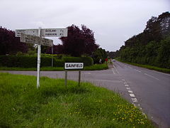
 Gainfield crossroads, with the Warren on the right of the picture | |
Location within Oxfordshire | |
| OS grid reference | SU3495 |
| Civil parish | |
| District | |
| Shire county | |
| Region | |
| Country | England |
| Sovereign state | United Kingdom |
| Post town | Faringdon |
| Postcode district | SN7 |
| Dialling code | 01367 |
| Police | Thames Valley |
| Fire | Oxfordshire |
| Ambulance | South Central |
| UK Parliament | |
Gainfield is a small ribbon development in Buckland civil parish about 4 miles (6.4 km) east of Faringdon in the Vale of the White Horse District of England. It was part of Berkshire until the 1974 boundary changes transferred it to Oxfordshire. Buckland is on the B4508 road by the crossroads with the road between Buckland and Charney Bassett, about 1.5 miles (2.4 km) north of Stanford in the Vale. It is opposite a wood called Buckland Warren. There is a legend, linked with that of nearby Cherbury Camp, that tells of the land being given as a reward to a young shepherd boy who saved the inhabitants of the camp by his vigilance.[1] Gainfield is a modern settlement, developed in the late 20th century on lands belonging to Gainfield Farm.[2] Gainfield Farm appears to represent the meeting place of the hundred of Ganfield, one of the ancient hundreds of Berkshire, known to have been in the parish of Buckland.[3]
References[edit]
- ^ Ford, David Nash (2001). "Gainfield". Royal Berkshire History. Nash Ford Publishing. Retrieved 16 October 2011.
- ^ There was no settlement here in 1959. "Sheet 158 Oxford and Newbury". Ordnance Survey 1 inch map, 7th edition. 1959. Retrieved 3 July 2020.
- ^ Page, William; Ditchfield, P H, eds. (1924). "Ganfield hundred: Introduction". Victoria County History. A History of the County of Berkshire: Volume 4. p. 452. Retrieved 3 July 2020.


