
File:East-facing portals within Open Cut No. 1 (South Bergen Tunnel (see HAER No. NJ-137) on left, North Bergen Tunnel on right), from the North Bergen Tunnel tracks, looking east - Delaware, HAER NJ-136-5.tif

Size of this JPG preview of this TIF file: 800 × 584 pixels. Other resolutions: 320 × 234 pixels | 640 × 467 pixels | 1,024 × 748 pixels | 1,280 × 935 pixels | 2,560 × 1,870 pixels | 5,272 × 3,851 pixels.
Original file (5,272 × 3,851 pixels, file size: 19.36 MB, MIME type: image/tiff)
| This is a file from the Wikimedia Commons. Information from its description page there is shown below. Commons is a freely licensed media file repository. You can help. |
Summary
| Photographer |
Tucher, Rob Related names:
|
|||
| Title |
East-facing portals within Open Cut No. 1 (South Bergen Tunnel (see HAER No. NJ-137) on left, North Bergen Tunnel on right), from the North Bergen Tunnel tracks, looking east - Delaware, Lackawanna and Western Railroad, North Bergen Tunnel, Through Bergen Hill from Prospect Street at Ogden Avenue to John F. Kennedy Boulevard at Beacon Avenue, Jersey City, Hudson County, NJ |
|||
| Depicted place | New Jersey; Hudson County; Jersey City | |||
| Date | 2001 | |||
| Dimensions | 5 x 7 in. | |||
| Current location |
Library of Congress Prints and Photographs Division Washington, D.C. 20540 USA http://hdl.loc.gov/loc.pnp/pp.print |
|||
| Accession number |
HAER NJ-136-5 |
|||
| Credit line |
|
|||
| Notes |
|
|||
| Source | https://www.loc.gov/pictures/item/nj1773.photos.222481p | |||
| Permission (Reusing this file) |
|

| Object location | | View this and other nearby images on: OpenStreetMap |
|---|
File history
Click on a date/time to view the file as it appeared at that time.
| Date/Time | Thumbnail | Dimensions | User | Comment | |
|---|---|---|---|---|---|
| current | 21:30, 28 July 2014 | 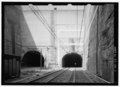 | 5,272 × 3,851 (19.36 MB) | Fæ | GWToolset: Creating mediafile for Fæ. HABS 24 July 2014 (2301:2600) |
File usage
The following pages on the English Wikipedia use this file (pages on other projects are not listed):