
File:“Brooklyn Jockey Club” (race course, club house, stables and betting pavilion) - NYPL1519739 (cropped).tiff

Size of this JPG preview of this TIF file: 474 × 600 pixels. Other resolutions: 190 × 240 pixels | 379 × 480 pixels | 607 × 768 pixels | 809 × 1,024 pixels | 1,786 × 2,260 pixels.
Original file (1,786 × 2,260 pixels, file size: 12.21 MB, MIME type: image/tiff)
| This is a file from the Wikimedia Commons. Information from its description page there is shown below. Commons is a freely licensed media file repository. You can help. |
Summary
| Description | Plate23: [Bounded by Avenue P, Ocean Avenue, Avenue U, W. 6th Street, Avenue R, W. 8th Street, Avenue P and W. 11th Street.]; Atlases of New York city. / Robinson's atlas of Kings County, New York : compiled from official records ... / under the direction of E. Robinson. | |||||||||||||||||||||||
| Catalogue call number | Map Div.+++ (Brooklyn) (Robinson, E. and Co., New York. Robinson's atlas of Kings County, New York) | |||||||||||||||||||||||
| Item/Page/Plate | Plate 23 | |||||||||||||||||||||||
| Alternate title | Part of the Town of Gravesend, Kings Co., N.Y. | |||||||||||||||||||||||
| Date | ||||||||||||||||||||||||
| Source |
http://digitalgallery.nypl.org/nypldigital/dgkeysearchdetail.cfm?imageID=1519739
|
|||||||||||||||||||||||
| Author | E. --(Elisha) -- Publisher Robinson | |||||||||||||||||||||||
| Permission (Reusing this file) |
From The Lionel Pincus and Princess Firyal Map Division. http://maps.nypl.org
|
|||||||||||||||||||||||
| Other versions | ||||||||||||||||||||||||
| Source description | 1 atlas (32 plates) : col. maps ; 56 cm. | |||||||||||||||||||||||
| Location | Stephen A. Schwarzman Building / The Lionel Pincus and Princess Firyal Map Division | |||||||||||||||||||||||
| Digital item published | 6-8-2006; updated 3-25-2011 | |||||||||||||||||||||||
| Digital ID | 1519739 | |||||||||||||||||||||||


The making of this file was supported by Wikimedia UK.
To see other files made with the support of Wikimedia UK, please see the category Supported by Wikimedia UK.
|
File history
Click on a date/time to view the file as it appeared at that time.
| Date/Time | Thumbnail | Dimensions | User | Comment | |
|---|---|---|---|---|---|
| current | 07:32, 21 February 2021 | 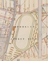 | 1,786 × 2,260 (12.21 MB) | Ooligan | File:Plate23- (Bounded by Avenue P, Ocean Avenue, Avenue U, W. 6th Street, Avenue R, W. 8th Street, Avenue P and W. 11th Street.) NYPL1519739.tiff cropped 72 % horizontally, 52 % vertically using CropTool with lossless mode. |
File usage
The following pages on the English Wikipedia use this file (pages on other projects are not listed):