
Bierawa
Bierawa | |
|---|---|
Village | |
 Road | |
 Bierawa  Bierawa | |
| Coordinates: 50°17′9″N 18°14′32″E / 50.28583°N 18.24222°E | |
| Country | |
| Voivodeship | Opole |
| County | Kędzierzyn-Koźle |
| Gmina | Bierawa |
| Population | 1,370 |
| Time zone | UTC+1 (CET) |
| • Summer (DST) | UTC+2 (CEST) |
| Vehicle registration | OK |
| Website | http://www.bierawa.pl/ |
Bierawa [bjɛˈrava] is a village in Kędzierzyn-Koźle County, Opole Voivodeship, in south-western Poland. It is the seat of the gmina (administrative district) called Gmina Bierawa.[1] It lies approximately 8 kilometres (5 mi) south-east of Kędzierzyn-Koźle and 48 km (30 mi) south-east of the regional capital Opole.
History[edit]
The name of the village probably comes from the Polish verb brać, which means "to take". In the Middle Ages it was part of Piast-ruled Poland, and afterwards it was also part of Bohemia (Czechia), Prussia and Germany. In 1936, the German administration changed the name to Reigersfeld in attempt to erase traces of Polish origin. During World War II the Germans operated two forced labour subcamps (E711, E769) of the Stalag VIII-B/344 prisoner-of-war camp in the local IG Farben factory.[2] The village became again part of Poland after the defeat of Nazi Germany in World War II in 1945, and its historic Polish name was restored.
Bierawa suffered from the 1997 Central European flood.
Transport[edit]
There is a train station, located on the Polish Railway Line No. 151 which connects Kędzierzyn-Koźle and the Polish-Czech border at Chałupki.
Gallery[edit]
-
 Holy Trinity Church
 -
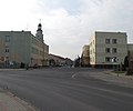 Crossroads with the primary school on the left and the post office on the right
 -
 Chapel
 -
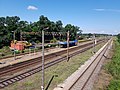 Train station
_ID_610454.jpg)


.jpg)
References[edit]
- ^ "Central Statistical Office (GUS) - TERYT (National Register of Territorial Land Apportionment Journal)" (in Polish). 2008-06-01.
- ^ "Working Parties". Lamsdorf.com. Archived from the original on 29 October 2020. Retrieved 3 April 2021.
| Seat |  | |
|---|---|---|
| Other villages | ||
This Kędzierzyn-Koźle County location article is a stub. You can help Wikipedia by expanding it. |