
Beutenaken
Beutenaken
Böätenake | |
|---|---|
Hamlet | |
.JPG) Sacred Heart chapel | |
 Beutenaken Location in the Netherlands  Beutenaken Location in the province of Limburg in the Netherlands | |
| Coordinates: 50°46′55″N 5°51′15″E / 50.781944°N 5.854167°E | |
| Country | |
| Province | |
| Municipality | |
| Area | |
| • Total | 1.55 km2 (0.60 sq mi) |
| Elevation | 130 m (430 ft) |
| Population (2021)[1] | |
| • Total | 45 |
| • Density | 29/km2 (75/sq mi) |
| Time zone | UTC+1 (CET) |
| • Summer (DST) | UTC+2 (CEST) |
| Postal code | 6278[1] |
| Dialing code | 043 |
Beutenaken (Limburgish: Böätenake) is a hamlet in the southeastern Netherlands. It is part of the village of Slenaken in the municipality of Gulpen-Wittem, Limburg, about 20 km east of Maastricht. Older names for the village are Bottinachs, Butenacho and Butenachen.
The village is built as a linear settlement in the valley of the Gulp river, on a road connecting Waterop with Slenaken. The village has a chapel dedicated to Maria dating from 1880 and a chapel dedicated to the Sacred heart dating from 1929. Also it has several timber framing buildings, including a farm located at Beutenaken 38, which dates from the 18th century and has been designated a national monument.[3]
Gallery[edit]
-
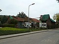 Beutenaken 38, monumental farm
 -
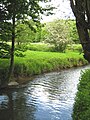 River Gulp in Beutenaken
 -
 Crossing of the river Gulp
 -
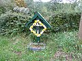 Road cross
.JPG)


References[edit]
- ^ a b c "Kerncijfers wijken en buurten 2021". Central Bureau of Statistics. Retrieved 24 April 2022.
- ^ "Postcodetool for 6278NA". Actueel Hoogtebestand Nederland (in Dutch). Het Waterschapshuis. Retrieved 24 April 2022.
- ^ Beutenaken 38 Archived 2014-05-04 at the Wayback Machine on the Dutch monument register
External links[edit]
- Beutenaken on Plaats.nl
 Media related to Beutenaken at Wikimedia Commons