Beit Rimon
Beit Rimon
בית רימון | |
|---|---|
 | |
| Coordinates: 32°46′55″N 35°19′47″E / 32.78194°N 35.32972°E | |
| Country | |
| District | Northern |
| Council | Lower Galilee |
| Affiliation | Religious Kibbutz Movement |
| Founded | 1977 |
| Founded by | Nahal |
| Population (2022) | 982[1] |
| Website | www.bet-rimon.co.il |
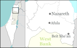
Beit Rimon (Hebrew: בֵּית רִמּוֹן, lit. House of the Pomegranate) is a kibbutz located in the Lower Galilee Regional Council in Israel. It consists of a core kibbutz and a residential expansion. It is located in the Lower Galilee on a ridge of Mount Tur'an at a height of 400 meters above sea level. As of 2022 it had a population of 982.[1]
Etymology[edit]
It is named after the Biblical Rimon (pomegranate in Hebrew) in the lands of the Tribe of Zebulun (Joshua 19:13), which "is identified with er-Rumane" at today's Arab village of Rumana, 2 km to the west.[2]
History[edit]
Beit Rimon was first settled in 1977 as a Nahal settlement. In 1979, a group of British immigrants joined the Nahal group and established a kibbutz at the site, affiliated with the Religious Kibbutz Movement.[3]
The kibbutz operates one of the largest dairy farms in the country, a chicken coop and a factory for agricultural and gardening tools. It also cultivates olives and field crops.[4]
References[edit]
- ^ a b "Regional Statistics". Israel Central Bureau of Statistics. Retrieved 21 March 2024.
- ^ Negev, Avraham; Gibson, Shimon (2001). Archaeological Encyclopedia of the Holy Land (3rd, revised, illustrated ed.). London: Continuum Publishing. p. 436. ISBN 9780826413161.
- ^ Nefesh B'Nefesh, Beit Rimon
- ^ Nefesh B'Nefesh, Beit Rimon


