
Beegden
Beegden
Bieëgdje | |
|---|---|
Village | |
 Nederhoven estate | |
 Beegden Location in the Netherlands  Beegden Location in the province of Limburg in the Netherlands | |
| Coordinates: 51°11′N 5°55′E / 51.183°N 5.917°E | |
| Country | Netherlands |
| Province | Limburg |
| Municipality | Maasgouw |
| Area | |
| • Total | 8.14 km2 (3.14 sq mi) |
| Elevation | 27 m (89 ft) |
| Population (2021)[1] | |
| • Total | 1,815 |
| • Density | 220/km2 (580/sq mi) |
| Time zone | UTC+1 (CET) |
| • Summer (DST) | UTC+2 (CEST) |
| Postal code | 6099[1] |
| Dialing code | 0475 |
| Major roads | N273 |
Beegden (Dutch pronunciation: [ˈbeːɣdə(n)]; Limburgish: Bieëgdje [ˈbiəɣdʒə]) is a village in the Dutch province of Limburg. It is a part of the municipality of Maasgouw, and is located about 6 km west of Roermond.
Until 1991, Beegden was a separate municipality. During that year the village became part of the municipality of Heel en Panheel. In 2007 the municipality of Heel en Panheel, including Beegden, became part of the new municipality of Maasgouw. The town currently has about 1800 inhabitants. During the past few years tourism has developed in Beegden, the key attractions of the town are the church, the seventeenth-century house Huis Nederhoven and the St. Lindert windmill. The last underwent a major restoration in 2000 and can be visited free of charge every Wednesday and Saturday.
Born in Beegden[edit]
- Annemiek Derckx (born 1954), Dutch canoer who twice won a bronze medal at the Summer Olympics
Gallery[edit]
-
 The Church of Beegden
 -
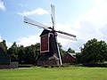 Windmill St Lindert
 -
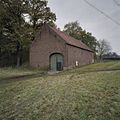 Barn in Beegden
 -
 Court of a farm house


References[edit]
- ^ a b c "Kerncijfers wijken en buurten 2021". Central Bureau of Statistics. Retrieved 25 April 2022.
- ^ "Postcodetool for 6099AA". Actueel Hoogtebestand Nederland (in Dutch). Het Waterschapshuis. Retrieved 25 April 2022.
This Dutch Limburg location article is a stub. You can help Wikipedia by expanding it. |