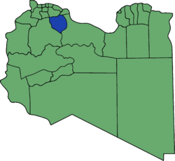
Bani Walid District

Bani Walid or Ben Walid, prior to 2007, was one of the districts of Libya, administrative town Bani Walid. In the 2007 administrative reorganization the territory formerly in Bani Walid District was transferred to Misrata District.[1]
Bani Walid bordered the following districts:
- Tarhuna wa Msalata - north
- Misrata - northeast
- Sirte - east
- Mizda - west
- Gharyan - northwest, at a quadripoint
Notes[edit]
- ^ "شعبيات الجماهيرية العظمى" – "Sha'biyat of Great Jamahiriya" Archived December 20, 2008, at the Wayback Machine, Website of the General People's Committee of Libya, accessed 5 September 2009, in Arabic
See also[edit]
External links[edit]
- Bani Walid museum Archived 2013-07-19 at the Wayback Machine
