Acequia, Colorado
Acequia, Colorado | |
|---|---|
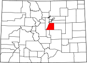
Location in Douglas County and the state of Colorado | |
| Coordinates: 39°31′25″N 105°01′41″W / 39.52361°N 105.02806°W | |
| Country | |
| State | |
| County | Douglas County[1] |
| Elevation | 5,558 ft (1,694 m) |
| Time zone | UTC-7 (MST) |
| • Summer (DST) | UTC-6 (MDT) |
| GNIS feature ID | 0182621 |
Acequia is an unincorporated community located in Douglas County, Colorado, United States.[1]
History[edit]
A post office was in operation at Acequia between 1874 and 1900.[2] Acequia is a Spanish word meaning "canal" or "channel",[3] so the name was likely in reference to the nearby High Line Canal.
Geography[edit]
Acequia is located at 39°31′25″N 105°01′41″W / 39.52361°N 105.02806°W (39.5235994,-105.0280398).[1]
References[edit]
- ^ a b c d U.S. Geological Survey Geographic Names Information System: Acequia, Colorado
- ^ "Place Names of Colorado" (PDF). Colorado Council of Genealogical Societies. 1999. p. 2. Archived from the original (PDF) on October 27, 2017. Retrieved July 1, 2019.
- ^ Gannett, Henry (1905). The Origin of Certain Place Names in the United States. p. 23.


