
Wum
Wum | |
|---|---|
Commune and town | |
 Wum Location in Cameroon | |
| Coordinates: 6°23′N 10°04′E / 6.383°N 10.067°E | |
| Country | Claimed by |
| Province | Northwest Province |
| Elevation | 1,109 m (3,638 ft) |
| Population (2012) | |
| • Total | 26,123 |
| Time zone | UTC+1 (WAT) |
Wum is a town and commune in Cameroon. It is the capital of Menchum division in the Northwest Province.


Geography[edit]
Wum is the third biggest town in the north west region of Cameroon. It lies on a plateau at an elevation of about 1100 m near the edge of the western highlands of Cameroon. It is 80 kilometres (50 mi) north of the regional capital Bamenda (by dirt road). It lies near Lake Wum, one of five small crater lakes within 15 km of the town in the hilly, volcanic landscape. Lake Nyos, a crater lake from which a limnic eruption killed nearly 2,000 people in 1986, is 25 km to the east.
Population and language[edit]
In 2012 Wum's estimated population was 80,123 inhabitants.[1]
The Aghem language, spoken in Wum, is also called Wum.[2]

Culture[edit]

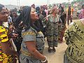
- Traditional clothing
-

-

-

-

-

-

-
-

-


References[edit]
- ^ [1] Archived October 1, 2007, at the Wayback Machine
- ^ "Linguist List - Description of Aghem". Archived from the original on 2012-07-20. Retrieved 2010-12-04.
External links[edit]
- Charles Nanga, La réforme de l’administration territoriale au Cameroun à la lumière de la loi constitutionnelle n° 96/06 du 18 janvier 1996, Mémoire ENA. (in French)
- Contrôle de gestion et performance des services publics communaux des villes camerounaises - Thèse de Donation Avele, Université Montesquieu Bordeaux IV (in French)
- Site de la primature - Élections municipales 2002 (in French)
6°23′N 10°04′E / 6.383°N 10.067°E
This Cameroon location article is a stub. You can help Wikipedia by expanding it. |