
Veen, Netherlands
Veen | |
|---|---|
Village | |
.JPG) Centre of Veen with the Netherlands Reformed Church. | |
_wapen.svg) Coat of arms | |
 Veen Location in the province of North Brabant in the Netherlands  Veen Veen (Netherlands) | |
| Coordinates: 51°46′37″N 5°6′35″E / 51.77694°N 5.10972°E | |
| Country | Netherlands |
| Province | North Brabant |
| Municipality | Altena |
| Area | |
| • Total | 3.48 km2 (1.34 sq mi) |
| Elevation | 1.5 m (4.9 ft) |
| Population (2021)[1] | |
| • Total | 2,980 |
| • Density | 860/km2 (2,200/sq mi) |
| Time zone | UTC+1 (CET) |
| • Summer (DST) | UTC+2 (CEST) |
| Postal code | 4264[1] |
| Dialing code | 0416 |
Veen is a village in the Dutch province of North Brabant. It is located in the municipality of Altena, about 20 km northwest of 's-Hertogenbosch. It is infamous for its New Year's Eve tradition during which scrap cars are burnt,[3] and in 2020 even firemen were attacked with fireworks.
History[edit]
It was first mentioned between 1108 and 1121 as de Ueno and means raised bog.[4] Veen is a river bank settlement along the Afgedamde Maas which developed in the Middle Ages.[5]
Dutch Reformed church dates from around 1200. The tower was added in the late-13th century. The church was destroyed in 1504 during the Guelders Wars, and later rebuilt. The church was enlarged in 1648. During the restoration of 1961 to 1963, it was returned to its medieval shape.[5][6]
The grist mill De Hoop was built in 1838. In 1956, it was sold to the municipality who later transferred it to a foundation who restored the mill in 1970. In 1987, it was restored and elevated, because it was hit by trucks several times due to its proximity to the road. Since 2012, it is grinding professionally again.[7]
Veen was home to 871 people in 1840.[6] In 1880, the dike breached and most of the village was destroyed. It was later rebuilt.[5]
Veen was a separate municipality until 1973, when it became part of Aalburg.[8]
Gallery[edit]
-
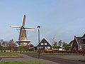 Windmill de Hoop in Veen
 -
 Veen, seen from Aalst

.JPG)
References[edit]
- ^ a b c "Kerncijfers wijken en buurten 2021". Central Bureau of Statistics. Retrieved 15 April 2022.
- ^ "Postcodetool for 4264AE". Actueel Hoogtebestand Nederland (in Dutch). Het Waterschapshuis. Retrieved 15 April 2022.
- ^ Jo Blason (2 January 2022). "Bridge diving and a Nepalese festival: the weekend's best photos". The Guardian. Retrieved 2 January 2022.
- ^ "Veen - (geografische naam)". Etymologiebank (in Dutch). Retrieved 15 April 2022.
- ^ a b c Chris Kolman & Ronald Stenvert (1997). Veen (in Dutch). Zwolle: Waanders. ISBN 90 400 9945 6. Retrieved 15 April 2022.
- ^ a b "Veen". Plaatsengids (in Dutch). Retrieved 15 April 2022.
- ^ "De Hoop". Molen database (in Dutch). Retrieved 15 April 2022.
- ^ Ad van der Meer and Onno Boonstra, Repertorium van Nederlandse gemeenten, KNAW, 2011.