
Sint-Laureins
Sint-Laureins | |
|---|---|
 Sint-Laureins town hall | |
 Flag  Coat of arms | |
Location of Sint-Laureins  | |
 Sint-Laureins Location in Belgium
Location of Sint-Laureins in East Flanders  | |
| Coordinates: 51°15′N 03°31′E / 51.250°N 3.517°E | |
| Country | |
| Community | Flemish Community |
| Region | Flemish Region |
| Province | East Flanders |
| Arrondissement | Eeklo |
| Government | |
| • Mayor | Franki Van de Moere (Samen Anders) |
| • Governing party/ies | Samen Anders |
| Area | |
| • Total | 74.54 km2 (28.78 sq mi) |
| Population (2018-01-01)[1] | |
| • Total | 6,684 |
| • Density | 90/km2 (230/sq mi) |
| Postal codes | 9980-9982, 9988 |
| NIS code | 43014 |
| Area codes | 09 |
| Website | www.sint-laureins.be |
Sint-Laureins (Dutch pronunciation: [sɪnt lʌu̯ˈrɛi̯ns]; Dutch for Saint Lawrence) is a municipality located in the Flemish province of East Flanders, in Belgium. The municipality comprises the towns of Sint-Jan-in-Eremo, Sint-Laureins proper, Sint-Margriete, Waterland-Oudeman and Watervliet. In 2021, Sint-Laureins had a total population of 6,919. The total area is 74.50 km2.[2]
The Our Lady-Church in Watervliet, built in the 16th century, is called the 'Cathedral of the North'.[3]
Gallery[edit]
-
 The Boerekreek is one of several lakes in Sint-Laureins
 -
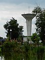 Water tower in Sint-Jan-in-Eremo
 -
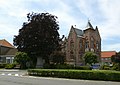 Townhall and freedom tree
 -
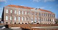 Godshuis. Nowadays hotel/restaurant

.jpg)


References[edit]
- ^ "Wettelijke Bevolking per gemeente op 1 januari 2018". Statbel. Retrieved 9 March 2019.
- ^ "Bevolking per statistische sector - Sector 43014". Statistics Belgium. Retrieved 7 May 2022.
- ^ "Sint-Laureins in vogelvlucht – Watervliet". Zwinstreek (in Dutch). Retrieved 8 May 2022.
External links[edit]
 Media related to Sint-Laureins at Wikimedia Commons
- Official website (in Dutch)
- Official website of the youth council (in Dutch)
| Aalst |  | |
|---|---|---|
| Dendermonde | ||
| Eeklo | ||
| Ghent | ||
| Oudenaarde | ||
| Sint-Niklaas | ||
| ||
| International | |
|---|---|
| National | |
| Geographic | |
This East Flanders location article is a stub. You can help Wikipedia by expanding it. |