
Showa Memorial Park
This article may rely excessively on sources too closely associated with the subject, potentially preventing the article from being verifiable and neutral. (September 2015) |
| Showa Memorial Park | |
|---|---|
 A view of the park | |
 | |
| Location | Akishima and Tachikawa, Tokyo, Japan |
| Coordinates | 35°42′36″N 139°23′42″E / 35.710°N 139.395°E |
| Area | 165.3 ha (408 acres) |
| Created | 26 October 1983 |
| Public transit access | Nishi-Tachikawa Station |
Showa Commemorative National Government Park (国営昭和記念公園, Kokuei Shōwa Kinen Kōen) is a national government park in Akishima and Tachikawa, Tokyo, Japan. It is the largest park in Tokyo, covering 165.3 ha (408 acres).
Formerly a Japanese military airbase and in the postwar era operated by the US military, Tachikawa Airfield was returned to the Japanese government in 1977. Part of the airfield remains a Japan Ground Self Defense Force base, while the remainder of the airfield was used to establish Showa Commemorative Park in 1983 as part of a project to commemorate the emperor's Golden Jubilee.[1] There is a small museum dedicated to the Showa emperor.[2]
Bicycles may be rented in the park, which has an 11 kilometer bike trail with parking areas at all locations. There is also an outdoor barbecue area.
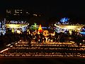
In December, the park has illuminations including Christmas lighting.
The park can be best accessed from Nishi-Tachikawa Station on the JR Ome line or via a 15- to 20-minute walk from JR's Tachikawa Station or Seibu's Musashi-Sunagawa Station.
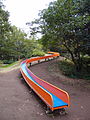
Gallery[edit]
-

-
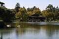 Japanese garden
 -
 Satellite view in 1989
 -

-

-

-
-

-


.jpg)


.jpg)
.jpg)

References[edit]
- ^ Showa Memorial Park webpage Details | Profile Retrieved on December 4, 2014
- ^ Showa Memorial Park webpage A zone | Area Guide Retrieved on December 4, 2014
External links[edit]
- Official site (in English)
This Tokyo location article is a stub. You can help Wikipedia by expanding it. |