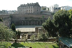
Rue Saint-Malo


Rue Saint-Malo is a paved street in Brest, France. It is located in the Carpon valley, against the plateau des Capucins in the Recouvrance quarter. Only its lower half survives, as the oldest street in the city.
It runs along the wall of the terrain de la Madeleine, where once stood the convent which took in 'sinful women' and (after the revocation of the edict of Nantes) Huguenots. It is lined with 17th- and 18th-century houses and overlooked by terraced gardens. After its fountain, the road runs into the levée de Pontaniou and ends in the staircase of the Madeleine which leads to the plateau des Capucins.
History[edit]
This section is empty. You can help by adding to it. (July 2010) |
See also[edit]
External links[edit]
- (in French) Official site for the association Vivre la rue created in 1989 for the preservation of rue Saint-Malo
