
Reykjanes
| Reykjanes volcanic system | |
|---|---|
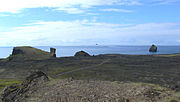
 Reykjanes with view of Reykjanesviti Lighthouse and beyond the Reykjanes Power Station to north-east | |
| Highest point | |
| Elevation | 93 m (305 ft)[1] |
| Coordinates | 63°49′12″N 22°41′24″W / 63.82000°N 22.69000°W[1] |
| Dimensions | |
| Length | 45 km (28 mi)[2] |
| Width | 5–6 km (3.1–3.7 mi)[3] |
| Area | 25 km2 (9.7 sq mi)[4] |
| Naming | |
| English translation | smoking point |
| Language of name | Icelandic |
| Geography | |
 Reykjanes volcanic system | |
| Geology | |
| Mountain type | Volcanic system |
| Last eruption | 1240 CE |
 Selected geological features near the Reykjanes volcanic system (approximate outline in red as part of system is ill defined). This is not the Reykjanes headland region which is smaller. Clicking on the image enables mouse-over with more detail where shading also shows: other fissure swarms, central volcanoes, calderas subglacial terrain above 1,100 m (3,600 ft), seismically active areas between 1995 to 2007. | |
Reykjanes (Icelandic pronunciation: [ˈreiːcaˌnɛːs]) is a small headland on the south-western end of the Reykjanes Peninsula in Iceland, giving the main peninsula its name. Volcanic action is responsible for forming the entire peninsula. The nearest town is Keflavik.
The name, Reykjanes, translates to "smoking point,” reykja 'smoking', and nes 'point'. It is named this due to the continuing volcanic activity of the Reykjanes volcanic belt; there are also many other uses of this name in Iceland, e.g. the Reykjanes Peninsula or Reykjanes in Ísafjarðardjúp.
Geography[edit]
The region is about nine kilometres (5+1⁄2 miles) to the south of Iceland's international airport.[5] It is about 25 km2 (9.7 sq mi)[4] and includes the Reykjanes volcanic system that extends in a linear fashion up its centre continuing to the north-east as the hill of Sýrfell at 93 m (305 ft) high.[1] Other volcanic systems of the Reykjanes volcanic belt could affect the Reykjanes region and have erupted as recently as 2024. Other hills associated with the system are Skálafell (Grindavíkurbær) with a height of 76 m (249 ft) in the south-west near the sea and Bæjarfell at 69 m (226 ft) high to its north.
The Reykjanesviti lighthouse is on Bæjarfell and is fairly frequently visited by tourists.[6]. The geothermal power station is inland from the lighthouse to its north-east.[7]
Valahnúkamöl is its south western cliff coast leading to Reykjanestá, the most south-western cape of the area.
Geology[edit]
The basaltic low relief lava shields of the Reykjanes volcanic system are typically more than 4500 years old, but towards the south there are more recent eruptive fissures,[8] with crater rows, tindars and hyaloclastite hills as well as parts of tuff cones near the south-west shoreline.[9] The offshore volcanoes have produced 15 different tephra layers in the region.[10] The volcano erupted for a 30 odd year period ending in 1240 CE.[11] In 1226 CE an explosive eruption off Reykjanes produced about 0.1 km3 (0.024 cu mi) of tephra with deposits up to 100 km (62 mi) away.[12] It also has lava dated to 2150 years ago and 3200 years ago.[11] The Reykjanes volcano has been classified historically with the active as of 2024 Eldvörp–Svartsengi volcano to its south-east as its rift system intersects this to the east in the Reykjanes volcanic belt[13] and the two volcanic systems are very similar, even though they have separate geothermal systems,and lava composition.[14] Recent studies tend to classify the Reykjanes volcanic system as a separate fissure volcano of the Reykjanes volcano belt.[15] This volcanic system marks the transition from the mainly extensional structure of the underwater Reykjanes Ridge of the Atlantic mid-oceanic ridge to a trans-tensional plate boundary in the Reykjanes Peninsula.[4] The 5–6 km (3.1–3.7 mi) wide Reykjanes volcanic system is in a rift zone,[3] which extends 45 km (28 mi), [2] including at least 9 km (5.6 mi) out to sea towards the Reykjanes Ridge.[16][2] Volcanic rock production has kept pace with rift extension and subsidence with at least ten eruptions in the 14,500 years since the area became ice free after the end of the last ice age.[3] Within the volcanic system there are active NE–SW dip-slip faults.[17] There are two main fissure swarm zones being in the north (Stampar) and south (Sýrfell). They are separated by about 2 km (1.2 mi), and their western parts have been active in the last three eruptive periods of the Reykjanes area.[18] [10]
The volcanic rocks are basalts, with picrite, or tholeiite characteristics.[14] While the active volcanism on the peninsula has been a major source for the geothermal activity in the area, there is evidence that the volcanism can fuel geothermal systems up to 30 kilometers away, as far as Hvalfjörður.[19] On the Reykjanes Peninsula itself, the system has had its geothermal potential exploited, producing up to 176 MW of energy.[3]
Most of the Reykjanes area is at risk of disruption from future eruptions and susceptibility maps have been published.[20]
See also[edit]
- Reykjanes' scenery
-
 Valahnúkamöl coast to south towards Reykjanestá
 -
 Reykjanesviti lighthouse on Bæjarfell with lighthouse keeper's residence
 -
 Reykjanesviti lighthouse with steam from the geothermal area of Gunnuhver
 -
 Suðurnesjavirkjun (Reykjanes Power Station) with cooling ponds
 -
 View from Reykjanestá to south-west with Eldey in the far background
 -
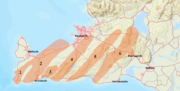 Map of volcanic systems on the Reykjanes Peninsula. The Reykjanes system is marked here as number 1
.jpg)

.jpg)
.jpg)


References[edit]
- ^ a b c "National Land Survey of Iceland : Sýrfell". Landmælingar Íslands. 28 December 2023.
- ^ a b c Sæmundsson, Sigurgeirsson & Friðleifsson 2020, The Reykjanes volcanic system.
- ^ a b c d Sæmundsson, Sigurgeirsson & Friðleifsson 2020, Abstract.
- ^ a b c Sæmundsson, Sigurgeirsson & Friðleifsson 2020, Introduction.
- ^ "Reykjanes". Global Volcanism Program. Retrieved 6 August 2023.
- ^ Andrésdóttir 2018, pp. 54–55.
- ^ Andrésdóttir 2018, pp. 57.
- ^ Andrésdóttir 2018, p. 28.
- ^ Sigurgeirsson & Einarsson 2019, 2. Morphology and topography.
- ^ a b Sigurgeirsson & Einarsson 2019, 4. Eruption history and pattern.
- ^ a b Andrésdóttir 2018, p. 32.
- ^ Sigurgeirsson & Einarsson 2019, 11. Largest known eruption.
- ^ Andrésdóttir 2018, p. 30.
- ^ a b Sigurgeirsson & Einarsson 2019, 1. Geological setting and tectonic context.
- ^ Sæmundsson, Sigurgeirsson & Friðleifsson 2020, Conclusions.
- ^ Sigurgeirsson & Einarsson 2019, Short Description.
- ^ Sæmundsson, Sigurgeirsson & Friðleifsson 2020, Faulting.
- ^ Andrésdóttir 2018, p. 48.
- ^ Bergerat, Françoise; Sæmundsson, Kristjan; Fourel, Loïc; Angelier, Jacques (2013-07-01). "Structure and activity of the geothermal field of Hvalfjörður (Iceland) from brittle tectonic, geothermal and paleostress analysis". Bulletin de la Société Géologique de France. 184 (4–5): 451–465. doi:10.2113/gssgfbull.184.4-5.451. ISSN 1777-5817.
- ^ Andrésdóttir 2018, pp. 69–73.
Sources[edit]
- Sæmundsson, K.; Sigurgeirsson, M.Á.; Friðleifsson, G.Ó. (2020). "Geology and structure of the Reykjanes volcanic system, Iceland". Journal of Volcanology and Geothermal Research. 391 (106501). doi:10.1016/j.jvolgeores.2018.11.022.
- Andrésdóttir, Þóra Björg (2018). Volcanic hazard and risk assessment at Reykjanes, vulnerability of infrastructure. Masters thesis (PDF) (Thesis). University of Iceland. pp. 1–89. Retrieved 28 December 2023.
- Sigurgeirsson, Magnús Á.; Einarsson, Sigmundur (2019). "Catalogue of Icelandic Volcanoes - Reykjanes and Svartsengi volcanic systems". Icelandic Meteorological Office, Institute of Earth Sciences at the University of Iceland, Civil Protection Department of the National Commissioner of the Iceland Police. Retrieved 29 December 2023.