
Idrottsparken (Sundsvall)
Sundsvalls Idrottspark | |
.jpg) | |
 | |
| Former names | Sundsvall Park Arena (during concerts 2002-2006) Norrporten Arena (2006–2016) Idrottsparken (2016-2018)[2] |
|---|---|
| Address | Universitetsallén 6, 852 34 Sundsvall |
| Location | Sundsvall, Sweden |
| Owner | Sundsvall Municipality |
| Capacity | 8,000, of which 5,000 are seated under roof[2] |
| Record attendance | (Football) 16,507 (GIF Sundsvall vs Högadals IS), 1961 Allsvenskan play-off[1] |
| Field size | 105 m x 68 m |
| Surface | Artificial turf |
| Construction | |
| Opened | 6 August 1903 |
| Renovated | 2001–2002 |
| Construction cost | 150 million SEK |
| Tenants | |
| GIF Sundsvall (1903–present) Sundsvalls DFF (1984–present) | |
Idrottsparken (or Sundsvalls Idrottspark) is a multi-purpose stadium in Sundsvall, Sweden. It was opened on 6 August 1903.[3] It is currently used mostly for football matches and is the home stadium of GIF Sundsvall and Sundsvalls DFF. The stadium holds 8,000 people during football matches.
The stadium was expanded in 2002 and was also called Sundsvall Park Arena during concerts 2002 – 2006.
History[edit]
The venue was inaugurated in 1903, the same year as GIF Sundsvall and had tracks for running, skittles, shooting and tennis. Idrottsparken undergone a major renovation in the early 2000s and was re-inaugared by Carl XVI Gustaf on ninth of June 2002. The football pitch had grass as turf until 2004 when it switched to artificial turf, mainly because of poor quality of the grass turf due to cold climate.[2]
Overview[edit]
.jpg)
Gallery[edit]
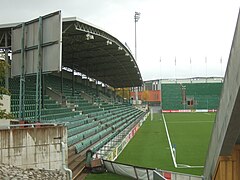
-
 Arena viewed from the north.
 -
 Idrottsparken in 2008.
 -
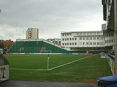
 North stand.
 -
 East stand.
 -
 Snowstorm in November 2010.
 -
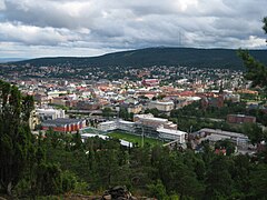 The arena and city of Sundsvall, 2010.


See also[edit]
References[edit]
- ^ "GIF Sundsvall - Fakta" (in Swedish). GIF Sundsvall. Retrieved 9 January 2022.
- ^ a b c "NP3 Arena" (in Swedish). Archived from the original on 2021-05-09. Retrieved 2021-10-26.
- ^ "Norrporten Arena" (in Swedish). Sundsvall Municipality. Archived from the original on 14 December 2012. Retrieved 15 October 2011.
External links[edit]
 Media related to Norrporten Arena at Wikimedia Commons
- NP3 Arena at gifsundsvall.se
| Authority control databases: Geographic |
|---|