
Netterden
Netterden | |
|---|---|
 Walburgisplein 4 | |
 Coat of arms | |
 Netterden Location in the Netherlands  Netterden Netterden (Netherlands) | |
| Coordinates: 51°51′16″N 6°18′51″E / 51.85444°N 6.31417°E | |
| Country | Netherlands |
| Province | Gelderland |
| Municipality | Oude IJsselstreek |
| Area | |
| • Total | 9.45 km2 (3.65 sq mi) |
| Elevation | 15 m (49 ft) |
| Population (2021)[1] | |
| • Total | 575 |
| • Density | 61/km2 (160/sq mi) |
| Time zone | UTC+1 (CET) |
| • Summer (DST) | UTC+2 (CEST) |
| Postal code | 7077[1] |
| Dialing code | 0315 |
| Website | netterden.nl |
Netterden is a village in the Dutch province of Gelderland. It is located in the municipality of Oude IJsselstreek, about 5 km northeast of Emmerich am Rhein in Germany.
Netterden was a separate municipality until 1821, when it was merged with Bergh.[3] The village has a border crossing to Emmerich am Rhein. The Netterdenscher Kanal is the border canal separating both countries.
History[edit]
It was first mentioned in 1218 as Netterthen. The etymology is unclear. The village of Nütterden is just across the border.[4] In 1840, it was home to 350 people.[5] In 2011, a little Lady chapel appeared in Netterden. It is unclear who made and placed it there.[6]
Gallery[edit]
-
 Church: de Sint Walburgiskerk
 -
 Walburgisplein 3
 -
 St. Walburgis
 -
 Emmerikseweg 2
 -
 Emmerikseweg 4
 -
 Netterdenscher Kanal
 -
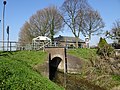 Border canal


References[edit]
- ^ a b c "Kerncijfers wijken en buurten 2021". Central Bureau of Statistics. Retrieved 24 March 2022.
two entries
- ^ "Postcodetool for 7077AA". Actueel Hoogtebestand Nederland (in Dutch). Het Waterschapshuis. Retrieved 24 March 2022.
- ^ Ad van der Meer and Onno Boonstra, Repertorium van Nederlandse gemeenten, KNAW, 2011.
- ^ "Netterden - (geografische naam)". Etymologiebank (in Dutch). Retrieved 24 March 2022.
- ^ "Netterden". Plaatsengids (in Dutch). Retrieved 24 March 2022.
- ^ "Raadsels rond kapelletje in Netterden". Gelderlander (in Dutch). 6 May 2011. Retrieved 24 March 2022.