
Meiko Nishi Ohashi roadway bridges
Meiko Nishi Ohashi roadway bridges | |
|---|---|
 | |
| Coordinates | 35°03′07″N 136°50′04″E / 35.051843°N 136.834545°E |
| Crosses | port of Nagoya |
| Locale | Nagoya |
| Characteristics | |
| Design | semi-fan cable-stayed bridges with continuous steel-box girder decks and A-frame pylons[1] |
| Material | Steel |
| Total length | approximately 758 metres (2,487 ft) (both) |
| Height | 122 metres (400 ft) (pylons) |
| Longest span | 406 metres (1,332 ft) (1985 bridge)[2] 405 metres (1,329 ft) (1997 bridge)[3] |
| No. of spans | 3 each |
| Piers in water | 2 each |
| History | |
| Opened | 1985 (1st) 1997 (2nd) |
| Location | |
 | |
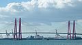
The Meiko Nishi Ohashi roadway bridges (名港西大橋) are two cable-stayed bridges, completed in 1985 and 1997, crossing the port of Nagoya in Japan. Their pylons are A-shaped and painted bright red.
-
 Meiko Nishi Bridges from a distance
 -
 Under the bridges
 -
 Driving on the bridges
 -
 Ship crossing under the bridges


References[edit]
- ^ American Society of Civil Engineers (2007). Bridges 2008. ASCE. pp. June bridge. ISBN 978-0-7844-0945-9.
- ^ Meiko Nishi Bridge at Structurae
- ^ Second Meiko Nishi Bridge at Structurae
This article about a bridge in Japan is a stub. You can help Wikipedia by expanding it. |