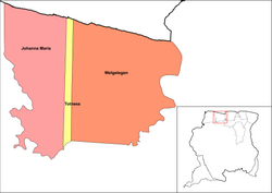
Johanna Maria
Johanna Maria | |
|---|---|
 Houses in Burnside | |
 Map showing the resorts of Coronie District. Johanna Maria | |
| Country | |
| District | Coronie District |
| Area | |
| • Total | 1,586 km2 (612 sq mi) |
| Population (2012)[1] | |
| • Total | 648 |
| • Density | 0.41/km2 (1.1/sq mi) |
| Time zone | UTC-3 (AST) |
Johanna Maria is a town and resort in Suriname, located in the Coronie District. Its population at the 2012 census was 648.[1] The town is named the cotton plantation Johanna Maria founded in 1801[2] which was owned by Johanna Maria Christina van Onna from 1863 onwards.[3] The coast line subject to flooding and erosion caused by the degradation of the mangrove forests. Plans have been drawn up to construct a 12 kilometre long dike near the coast.[4]
Johanna Maria has a school, and clinic, but the area from Clyde to Burnside has no electricity, or telephone.[4] In 1970 the Krioro Masanga was built in Johanna Maria, a multi purpose information and recreation building with a theatre and a library.[5]
References[edit]
- ^ a b "2012 Census Resorts Suriname" (PDF). Spang Staging. Retrieved 11 May 2020.
- ^ "Coronie Webportal - Johanna Maria" (in Dutch). Retrieved 25 May 2020.
- ^ "Plantage Johanna Maria". Suriname Plantages. Retrieved 25 May 2020.
- ^ a b "Structuur Analyse" (PDF). Planning Office Suriname (in Dutch). Retrieved 25 May 2020.
- ^ "Een geschiedenis van de Surinaamse literatuur. Deel 4". Digital Library for Dutch Literature (in Dutch). 2002. Retrieved 25 May 2020.

