
Fosses-la-Ville
Fosses-la-Ville
Fosse-li-Veye (Walloon) | |
|---|---|
 Town square and town hall | |
 Flag  Coat of arms | |
Location of Fosses-la-Ville  | |
 Fosses-la-Ville Location in Belgium
Location of Fosses-la-Ville in Namur Province  | |
| Coordinates: 50°24′N 04°42′E / 50.400°N 4.700°E | |
| Country | |
| Community | French Community |
| Region | Wallonia |
| Province | Namur |
| Arrondissement | Namur |
| Government | |
| • Mayor | Gaëtan De Bilderling (UD) |
| • Governing party/ies | Union Démocratique (UD) |
| Area | |
| • Total | 63.31 km2 (24.44 sq mi) |
| Population (2018-01-01)[1] | |
| • Total | 10,449 |
| • Density | 170/km2 (430/sq mi) |
| Postal codes | 5070 |
| NIS code | 92048 |
| Area codes | 071 |
| Website | www.fosses-la-ville.be |
Fosses-la-Ville (French pronunciation: [fos la vil] ⓘ; Walloon: Fosse-li-Veye) is a city and municipality of Wallonia located in the province of Namur, Belgium.
On January 1, 2018, Fosses-la-Ville had a total population of 10,449. The total area is 63.24 km2 which gives a population density of 165 inhabitants per km2.
The municipality consists of the following districts: Aisemont, Fosses, Le Roux, Sart-Eustache, Sart-Saint-Laurent, and Vitrival.
Main sights[edit]
- Collegiate church of Saint-Feuillen, rebuilt in the 18th century. It has maintained a Romanesque tower from the 10th century.
- Chapelle Sainte-Brigide, a small sanctuary built by Irish monks, dedicated to Brigid of Kildare
Twin towns[edit]
 Orbey, France
 Robecco sul Naviglio, Italy
Gallery[edit]
-
 Brigit of Kildare's chapel in Fosses-la-Ville
 -
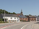
 Route N922, entry of the town Fosses-la-ville
 -
 Church ( l'église Saint Pierre) in the street of Vitrival
 -
 War memorial in Le Roux


References[edit]
- ^ "Wettelijke Bevolking per gemeente op 1 januari 2018". Statbel. Retrieved 9 March 2019.
External links[edit]
 Media related to Fosses-la-Ville at Wikimedia Commons
- Official website
Places adjacent to Fosses-la-Ville | ||||||||||||||||
|---|---|---|---|---|---|---|---|---|---|---|---|---|---|---|---|---|
| ||||||||||||||||
Municipalities in the province of Namur, Wallonia | ||
|---|---|---|
| Dinant |  | |
| Namur | ||
| Philippeville | ||
Bold indicates cities | ||
| International | |
|---|---|
| National | |
| Geographic | |
This Namur Province location article is a stub. You can help Wikipedia by expanding it. |