
File:Vulcano bransfield-strait hg.png

Size of this preview: 800 × 537 pixels. Other resolutions: 320 × 215 pixels | 640 × 430 pixels | 1,024 × 688 pixels | 1,280 × 860 pixels | 2,560 × 1,720 pixels | 3,132 × 2,104 pixels.
Original file (3,132 × 2,104 pixels, file size: 934 KB, MIME type: image/png)
| This is a file from the Wikimedia Commons. Information from its description page there is shown below. Commons is a freely licensed media file repository. You can help. |
Summary
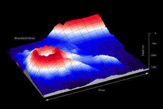
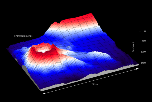
| Description | Submarine volcano in Bransfield Strait, Antarctica - mapped with a swath sonar system by the German research vessel Polarstern |
| Date | before 2007-06-24 |
| Source | Own work |
| Author | Hannes Grobe/AWI |
Licensing
This file is licensed under the Creative Commons Attribution 3.0 Unported license.
- You are free:
- to share – to copy, distribute and transmit the work
- to remix – to adapt the work
- Under the following conditions:
- attribution – You must give appropriate credit, provide a link to the license, and indicate if changes were made. You may do so in any reasonable manner, but not in any way that suggests the licensor endorses you or your use.
File history
Click on a date/time to view the file as it appeared at that time.
| Date/Time | Thumbnail | Dimensions | User | Comment | |
|---|---|---|---|---|---|
| current | 21:59, 10 November 2013 | | 3,132 × 2,104 (934 KB) | Hgrobe | |
| 09:32, 23 June 2007 |  | 3,132 × 2,104 (934 KB) | Hgrobe | {{Information |Description=to be defined |Source=own work |Date=2007-06-20 |Author=~~~~, Alfred Wegener Institute for Polar and Marine Research, Bremerhaven, Germany |Permission=Own work, share alike, attribution required (Creative Commons CC-BY-SA-2.5) | |
File usage
The following pages on the English Wikipedia use this file (pages on other projects are not listed):
Global file usage
The following other wikis use this file:
- Usage on ar.wikipedia.org
- Usage on ast.wikipedia.org
- Usage on ca.wikipedia.org
- Usage on ceb.wikipedia.org
- Usage on de.wikipedia.org
- Usage on eo.wikipedia.org
- Usage on es.wikipedia.org
- Usage on eu.wikipedia.org
- Usage on fr.wikipedia.org
- Usage on hr.wikipedia.org
- Usage on it.wikipedia.org
- Usage on ja.wikipedia.org
- Usage on nn.wikipedia.org
- Usage on no.wikipedia.org
- Usage on pt.wikipedia.org
- Usage on sr.wikipedia.org
- Usage on sv.wikipedia.org
- Usage on tr.wikipedia.org
- Usage on uk.wikipedia.org
- Usage on www.wikidata.org