
File:Venezia location map.svg

Size of this PNG preview of this SVG file: 675 × 396 pixels. Other resolutions: 320 × 188 pixels | 640 × 375 pixels | 1,024 × 601 pixels | 1,280 × 751 pixels | 2,560 × 1,502 pixels.
Original file (SVG file, nominally 675 × 396 pixels, file size: 4.7 MB)
| This is a file from the Wikimedia Commons. Information from its description page there is shown below. Commons is a freely licensed media file repository. You can help. |
Summary
| Camera location | | View this and other nearby images on: OpenStreetMap |
|---|
| Description |
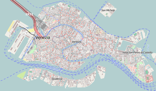
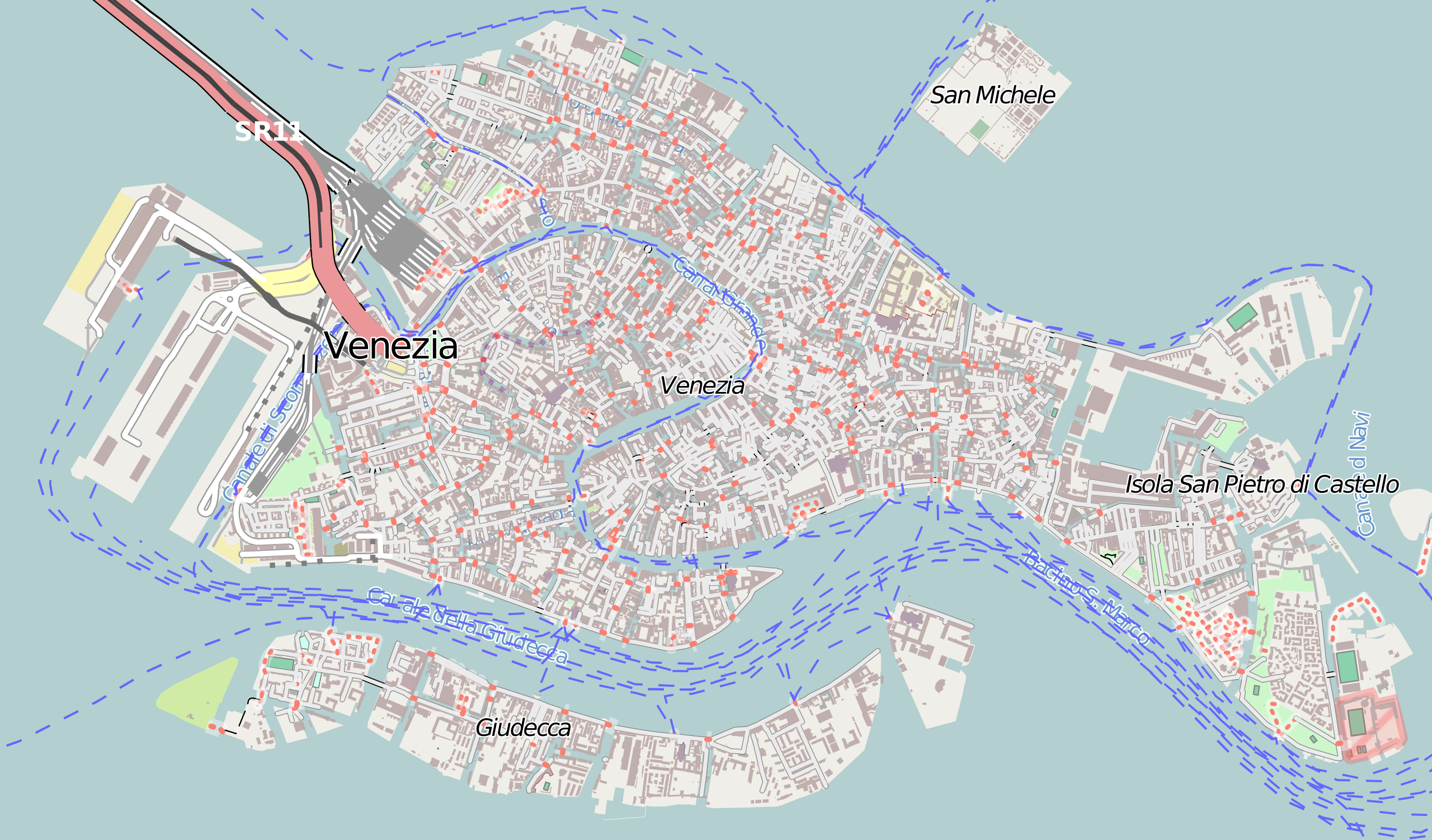
Italiano: Mappa di Venezia.
Français : Carte de Venise, destinée à la géolocalisation.
Deutsch: Karte der Venedig.
English: Map of Venice, for geolocalisation purpose.
Español: Mapa de Venecia.
日本語: ヴェネツィアの地図。
Português: Carta de Veneza.
|
||
| Date | (UTC) | ||
| Source |
Création personnelle ; Données de la carte © les contributeurs d'OpenStreetMap, CC-BY-SA Openstreetmap directement téléchargées en SVG depuis la carte d'OSM ; |
||
| Author | © Bourrichon (talk) - fr:Bourrichon | ||
| Permission (Reusing this file) |
|
This W3C-unspecified vector image was created with Inkscape .
Licensing
I, the copyright holder of this work, hereby publish it under the following license:
This file is licensed under the Creative Commons Attribution-Share Alike 2.0 France license.
Attribution: Bourrichon (atelier graphique)
- You are free:
- to share – to copy, distribute and transmit the work
- to remix – to adapt the work
- Under the following conditions:
- attribution – You must give appropriate credit, provide a link to the license, and indicate if changes were made. You may do so in any reasonable manner, but not in any way that suggests the licensor endorses you or your use.
- share alike – If you remix, transform, or build upon the material, you must distribute your contributions under the same or compatible license as the original.

File history
Click on a date/time to view the file as it appeared at that time.
| Date/Time | Thumbnail | Dimensions | User | Comment | |
|---|---|---|---|---|---|
| current | 11:20, 8 July 2013 | | 675 × 396 (4.7 MB) | Bourrichon | == {{int:filedesc}} == {{Location|45|44|00|N|12|34|00|E|scale:10000}} {{Information |Description= {{it|Mappa di it:Venezia.}} {{fr|Carte de fr:Venise, destinée à la géolocalisation.}} {{de|Karte der de:Venedig.}} {{en|Map of [[:... |
File usage
The following pages on the English Wikipedia use this file (pages on other projects are not listed):
- Abbazia della Misericordia
- Angelo San Raffaele, Venice
- Asplund Pavilion
- Carmini
- Gesuati
- Great German Synagogue
- Italian Synagogue (Venice)
- La Maddalena, Venice
- Le Eremite
- Le Zitelle
- Madonna dell'Orto
- Ognissanti, Venice
- Palazzo da Lezze, Venice
- San Barnaba, Venice
- San Bartolomeo, Venice
- San Basso
- San Beneto
- San Biagio, Venice
- San Canciano, Venice
- San Cassiano, Venice
- San Fantin, Venice
- San Felice, Venice
- San Francesco della Vigna
- San Francesco di Paola, Venice
- San Geremia
- San Giacomo dell'Orio
- San Giacomo di Rialto
- San Giobbe
- San Giorgio dei Greci
- San Giovanni Elemosinario
- San Giovanni Evangelista, Venice
- San Giovanni Grisostomo, Venice
- San Giovanni Nuovo, Venice
- San Giovanni in Bragora
- San Gregorio, Venice
- San Lazzaro dei Mendicanti
- San Lio, Venice
- San Lorenzo, Venice
- San Luca, Venice
- San Marcuola
- San Martino, Venice
- San Marziale
- San Maurizio, Venice
- San Michele in Isola
- San Moisè, Venice
- San Nicolò dei Mendicoli
- San Pantalon
- San Polo (church)
- San Rocco, Venice
- San Salvador, Venice
- San Samuele, Venice
- San Sebastiano, Venice
- San Silvestro, Venice
- San Simeone Piccolo
- San Simeone Profeta
- San Stae
- San Tomà, Venice
- San Trovaso
- San Vidal, Venice
- San Zaccaria, Venice
- San Zan Degola
- San Zulian
- Sant'Alvise
- Sant'Andrea della Zirada
- Sant'Antonin, Venice
- Sant'Aponal
- Sant'Elena, Venice
- Sant'Eufemia, Venice
- Santa Fosca, Venice
- Santa Giustina, Venice
- Santa Margherita, Venice
- Santa Maria Formosa
- Santa Maria Mater Domini
- Santa Maria Zobenigo
- Santa Maria dei Derelitti
- Santa Maria dei Miracoli, Venice
- Santa Maria del Pianto, Venice
- Santa Maria della Fava
- Santa Maria della Pietà, Venice
- Santa Maria delle Penitenti
- Santa Sofia, Venice
- Santi Apostoli, Venice
- Santo Stefano, Venice
- Scalzi, Venice
- Tolentini, Venice
- User:RUFCVA/sandbox
- User:Stielauj/San Salvador, Venice
- Draft:San Geremia (island)
- Draft:San Giobbe (Island)
- Module:Location map/data/Italy Venice
- Module:Location map/data/Italy Venice/doc
- Module:Location map/data/Venezia
Global file usage
The following other wikis use this file:
- Usage on az.wikipedia.org
- Usage on bg.wikipedia.org
- Usage on eo.wikipedia.org
- Granda Kanalo de Venecio
- Festivalo de Venecio
- Baziliko Sankta Marko en Venecio
- Doĝo-palaco
- Ponto de la suspiroj
- Ponto Rialto
- Teatro La Fenice
- Librejo Marciana
- San Giorgio Maggiore (insulo)
- San Michele (Venecio)
- Placo de Sankta Marko
- Venecia Horloĝturo
- Ca' d'Oro
- Kampanilo de Sankta Marko
- Ospedale della Pietà
- Teatro San Angelo
- Venezia Santa Lucia (stacidomo)
- Ŝablono:Situo sur mapo Italio Venecio
- Usage on es.wikipedia.org
- Basílica de San Marcos
- Puente de los Suspiros (Venecia)
- Ca' d'Oro
- Palacio Ducal de Venecia
- Puente de Rialto
- Galería de la Academia de Venecia
- Piazzale Roma
- Plaza de San Marcos
- Puente de los Descalzos
- Puente de la Academia
- Ca' Rezzonico
- Basílica de Santa María dei Frari
- Museo Guggenheim de Venecia
- Basílica de San Giorgio Maggiore
- Iglesia del Redentor (Venecia)
- Biblioteca Marciana
- Iglesia de Santa María de los Milagros (Venecia)
- Campo San Polo
- Palacio Grassi
- Palacio Contarini del Bovolo
- Iglesia de la Madonna dell'Orto
- Iglesia de San Juan Crisóstomo (Venecia)
- San Giacomo dall’Orio
View more global usage of this file.