
File:Tikøb Kommunekontor (c. 1948).jpg

Tikøb_Kommunekontor_(c._1948).jpg (640 × 387 pixels, file size: 91 KB, MIME type: image/jpeg)
| This is a file from the Wikimedia Commons. Information from its description page there is shown below. Commons is a freely licensed media file repository. You can help. |
.jpg)
Summary
| Description |
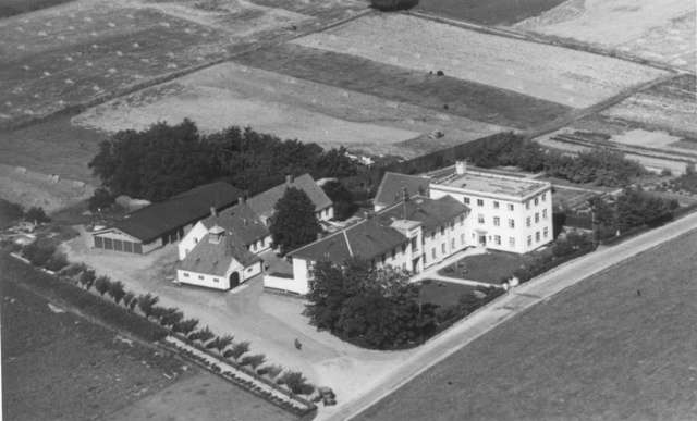
English: Rhe former Tikøb Forsøgelses- og Arbejdsanstalt ("Anstalten") and Municipal Office in Tikøb, Denmark Details: "Tikøb Kommunekontor og alderdomshjem fotograferet omkring 1948. De to bygninger parallelt med Gurrevejen var bygget i 1861 som Tikøb Fattig- og Arbejdsanstalt. Fra 1867 rummede ejendommen tillige kommunekontor. Fra 1877 også en sindsygeafdeling. Til venstre ses en mindre bygning, bygget i 1931 som Tikøb Brandstation. Den høje bygning til højre i billedet, blev bygget i 1943-44.", |
| Date | circa 1948 |
| Source | http://www.helsingorleksikon.dk/images/thumb/9/99/Kommunekontor-mm-1948.jpg/640px-Kommunekontor-mm-1948.jpg |
| Author | Ybbiwb |
| Object location | | View this and other nearby images on: OpenStreetMap |
|---|
.jpg¶ms=056.024020_N_0012.458280_E_globe:Earth_class:object_type:object__&language=en)
Licensing
| This image is in the public domain in Denmark because the Danish Consolidated Act on Copyright of 2010 specifies (§91, 5) that all photographic images not considered to be "photographic works" that were created before 1 January 1970 are exempt from protection (details).
Note that "photographic works", which must display artistic merit or originality, enter the public domain 70 years after the death of the photographer and that photographs that are not considered works but created 1 January 1970 or later become public domain 50 years after they were created. See Licensing for details. Some countries have a lower threshold of originality and may therefore apply a longer protection term for this image, so it may not be usable in such countries. To uploader: For this to be applicable, creation year must be known (or known to be at least before 1970)
|
 |
This work is in the public domain in the United States because it meets three requirements:
For background information, see the explanations on Non-U.S. copyrights.
Note: This tag should not be used for sound recordings. |
File history
Click on a date/time to view the file as it appeared at that time.
| Date/Time | Thumbnail | Dimensions | User | Comment | |
|---|---|---|---|---|---|
| current | 06:38, 18 January 2015 | | 640 × 387 (91 KB) | Ramblersen | User created page with UploadWizard |
.jpg)