
File:Tibau.png

Size of this preview: 611 × 599 pixels. Other resolutions: 245 × 240 pixels | 489 × 480 pixels | 833 × 817 pixels.
Original file (833 × 817 pixels, file size: 831 KB, MIME type: image/png)
| This is a file from the Wikimedia Commons. Information from its description page there is shown below. Commons is a freely licensed media file repository. You can help. |
Summary
| Description |
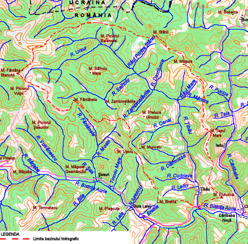
English: Map of the Ţibău River Basin |
| Date | |
| Source |
|
| Author | Afil |
| Permission (Reusing this file) |
Licensing
I, the copyright holder of this work, hereby publish it under the following license:

|
Permission is granted to copy, distribute and/or modify this document under the terms of the GNU Free Documentation License, Version 1.2 or any later version published by the Free Software Foundation; with no Invariant Sections, no Front-Cover Texts, and no Back-Cover Texts. A copy of the license is included in the section entitled GNU Free Documentation License. |
File history
Click on a date/time to view the file as it appeared at that time.
| Date/Time | Thumbnail | Dimensions | User | Comment | |
|---|---|---|---|---|---|
| current | 04:04, 26 June 2010 | | 833 × 817 (831 KB) | Afil | {{Information |Description={{en|1=Map of the Ţibău River Basin}} |Source= :A Monarchia III katonai felmerese 1900 Harta 43-48 :A Monarchia III katonai felmerese 1900 Harta 43-48 :Военно-топографичекое управление генер� |
| 20:30, 1 October 2009 |  | 833 × 817 (831 KB) | Afil | {{Information |Description={{en|1=Map of the Ţibău river basin}} |Source={{own}} |Author=Afil |Date=2009-10-1 |Permission=This image is hereby released into the public domain by its creator, Afil. This applies worldwide. |other_versions= } |
File usage
The following pages on the English Wikipedia use this file (pages on other projects are not listed):
Global file usage
The following other wikis use this file:
- Usage on ro.wikipedia.org
- Usage on uk.wikipedia.org