
File:Slamannan map.gif

Size of this preview: 800 × 426 pixels. Other resolutions: 320 × 170 pixels | 640 × 340 pixels | 1,024 × 545 pixels | 1,532 × 815 pixels.
Original file (1,532 × 815 pixels, file size: 58 KB, MIME type: image/gif)
| This is a file from the Wikimedia Commons. Information from its description page there is shown below. Commons is a freely licensed media file repository. You can help. |
Summary
| Description |
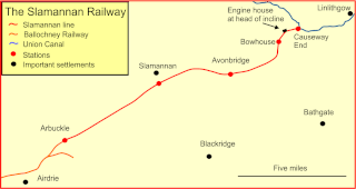
English: Map of the Slamannan Railway, Scotland |
| Date | |
| Source | Own work |
| Author | Afterbrunel |
Licensing
I, the copyright holder of this work, hereby publish it under the following license:
This file is licensed under the Creative Commons Attribution-Share Alike 3.0 Unported license.
- You are free:
- to share – to copy, distribute and transmit the work
- to remix – to adapt the work
- Under the following conditions:
- attribution – You must give appropriate credit, provide a link to the license, and indicate if changes were made. You may do so in any reasonable manner, but not in any way that suggests the licensor endorses you or your use.
- share alike – If you remix, transform, or build upon the material, you must distribute your contributions under the same or compatible license as the original.
Summary
A map of the route of the Slamannan Railway, an early railway built across the moors between Airdrie and Linlithgow in Scotland.
Prepored using Corel Draw from numerous mapping sources
File history
Click on a date/time to view the file as it appeared at that time.
| Date/Time | Thumbnail | Dimensions | User | Comment | |
|---|---|---|---|---|---|
| current | 15:40, 25 June 2015 | | 1,532 × 815 (58 KB) | Afterbrunel | Redrawn |
| 14:32, 27 October 2012 |  | 999 × 531 (35 KB) | Afterbrunel | User created page with UploadWizard |
File usage
The following pages on the English Wikipedia use this file (pages on other projects are not listed):