
File:San Cristobal topographic map-en.png

Size of this preview: 800 × 582 pixels. Other resolutions: 320 × 233 pixels | 640 × 465 pixels | 1,024 × 745 pixels | 1,280 × 931 pixels | 2,560 × 1,862 pixels | 3,189 × 2,319 pixels.
Original file (3,189 × 2,319 pixels, file size: 1.55 MB, MIME type: image/png)
| This is a file from the Wikimedia Commons. Information from its description page there is shown below. Commons is a freely licensed media file repository. You can help. |
| Description |
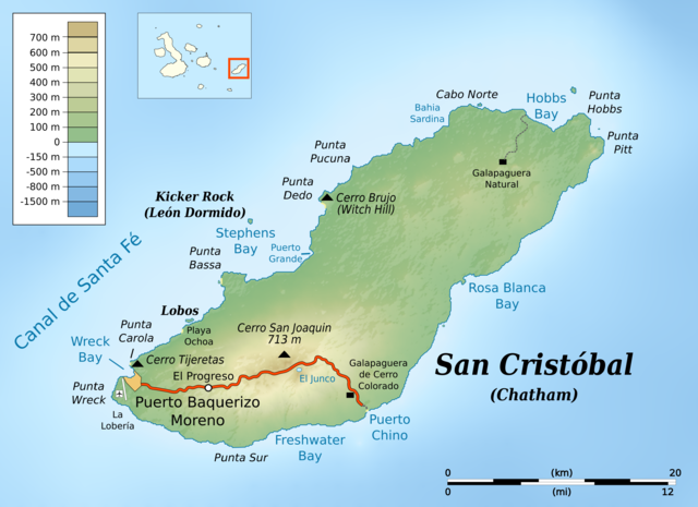
English: Topographic map of en:San Cristóbal Island
cylindrical equidistant projection, central meridian -89° 10', standard parallel 0° |
|||||||
| Date | ||||||||
| Source |
own work, using: |
|||||||
| Author | Bamse | |||||||
| Permission (Reusing this file) |
|
|||||||
| Other versions |
|


File history
Click on a date/time to view the file as it appeared at that time.
| Date/Time | Thumbnail | Dimensions | User | Comment | |
|---|---|---|---|---|---|
| current | 09:17, 10 June 2016 | | 3,189 × 2,319 (1.55 MB) | Bamse | {{Information |Description ={{en|1=Topographic map of en:San Cristóbal Island}} cylindrical equidistant projection, central meridian -89° 10', standard parallel 0° |Source =own work, using: * [[:File:Ecuador Galápagos Islands locati... |
File usage
The following pages on the English Wikipedia use this file (pages on other projects are not listed):
Global file usage
The following other wikis use this file:
- Usage on da.wikipedia.org
- Usage on fa.wikipedia.org
- Usage on ja.wikipedia.org
- Usage on mk.wikipedia.org
- Usage on uk.wikipedia.org